
Iowa County, Iowa facts for kids
Quick facts for kids
Iowa County
|
|
|---|---|

Iowa County Courthouse in Marengo
|
|

Location within the U.S. state of Iowa
|
|
 Iowa's location within the U.S. |
|
| Country | |
| State | |
| Founded | 1843 |
| Named for | Iowa River |
| Seat | Marengo |
| Largest city | Williamsburg |
| Area | |
| • Total | 587 sq mi (1,520 km2) |
| • Land | 586 sq mi (1,520 km2) |
| • Water | 1.0 sq mi (3 km2) 0.2% |
| Population
(2020)
|
|
| • Total | 16,662 |
| • Density | 28.385/sq mi (10.960/km2) |
| Time zone | UTC−6 (Central) |
| • Summer (DST) | UTC−5 (CDT) |
| Congressional district | 1st |
Iowa County is a place in the state of Iowa, USA. It's like a big neighborhood with its own local government. In 2020, about 16,662 people lived here. The main town, where the county government is located, is Marengo.
Did you know Iowa County is one of only seven counties in the United States that has the same name as its state? The others are Arkansas County, Hawaii County, Idaho County, New York County, Oklahoma County, and Utah County.
Contents
History of Iowa County
Iowa County was officially created on February 17, 1843. It got its name from the Iowa River, which flows right through it.
Early Courthouses
The very first building used as a courthouse was a simple log cabin. This was in 1847. The county rented it until 1850 when a new courthouse was finished.
Later, in 1861, work began on a third courthouse. The building used today was built in 1892. This happened because the county had grown too big for the older buildings.
The Amana Colonies
Iowa County is famous for the Amana Colonies. This is a group of seven villages. They were settled by German Pietists. Pietists were a religious group who wanted to live a very simple and devoted life.
They first settled in New York state. But they wanted more quiet and isolated surroundings. So, they moved to Iowa County in 1855. Here, they lived a communal life. This means they shared everything and worked together. They lived this way until the mid-1930s.
Today, Amana is a popular place for tourists. People visit for its restaurants and craft shops. The Amana Colonies have been a special National Historic Landmark since 1965.
Geography of Iowa County
Iowa County covers about 587 square miles. Most of this area, about 586 square miles, is land. Only a small part, about 1 square mile, is water.
The Iowa River flows through the county. The north fork of the English River also crosses through it.
Main Roads
Many important roads run through Iowa County. These roads help people travel and connect different towns.
 Interstate 80
 U.S. Highway 6
 U.S. Highway 151
 Iowa Highway 21
 Iowa Highway 149
 Iowa Highway 220
 Iowa Highway 212
Neighboring Counties
Iowa County shares its borders with several other counties:
- Benton County (to the north)
- Linn County (to the northeast)
- Johnson County (to the east)
- Washington County (to the southeast)
- Keokuk County (to the south)
- Poweshiek County (to the west)
- Tama County (to the northwest)
People of Iowa County

The number of people living in Iowa County has changed over the years. In 1850, there were 822 people. By 2020, the population had grown to 16,662.
2020 Census Information
In 2020, the county had 16,662 residents. This means there were about 28 people living in each square mile. Most people, about 90%, were non-Hispanic White.
There were 7,341 homes in the county. About 6,811 of these homes were lived in.
2010 Census Information
The 2010 census counted 16,355 people in Iowa County. The population density was similar to 2020. There were 7,258 homes, and 6,677 of them were occupied.
Communities in Iowa County
Iowa County has several towns and smaller communities.
Cities
Census-Designated Places (CDPs)
These are areas that are like towns but are not officially incorporated as cities.
Other Small Communities
These are even smaller places that are not officially part of a city or CDP.
- Genoa Bluff
- Koszta
Townships
Counties in Iowa are divided into smaller areas called townships.
- English
- Greene
- Hartford
- Hilton
- Iowa
- Lincoln
- Marengo
- Pilot
- Sumner
- Troy
- Washington
- York
- New Liberty
Community Sizes (2020 Census)
This table shows the population of the cities and CDPs in Iowa County, based on the 2020 census. † means it's the county seat.
| Rank | City/Town/etc. | Type | Population (2020 Census) |
|---|---|---|---|
| 1 | Williamsburg | City | 3,346 |
| 2 | † Marengo | City | 2,435 |
| 3 | North English (partially in Keokuk County) | City | 1,065 |
| 4 | Victor (partially in Poweshiek County) | City | 875 |
| 5 | Middle Amana | CDP | 543 |
| 6 | Amana | CDP | 388 |
| 7 | Conroy | CDP | 252 |
| 8 | Ladora | City | 229 |
| 9 | Parnell | City | 194 |
| 10 | South Amana | CDP | 165 |
| 11 | West Amana | CDP | 140 |
| t-12 | Millersburg | City | 135 |
| t-12 | Homestead | CDP | 135 |
| 13 | High Amana | CDP | 113 |
| 14 | East Amana | CDP | 64 |
Education in Iowa County
Several public school districts serve the students in Iowa County.
- Belle Plaine Community School District, Belle Plaine
- Benton Community School District, Van Horne
- Clear Creek–Amana Community School District, Oxford
- English Valleys Community School District, North English
- H-L-V Community School District, Victor
- Iowa Valley Community School District, Marengo
- Williamsburg Community School District, Williamsburg
Images for kids
-
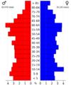
2022 Population Pyramid for Iowa County

See also
 In Spanish: Condado de Iowa (Iowa) para niños
