Dysart, Iowa facts for kids
Quick facts for kids
Dysart, Iowa
|
|
|---|---|

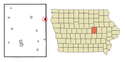
Location of Dysart, Iowa
|
|
| Country | |
| State | |
| County | Tama |
| Area | |
| • Total | 1.25 sq mi (3.24 km2) |
| • Land | 1.25 sq mi (3.24 km2) |
| • Water | 0.00 sq mi (0.00 km2) |
| Elevation | 971 ft (296 m) |
| Population
(2020)
|
|
| • Total | 1,281 |
| • Density | 1,023.98/sq mi (395.45/km2) |
| Time zone | UTC-6 (Central (CST)) |
| • Summer (DST) | UTC-5 (CDT) |
| ZIP code |
52224
|
| Area code(s) | 319 |
| FIPS code | 19-23160 |
| GNIS feature ID | 0456087 |
Dysart is a small city located in Tama County, Iowa, in the United States. In 2020, about 1,281 people lived there. The city is led by its Mayor, Tim Glenn.
Contents
Dysart's History
Dysart began in 1872. This was after the Burlington, Cedar Rapids and Northern Railway built a railroad through the area. The town was officially planned out in 1872. Dysart is named after Joseph Dysart, who was a farmer and helped start the town.
Where is Dysart?
Dysart is located in the state of Iowa. Its exact coordinates are 42 degrees, 10 minutes, 8 seconds North and 92 degrees, 18 minutes, 29 seconds West.
The United States Census Bureau says that Dysart covers about 1.25 square miles (3.24 square kilometers) of land. There is no water area within the city limits.
Population and People
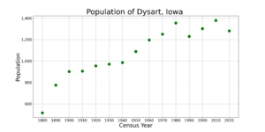
| Historical populations | ||
|---|---|---|
| Year | Pop. | ±% |
| 1880 | 516 | — |
| 1890 | 775 | +50.2% |
| 1900 | 902 | +16.4% |
| 1910 | 906 | +0.4% |
| 1920 | 955 | +5.4% |
| 1930 | 971 | +1.7% |
| 1940 | 986 | +1.5% |
| 1950 | 1,089 | +10.4% |
| 1960 | 1,197 | +9.9% |
| 1970 | 1,251 | +4.5% |
| 1980 | 1,355 | +8.3% |
| 1990 | 1,230 | −9.2% |
| 2000 | 1,303 | +5.9% |
| 2010 | 1,379 | +5.8% |
| 2020 | 1,281 | −7.1% |
| Source: and Iowa Data Center Source: |
||
Every ten years, the United States counts its population in a census. This helps us understand how many people live in different places.
Dysart's Population in 2020
In 2020, the census showed that 1,281 people lived in Dysart. There were 527 households, which are groups of people living together in one home. About 346 of these households were families.
The city had about 1,024 people per square mile. Most of the people living in Dysart (about 95.8%) were White. A small number of people were from other racial groups. About 1.2% of the population was Hispanic or Latino.
About 28.8% of the households had children under 18 living there. The average age of people in Dysart was 43.8 years old. About 26% of the residents were under 20 years old.
Dysart's Population in 2010
In 2010, the census counted 1,379 people in Dysart. There were 544 households. The population density was about 1,103 people per square mile.
Most people (97.6%) were White. About 1.5% of the population was Hispanic or Latino.
About 31.8% of households had children under 18. The average age in the city was 42 years. About 26% of residents were under 18 years old.
Education in Dysart
The Union Community School District serves the city of Dysart. This school district was created in 1993. It was formed when the Dysart-Geneseo Community School District and the La Porte City Community School District joined together.
Dysart has an elementary school called Dysart-Geneseo Elementary School. It teaches students from kindergarten through fifth grade. The high school for Dysart students is Union High School, located in La Porte City.
The Union Middle School and another elementary school are located in Dysart. The main office for the school district is in La Porte City.
See also
 In Spanish: Dysart (Iowa) para niños
 | Chris Smalls |
 | Fred Hampton |
 | Ralph Abernathy |


