
Coralville Lake facts for kids
Quick facts for kids Coralville Lake |
|
|---|---|

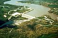
Coralville Dam on June 15, 2008, with the main control gates fully opened, and water flowing over the concrete emergency spillway (left) at about 5 ft (1.5 m) deep
|
|

Coralville Lake
Location in Iowa
|
|
| Location | Johnson County, Iowa, United States |
| Coordinates | 41°43′28″N 91°31′47″W / 41.72444°N 91.52972°W |
| Type | reservoir |
| Primary inflows | Iowa River |
| Primary outflows | Iowa River |
| Catchment area | Upper Mississippi River |
| Basin countries | United States |
| Water volume | 461,200 acre⋅ft (568,900,000 m3) |
Coralville Lake is a large, man-made lake in Johnson County, Iowa, in the United States. It was created by the Coralville Dam, which was built on the Iowa River. The dam and lake help control floods and offer many fun activities for people to enjoy.
Building Coralville Lake
| Coralville Dam | |
|---|---|
| Country | United States |
| Location | Johnson County, Iowa |
| Status | Operational |
| Construction began | 1949 |
| Opening date | 1958 |
| Construction cost | $15,744,000 |
| Owner(s) | U.S. Army Corps of Engineers |
| Dam and spillways | |
| Type of dam | Earth Filled Embankment |
| Impounds | Iowa River |
| Height | 100 ft (30 m) |
| Length | 1,400 ft (427 m) |
| Width (crest) | 22 ft (7 m) |
| Width (base) | 850 ft (259 m) |
| Reservoir | |
| Creates | Coralville Lake |
| Total capacity | 28,100 acre⋅ft (34,660,840 m3) (Normal pool); 421,000 acre⋅ft (519,295,854 m3) (Flood storage pool) |
| Catchment area | 3,084 sq mi (7,988 km2) |
| Surface area | 5,280 acres (2,140 ha) (Normal pool); 24,800 acres (10,000 ha) (Flood storage pool) |
| Maximum length | 23 mi (37 km) (Normal pool); 41.5 mi (67 km) (Flood storage pool) |
| Normal elevation | 679–717 ft (207–219 m) above msl |
| Website http://www.mvr.usace.army.mil/Missions/Recreation/Coralville-Lake/ |
|
After big floods happened in the United States in the 1930s, the U.S. Congress decided to take action. They passed a law called the Flood Control Act of 1938. This law helped create projects to prevent future flooding.
The United States Army Corps of Engineers built the Coralville Dam. It is an earthen dam, meaning it's made mostly of earth and rock. The dam is about 100 feet (30 meters) tall. Its main purpose was to control floods, especially for the Mississippi River.
Construction on the dam began in 1949. There was a delay because of the Korean War, but the dam was finally finished in 1958.
Coralville Lake can hold a huge amount of water. At its highest flood level, it can hold about 461,200 acre-feet of water. This is like 137.18 billion gallons!
Major Floods
The dam has been tested by large floods over the years. In 1993, during the Great Flood of 1993, water flowed over the emergency spillway for the first time. This spillway is a special channel designed to release water when the lake gets too full. This flood was so big that it uncovered an amazing area now called the Devonian Fossil Gorge. Here, you can see ancient fossils from millions of years ago!
The record for the highest water level was broken again in 2008 during the June 2008 Midwest floods. Water once more flowed over the emergency spillway. The lake reached its highest level ever on June 15, 2008.
During the 2008 flood, another lake nearby, Lake Macbride, also overflowed. It became connected to Coralville Lake for a while because of all the extra water.
Fun at Coralville Lake
Coralville Lake and the land around it are great places for outdoor activities. Many areas have been set up for public use.
You can enjoy:
- Hiking and biking on many trails
- Camping at one of the three campgrounds, which have 620 campsites
- Fishing and boating on the lake
- Swimming at four different beaches
- Visiting one of the 11 recreation areas
- Using one of the 18 boat ramps
- Having picnics at seven large picnic shelters
- Playing disc golf on two different courses
There are seven trails around the lake, totaling about 29 miles (47 kilometers) in length.
Images for kids
-
Coralville Dam and Reservoir near Coralville, Iowa.
-
A tackle shop near Coralville Dam.
-
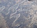
Coralville Lake as seen from the airplane during winter


