Audubon County, Iowa facts for kids
Quick facts for kids
Audubon County
|
|
|---|---|

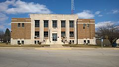
Audubon County Courthouse in Audubon
|
|

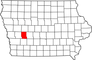
Location within the U.S. state of Iowa
|
|
 Iowa's location within the U.S. |
|
| Country | |
| State | |
| Founded | 1851 |
| Named for | John James Audubon |
| Seat | Audubon |
| Largest city | Audubon |
| Area | |
| • Total | 443 sq mi (1,150 km2) |
| • Land | 443 sq mi (1,150 km2) |
| • Water | 0.4 sq mi (1 km2) 0.1% |
| Population
(2020)
|
|
| • Total | 5,674 |
| • Density | 12.808/sq mi (4.945/km2) |
| Time zone | UTC−6 (Central) |
| • Summer (DST) | UTC−5 (CDT) |
| Congressional district | 4th |
Audubon County is a county located in the state of Iowa in the United States. In 2020, about 5,674 people lived there. This makes it one of the counties in Iowa with fewer people.
The main town, or county seat, is Audubon. The county was named after John James Audubon. He was a famous person who studied nature and was also an artist.
Contents
History of Audubon County
Audubon County was officially started on January 15, 1851. It was created from parts of another county called Pottawattamie County.
The county was named to honor John James Audubon. The main building for the county government, called the Audubon County Court House, first opened in 1940.
Geography of Audubon County
Audubon County covers an area of about 443 square miles. Most of this area is land. Only a very small part, about 0.4 square miles, is water.
Main Roads in Audubon County
These are some of the important highways that go through Audubon County:
Neighboring Counties
Audubon County shares its borders with these other counties:
- Carroll County to the north
- Guthrie County to the east
- Cass County to the south
- Shelby County to the west
People in Audubon County
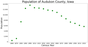
The number of people living in Audubon County has changed over the years. Here is a look at the population from different census counts.
| Historical population | |||
|---|---|---|---|
| Census | Pop. | %± | |
| 1860 | 454 | — | |
| 1870 | 1,212 | 167.0% | |
| 1880 | 7,448 | 514.5% | |
| 1890 | 12,412 | 66.6% | |
| 1900 | 13,626 | 9.8% | |
| 1910 | 12,671 | −7.0% | |
| 1920 | 12,520 | −1.2% | |
| 1930 | 12,264 | −2.0% | |
| 1940 | 11,790 | −3.9% | |
| 1950 | 11,579 | −1.8% | |
| 1960 | 10,919 | −5.7% | |
| 1970 | 9,595 | −12.1% | |
| 1980 | 8,559 | −10.8% | |
| 1990 | 7,334 | −14.3% | |
| 2000 | 6,830 | −6.9% | |
| 2010 | 6,119 | −10.4% | |
| 2020 | 5,674 | −7.3% | |
| 2023 (est.) | 5,534 | −9.6% | |
| U.S. Decennial Census 1790-1960 1900-1990 1990-2000 2010-2018 |
|||
2020 Census Information
The 2020 census counted 5,674 people living in Audubon County. This means there were about 12.8 people for every square mile.
Most people (97.41%) said they belonged to one race. About 94.87% were non-Hispanic White. There were 2,787 homes in the county, and 2,498 of them were lived in.
2010 Census Information
In the 2010 census, the population of Audubon County was 6,119 people. The population density was about 13.8 people per square mile.
There were 2,972 homes counted. Out of these, 2,617 were being lived in.
Towns and Communities
Audubon County has several towns and smaller communities.
Cities in Audubon County
Townships in Audubon County
Audubon County is divided into twelve smaller areas called townships:
City Population Ranking
This table shows the cities in Audubon County based on how many people lived there in the 2020 census. † This symbol means it is the county seat.
| Rank | City/Town/etc. | Municipal type | Population (2020 Census) |
|---|---|---|---|
| 1 | † Audubon | City | 2,053 |
| 2 | Exira | City | 787 |
| 3 | Kimballton | City | 291 |
| 4 | Brayton | City | 143 |
| 5 | Gray | City | 61 |
See also
 In Spanish: Condado de Audubon para niños
 | Misty Copeland |
 | Raven Wilkinson |
 | Debra Austin |
 | Aesha Ash |


