Gray, Iowa facts for kids
Quick facts for kids
Gray, Iowa
|
|
|---|---|
 |
|

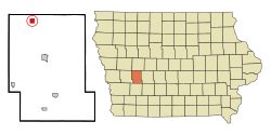
Location of Gray, Iowa
|
|
| Country | |
| State | |
| County | Audubon |
| Area | |
| • Total | 1.00 sq mi (2.58 km2) |
| • Land | 1.00 sq mi (2.58 km2) |
| • Water | 0.00 sq mi (0.00 km2) |
| Elevation | 1,365 ft (416 m) |
| Population
(2020)
|
|
| • Total | 61 |
| • Density | 61.24/sq mi (23.64/km2) |
| Time zone | UTC-6 (Central (CST)) |
| • Summer (DST) | UTC-5 (CDT) |
| ZIP code |
50110
|
| Area code(s) | 712 |
| FIPS code | 19-32565 |
| GNIS feature ID | 0457084 |
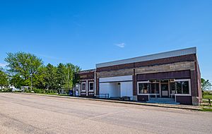
Gray is a small city located in Audubon County, Iowa, in the United States. It sits near the East Branch of the West Nishnabotna River. In 2020, about 61 people lived in Gray.
Contents
History of Gray
Gray was founded in 1881 by a person named George Gray. The city was named after him. In 1882, the Northwestern railroad line was built to reach the town.
Geography of Gray
Gray is located at coordinates 41°50′24″N 94°58′57″W / 41.84000°N 94.98250°W. This means it's in a specific spot on the map.
The United States Census Bureau says that Gray covers a total area of about 1.00 square mile (2.58 square kilometers). All of this area is land, with no water.
Population and People
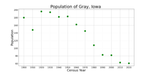
| Historical populations | ||
|---|---|---|
| Year | Pop. | ±% |
| 1900 | 180 | — |
| 1910 | 148 | −17.8% |
| 1920 | 196 | +32.4% |
| 1930 | 194 | −1.0% |
| 1940 | 182 | −6.2% |
| 1950 | 183 | +0.5% |
| 1960 | 162 | −11.5% |
| 1970 | 145 | −10.5% |
| 1980 | 108 | −25.5% |
| 1990 | 83 | −23.1% |
| 2000 | 82 | −1.2% |
| 2010 | 63 | −23.2% |
| 2020 | 61 | −3.2% |
| Source: and Iowa Data Center Source: |
||
Gray's Population in 2020
According to the census taken in 2020, there were 61 people living in Gray. These people lived in 18 different households, and 17 of these were families.
The city had about 61 people per square mile (23.6 per square kilometer). There were 36 housing units, meaning places where people could live.
Most of the people in Gray were White (88.5%). A small number were Black or African American (1.6%). About 1.6% were from other races, and 8.2% were from two or more races. About 3.3% of the population identified as Hispanic or Latino.
Out of the 18 households:
- 33.3% had children under 18 living there.
- 55.6% were married couples living together.
- 22.2% were couples living together but not married.
- 22.2% had a female head of household with no spouse or partner.
- Only 5.6% of all households were not families.
- 5.6% of households had someone living alone who was 65 or older.
The average age of people in Gray was 35.2 years old.
- 32.8% of residents were under 20.
- 6.6% were between 20 and 24.
- 19.7% were between 25 and 44.
- 21.3% were between 45 and 64.
- 19.7% were 65 years or older.
The population was almost evenly split between males (50.8%) and females (49.2%).
Gray's Population in 2010
In the census of 2010, Gray had 63 people. There were 28 households and 15 families. The population density was about 63 people per square mile.
There were 36 housing units. Most of the people (98.4%) were White. About 1.6% were from two or more races.
Out of the 28 households:
- 21.4% had children under 18.
- 42.9% were married couples.
- 3.6% had a female head of household with no husband.
- 7.1% had a male head of household with no wife.
- 46.4% were not families.
- 39.3% of households were made up of individuals.
- 14.3% had someone living alone who was 65 or older.
The average household had 2.25 people, and the average family had 2.87 people.
The average age in 2010 was 41.3 years.
- 20.6% of residents were under 18.
- 17.4% were between 18 and 24.
- 17.5% were between 25 and 44.
- 22.2% were between 45 and 64.
- 22.2% were 65 or older.
The population was 46.0% male and 54.0% female.
See also
 In Spanish: Gray (Iowa) para niños
 | John T. Biggers |
 | Thomas Blackshear |
 | Mark Bradford |
 | Beverly Buchanan |


