Rhineland, Missouri facts for kids
Quick facts for kids
Rhineland, Missouri
|
|
|---|---|

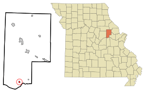
Location in Montgomery County and the state of Missouri
|
|
| Country | United States |
| State | Missouri |
| County | Montgomery |
| Area | |
| • Total | 0.34 sq mi (0.87 km2) |
| • Land | 0.34 sq mi (0.87 km2) |
| • Water | 0.00 sq mi (0.00 km2) |
| Elevation | 558 ft (170 m) |
| Population
(2020)
|
|
| • Total | 139 |
| • Density | 412.46/sq mi (159.37/km2) |
| Time zone | UTC-6 (Central (CST)) |
| • Summer (DST) | UTC-5 (CDT) |
| ZIP code |
65069
|
| Area code(s) | 573 |
| FIPS code | 29-61328 |
| GNIS feature ID | 2396876 |
Rhineland is a small village in Montgomery County, Missouri, United States. In 2020, about 139 people lived there. The village got its name from German immigrants. They came from the Rhine River area in Germany.
Rhineland is located near the Missouri River. In 1993, a very big flood, called the Great Flood of 1993, caused a lot of damage to the village. Rhineland was one of the first towns to get money from the government to move its buildings. All the houses were moved about 1.5 miles uphill to a safer spot.
Contents
History of Rhineland
Rhineland was first settled mostly by German people. They chose the name "Rhineland" because it reminded them of the Rhine River in their home country. A post office opened in Rhineland in 1853. The town's layout was officially planned in the same year.
The Heinrich Gloe House is a special old building in Rhineland. It was added to the National Register of Historic Places in 2007. This means it is an important historical site.
Where is Rhineland Located?
Rhineland is in the southern part of Montgomery County. It is about 1.5 miles north of the Missouri River. Missouri Route 94 used to pass through the old location of the village. Now, the village sits on a hill above that road. The city of Hermann is about 5 miles southeast. You can reach Hermann by crossing the Missouri River on State Highway 19.
According to the U.S. Census Bureau, Rhineland covers a total area of 0.34 square miles (0.87 square kilometers). All of this area is land.
How Many People Live in Rhineland?
The number of people living in Rhineland has changed over the years. Here is a quick look at the population from different census reports:
| Historical population | |||
|---|---|---|---|
| Census | Pop. | %± | |
| 1900 | 153 | — | |
| 1910 | 190 | 24.2% | |
| 1920 | 172 | −9.5% | |
| 1930 | 194 | 12.8% | |
| 1940 | 204 | 5.2% | |
| 1950 | 198 | −2.9% | |
| 1960 | 190 | −4.0% | |
| 1970 | 190 | 0.0% | |
| 1980 | 172 | −9.5% | |
| 1990 | 157 | −8.7% | |
| 2000 | 176 | 12.1% | |
| 2010 | 142 | −19.3% | |
| 2020 | 139 | −2.1% | |
| U.S. Decennial Census | |||
Rhineland's Population in 2010
In 2010, the census showed that 142 people lived in Rhineland. There were 60 households and 41 families. Most of the people (95.8%) were White. A small number were Asian (0.7%) or from two or more races (3.5%). About 0.7% of the population was Hispanic or Latino.
About 28.3% of households had children under 18 living with them. More than half (56.7%) were married couples. The average household had 2.37 people, and the average family had 2.93 people.
The average age of people in the village was 41.3 years. About 21.8% of residents were under 18. About 15.5% were 65 years old or older. The village had slightly more females (50.7%) than males (49.3%).
See also
 In Spanish: Rhineland (Misuri) para niños
 | Toni Morrison |
 | Barack Obama |
 | Martin Luther King Jr. |
 | Ralph Bunche |

