Clarksville, Missouri facts for kids
Quick facts for kids
Clarksville, Missouri
|
|
|---|---|

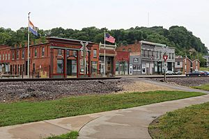
Clarksville, Missouri in June 2018
|
|

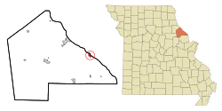
Location of Clarksville, Missouri
|
|
| Country | United States |
| State | Missouri |
| County | Pike |
| Area | |
| • Total | 0.94 sq mi (2.44 km2) |
| • Land | 0.58 sq mi (1.51 km2) |
| • Water | 0.36 sq mi (0.93 km2) |
| Elevation | 466 ft (142 m) |
| Population
(2020)
|
|
| • Total | 372 |
| • Density | 640.28/sq mi (247.12/km2) |
| Time zone | UTC-6 (Central (CST)) |
| • Summer (DST) | UTC-5 (CDT) |
| ZIP code |
63336
|
| Area code(s) | 573 |
| FIPS code | 29-14194 |
| GNIS feature ID | 2393545 |
| Website | http://www.clarksvillemo.us/ |
Clarksville is a small city in Pike County, Missouri, United States. It is located in Calumet Township. In 2020, the city had a population of 372 people. Clarksville is known for its history and its location near the Mississippi River.
Exploring Clarksville: A Missouri City
A Look Back: Clarksville's History
Clarksville was first planned out in 1819. The city was named after William Clark. He was a famous explorer and the governor of the territory at that time.
Several important places in Clarksville are listed on the National Register of Historic Places. These include the Clarksville Historic District, the Clifford-Wyrick House, and the Lock and Dam No. 24 Historic District. Also listed are the Northern Methodist Episcopal Church of Clarksville and the Turner-Pharr House. These places help preserve the city's past.
Clarksville celebrated its 200th birthday in 2017. This was a big event for the community.
Exploring Clarksville's Geography
Clarksville is right next to the mighty Mississippi River. It is also located on State Route 79. The city is about nine miles southeast of Louisiana, Missouri. There is an area called Clarksville Island in the Mississippi River. It is located east of the Missouri-Illinois state line.
The United States Census Bureau reports on the city's size. Clarksville covers a total area of about 0.82 square miles (2.12 square kilometers). Of this, about 0.46 square miles (1.19 square kilometers) is land. The remaining 0.36 square miles (0.93 square kilometers) is water.
Clarksville's Climate and Weather
Clarksville experiences a range of weather throughout the year. Here is a summary of the climate data:
| Climate data for Clarksville, Missouri (Lock and Dam No. 24) (1991–2020 normals, extremes 1992–present) | |||||||||||||
|---|---|---|---|---|---|---|---|---|---|---|---|---|---|
| Month | Jan | Feb | Mar | Apr | May | Jun | Jul | Aug | Sep | Oct | Nov | Dec | Year |
| Record high °F (°C) | 73 (23) |
78 (26) |
83 (28) |
91 (33) |
99 (37) |
105 (41) |
112 (44) |
104 (40) |
102 (39) |
93 (34) |
84 (29) |
74 (23) |
112 (44) |
| Mean daily maximum °F (°C) | 36.5 (2.5) |
41.4 (5.2) |
52.3 (11.3) |
65.0 (18.3) |
74.4 (23.6) |
83.5 (28.6) |
87.3 (30.7) |
85.8 (29.9) |
79.3 (26.3) |
67.1 (19.5) |
53.0 (11.7) |
41.1 (5.1) |
63.9 (17.7) |
| Daily mean °F (°C) | 28.1 (−2.2) |
32.4 (0.2) |
42.7 (5.9) |
54.4 (12.4) |
64.4 (18.0) |
73.9 (23.3) |
77.9 (25.5) |
76.2 (24.6) |
68.8 (20.4) |
56.7 (13.7) |
43.8 (6.6) |
33.1 (0.6) |
54.4 (12.4) |
| Mean daily minimum °F (°C) | 19.7 (−6.8) |
23.5 (−4.7) |
33.0 (0.6) |
43.8 (6.6) |
54.4 (12.4) |
64.2 (17.9) |
68.4 (20.2) |
66.7 (19.3) |
58.2 (14.6) |
46.3 (7.9) |
34.6 (1.4) |
25.1 (−3.8) |
44.8 (7.1) |
| Record low °F (°C) | −20 (−29) |
−15 (−26) |
−3 (−19) |
22 (−6) |
29 (−2) |
42 (6) |
43 (6) |
44 (7) |
34 (1) |
25 (−4) |
6 (−14) |
−3 (−19) |
−20 (−29) |
| Average precipitation inches (mm) | 2.05 (52) |
1.73 (44) |
3.01 (76) |
4.02 (102) |
4.60 (117) |
4.44 (113) |
3.91 (99) |
3.53 (90) |
3.21 (82) |
2.91 (74) |
3.00 (76) |
2.06 (52) |
38.47 (977) |
| Average snowfall inches (cm) | 4.5 (11) |
3.2 (8.1) |
1.4 (3.6) |
0.1 (0.25) |
0.0 (0.0) |
0.0 (0.0) |
0.0 (0.0) |
0.0 (0.0) |
0.0 (0.0) |
0.0 (0.0) |
0.1 (0.25) |
2.3 (5.8) |
11.6 (29) |
| Average precipitation days (≥ 0.01 in) | 8.0 | 7.8 | 10.4 | 11.2 | 12.4 | 10.7 | 8.6 | 7.7 | 7.2 | 9.1 | 8.6 | 8.9 | 110.6 |
| Average snowy days (≥ 0.1 in) | 3.1 | 1.7 | 0.6 | 0.1 | 0.0 | 0.0 | 0.0 | 0.0 | 0.0 | 0.0 | 0.3 | 1.7 | 7.5 |
| Source: NOAA | |||||||||||||
Who Lives Here: Clarksville's Population
The population of Clarksville has changed over many years. Here is a look at how the number of people living in the city has grown and shrunk:
| Historical population | |||
|---|---|---|---|
| Census | Pop. | %± | |
| 1850 | 300 | — | |
| 1860 | 573 | 91.0% | |
| 1870 | 1,152 | 101.0% | |
| 1880 | 1,493 | 29.6% | |
| 1890 | 1,186 | −20.6% | |
| 1900 | 843 | −28.9% | |
| 1910 | 918 | 8.9% | |
| 1920 | 729 | −20.6% | |
| 1930 | 739 | 1.4% | |
| 1940 | 879 | 18.9% | |
| 1950 | 702 | −20.1% | |
| 1960 | 638 | −9.1% | |
| 1970 | 668 | 4.7% | |
| 1980 | 585 | −12.4% | |
| 1990 | 480 | −17.9% | |
| 2000 | 490 | 2.1% | |
| 2010 | 442 | −9.8% | |
| 2020 | 372 | −15.8% | |
| U.S. Decennial Census | |||

Clarksville's 2010 Census Snapshot
In 2010, the census counted 442 people living in Clarksville. There were 210 households and 109 families. The city had about 961 people per square mile.
Most people in Clarksville were White (89.4%). About 7.2% were African American. A small number were from other races or mixed races. About 2.9% of the population was Hispanic or Latino.
About 23.8% of households had children under 18. Many households (36.7%) were married couples. Some households had a single parent. About 48.1% of households were not families. Also, 40% of all households had only one person living there. About 18.5% of these single-person households were people aged 65 or older.
The average age in Clarksville was 45.8 years. About 21.5% of residents were under 18. About 30% were between 45 and 64 years old. And 21% were 65 years or older. The city had slightly more males (51.8%) than females (48.2%).
Learning in Clarksville: Schools and Library
The Pike County R-III School District serves Clarksville. It operates two schools in the city. These are Clopton Elementary School and Clopton High School.
The town also has a place for reading and learning. It is called the Clarksville Public Library.
Fun Things to Do: Tourism in Clarksville
Clarksville is a great place for visitors. One popular event is the Eagle Days weekend. During this time, people can watch eagles and learn about birds. The Missouri Department of Conservation, the city, and the U.S. Army Corps of Engineers help put on this event.
A special attraction used to be a skylift. It was popular from the early 1960s to the early 1990s. This skylift offered amazing views of 800 square miles. This lookout point is the highest on the Mississippi River. There were plans to reopen it. However, the project has faced challenges. The skylift is located on an ancient Native American burial mound. The Sac and Fox Nation of Oklahoma has raised concerns about this.
See also
 In Spanish: Clarksville (Misuri) para niños
 | William Lucy |
 | Charles Hayes |
 | Cleveland Robinson |


