Warren County, Missouri facts for kids
Quick facts for kids
Warren County
|
|
|---|---|

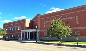
The Warren County Courthouse in Warrenton
|
|

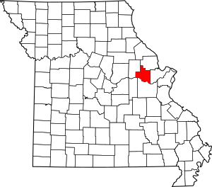
Location within the U.S. state of Missouri
|
|
 Missouri's location within the U.S. |
|
| Country | |
| State | |
| Founded | January 5, 1833 |
| Named for | General Joseph Warren |
| Seat | Warrenton |
| Largest city | Warrenton |
| Area | |
| • Total | 438 sq mi (1,130 km2) |
| • Land | 429 sq mi (1,110 km2) |
| • Water | 9.2 sq mi (24 km2) 2.1% |
| Population
(2020)
|
|
| • Total | 35,532 |
| • Density | 81.12/sq mi (31.32/km2) |
| Time zone | UTC−6 (Central) |
| • Summer (DST) | UTC−5 (CDT) |
| Congressional district | 3rd |
Warren County is a special area in the eastern part of Missouri, a state in the United States. In 2020, about 35,532 people lived there. It's found on the north side of the Missouri River. The main town, called the county seat, is Warrenton.
Warren County started on January 5, 1833. It was named after General Joseph Warren. He was a hero who died in the Battle of Bunker Hill during the American Revolutionary War.
Warren County is also part of the larger St. Louis area. A road called Route 94 goes through the county. It's known as the "Missouri Weinstrasse" (which means "Wine Road"). This is because there are many vineyards, or places where grapes for wine are grown, from Marthasville east into St. Charles County. Warren County is also part of the Missouri Rhineland, an area famous for its award-winning wineries.
Contents
About the Land
The U.S. Census Bureau says that Warren County covers a total area of 438 square miles. Most of this, 429 square miles, is land. The rest, about 9.2 square miles (or 2.1%), is water.
Neighboring Counties
Warren County shares borders with these other counties:
- Lincoln County (to the north)
- St. Charles County (to the east)
- Franklin County (to the south)
- Gasconade County (to the southwest)
- Montgomery County (to the west)
Main Roads
Several important roads pass through Warren County:
 Interstate 70
 U.S. Route 40
 Route 47
 Route 94
People of Warren County
| Historical population | |||
|---|---|---|---|
| Census | Pop. | %± | |
| 1840 | 4,253 | — | |
| 1850 | 5,860 | 37.8% | |
| 1860 | 8,839 | 50.8% | |
| 1870 | 9,673 | 9.4% | |
| 1880 | 10,806 | 11.7% | |
| 1890 | 9,913 | −8.3% | |
| 1900 | 9,919 | 0.1% | |
| 1910 | 9,123 | −8.0% | |
| 1920 | 8,490 | −6.9% | |
| 1930 | 8,082 | −4.8% | |
| 1940 | 7,734 | −4.3% | |
| 1950 | 7,666 | −0.9% | |
| 1960 | 8,750 | 14.1% | |
| 1970 | 9,699 | 10.8% | |
| 1980 | 14,900 | 53.6% | |
| 1990 | 19,534 | 31.1% | |
| 2000 | 24,525 | 25.6% | |
| 2010 | 32,513 | 32.6% | |
| 2020 | 35,532 | 9.3% | |
| U.S. Decennial Census 1790-1960 1900-1990 1990-2000 2010 |
|||
In 2000, there were 24,525 people living in Warren County. About 57 people lived in each square mile. Most people (about 95.89%) were White. About 1.94% were Black or African American.
Many families lived in the county. About 34.70% of households had children under 18. Most households (62.20%) were married couples. The average household had 2.64 people.
The population was spread out by age. About 26.90% were under 18 years old. About 13.00% were 65 years or older. The average age was 37 years.
2020 Census Update
| Race | Num. | Perc. |
|---|---|---|
| White (NH) | 31,103 | 87.53% |
| Black or African American (NH) | 718 | 2% |
| Native American (NH) | 116 | 0.33% |
| Asian (NH) | 143 | 0.4% |
| Pacific Islander (NH) | 0 | 0% |
| Other/Mixed (NH) | 2,052 | 5.8% |
| Hispanic or Latino | 1,400 | 4% |
Schools and Learning
Warren County has several schools for students.
Public Schools
- Warren County R-III School District in Warrenton
- Daniel Boone Elementary School (Grades PK-5)
- Warrior Ridge Elementary School (Grades K-5)
- Rebecca Boone Elementary School (Grades K-5)
- Black Hawk Middle School (Grades 6-8)
- Warrenton High School (Grades 9-12)
- Wright City R-II School District in Wright City
- Wright City East Elementary School (Grades K-1) in Foristell
- Wright City Elementary School (Grades 2-5)
- Wright City Middle School (Grades 6-8)
- Wright City High School (Grades 9-12)
Private Schools
- Holy Rosary School in Warrenton (Grades K-8) – A Roman Catholic school.
- St. Vincent De Paul School in Marthasville (Grades K-8) – A Roman Catholic school.
- St. Ignatius Loyola School in Marthasville (Grades PK-8) – A Roman Catholic school.
Public Libraries
- Warrenton Branch Library
Towns and Villages
Warren County has several communities, including cities, villages, and smaller unincorporated areas.
Cities
- Foristell (partly in St. Charles County)
- Marthasville
- Truesdale
- Warrenton (the county seat)
- Wright City
Villages
Unincorporated Communities
These are smaller places that are not officially cities or villages.
Media Outlets
Warren County has local radio stations:
- KFAV, 99.9 FM – Plays country music. It's a sister station to KWRE.
- KWRE, 730 AM – Also plays country music. It's a sister station to KFAV.
See also
 In Spanish: Condado de Warren (Misuri) para niños
 | William M. Jackson |
 | Juan E. Gilbert |
 | Neil deGrasse Tyson |

