Middletown, Missouri facts for kids
Quick facts for kids
Middletown, Missouri
|
|
|---|---|

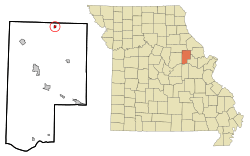
Location in Montgomery County and the state of Missouri
|
|
| Country | United States |
| State | Missouri |
| County | Montgomery |
| Area | |
| • Total | 0.32 sq mi (0.83 km2) |
| • Land | 0.32 sq mi (0.83 km2) |
| • Water | 0.00 sq mi (0.00 km2) |
| Elevation | 702 ft (214 m) |
| Population
(2020)
|
|
| • Total | 171 |
| • Density | 532.71/sq mi (205.36/km2) |
| Time zone | UTC-6 (Central (CST)) |
| • Summer (DST) | UTC-5 (CDT) |
| ZIP code |
63359
|
| Area code(s) | 573 |
| FIPS code | 29-47900 |
| GNIS feature ID | 2396760 |
Middletown is a small city located in Montgomery County, Missouri, in the United States. In 2020, about 171 people lived there. It's a quiet place in the heart of Missouri.
Contents
History of Middletown
Middletown was first planned and settled in 1834. It got its name because it was located in the middle of an important farming area. People thought it was a good central spot for the community.
Geography of Middletown
Middletown is found in the northern part of Montgomery County. You can find its exact spot using these coordinates: 39°7′39″N 91°24′53″W / 39.12750°N 91.41472°W.
A main road, Missouri Route 161, goes through the southern part of the city. This road is also known as Johnson Street. If you go southwest on Route 161 for about 14 miles (23 km), you'll reach Montgomery City, which is the main town for the county. If you head northeast for about 21 miles (34 km), you'll get to Bowling Green.
The city covers a total area of about 0.32 square miles (0.83 square kilometers), and all of it is land. A small stream called Coon Creek flows through the southwest part of Middletown. Coon Creek eventually joins the West Fork of the Cuivre River, which then flows into the mighty Mississippi River.
Population and People
| Historical population | |||
|---|---|---|---|
| Census | Pop. | %± | |
| 1880 | 391 | — | |
| 1890 | 389 | −0.5% | |
| 1900 | 375 | −3.6% | |
| 1910 | 323 | −13.9% | |
| 1920 | 279 | −13.6% | |
| 1930 | 235 | −15.8% | |
| 1940 | 243 | 3.4% | |
| 1950 | 240 | −1.2% | |
| 1960 | 199 | −17.1% | |
| 1970 | 235 | 18.1% | |
| 1980 | 268 | 14.0% | |
| 1990 | 217 | −19.0% | |
| 2000 | 199 | −8.3% | |
| 2010 | 167 | −16.1% | |
| 2020 | 171 | 2.4% | |
| U.S. Decennial Census | |||
The population of Middletown has changed over the years. You can see how the number of people living there has gone up and down in the table above, which shows data from the U.S. Census.
Middletown's Population in 2010
In 2010, the city had 167 people living in 79 different homes. The city was home to about 522 people per square mile (202 people per square kilometer). There were also 104 housing units, which are places where people can live.
About 24% of the homes had children under 18 living there. Many homes were families, including married couples. Other homes included single parents or individuals living alone. About 19% of the homes had someone 65 years old or older living by themselves.
The average age of people in Middletown in 2010 was about 46 years old. About 20% of the residents were under 18, and about 25% were 65 or older. The population was made up of slightly more males (56.3%) than females (43.7%).
See also
 In Spanish: Middletown (Misuri) para niños
 | Georgia Louise Harris Brown |
 | Julian Abele |
 | Norma Merrick Sklarek |
 | William Sidney Pittman |

