Jonesburg, Missouri facts for kids
Quick facts for kids
Jonesburg, Missouri
|
|
|---|---|

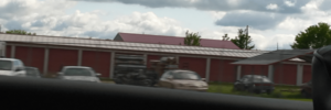
Jonesburg in May 2024
|
|

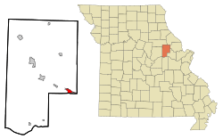
Location in Montgomery County and the state of Missouri
|
|
| Country | United States |
| State | Missouri |
| County | Montgomery |
| Area | |
| • Total | 1.72 sq mi (3.98 km2) |
| • Land | 1.72 sq mi (3.98 km2) |
| • Water | 0.00 sq mi (0.00 km2) |
| Elevation | 889 ft (271 m) |
| Population
(2020)
|
|
| • Total | 726 |
| • Density | 472.96/sq mi (182.59/km2) |
| Time zone | UTC-6 (Central (CST)) |
| • Summer (DST) | UTC-5 (CDT) |
| ZIP code |
63351
|
| Area code(s) | 636 |
| FIPS code | 29-37574 |
| GNIS feature ID | 2395481 |
Jonesburg is a small city in Montgomery County, Missouri, in the United States. In 2020, about 726 people lived there. It's a quiet place with a rich history in the state of Missouri.
Jonesburg's History
Jonesburg was officially planned and laid out in 1858. It was named after James Jones, who was an important person in the area long ago. A post office first opened here in 1868, and it was called "Jonesburgh." Later, in 1893, the name was changed to "Jonesburg," which is what it's called today.
Where is Jonesburg?
Jonesburg is located in the eastern part of Montgomery County, Missouri. Part of its southern edge touches the border of Warren County. A major highway, Interstate 70 (also known as U.S. Route 40), runs through the northern side of the city. You can get to Jonesburg from Exit 183.
If you travel east on I-70, you'll reach St. Louis in about 66 miles (106 km). If you go west, you'll get to Columbia in about 58 miles (93 km).
The city covers an area of about 1.72 square miles (4.45 km2), and all of it is land. Jonesburg sits on a wide, raised area of land. Water from the north side of this ridge flows into Little Bear Creek, which eventually reaches the Mississippi River. Water from the south side flows into Bear Creek, which leads to the Missouri River.
People of Jonesburg
| Historical population | |||
|---|---|---|---|
| Census | Pop. | %± | |
| 1880 | 445 | — | |
| 1890 | 437 | −1.8% | |
| 1900 | 407 | −6.9% | |
| 1910 | 456 | 12.0% | |
| 1920 | 473 | 3.7% | |
| 1930 | 432 | −8.7% | |
| 1940 | 422 | −2.3% | |
| 1950 | 433 | 2.6% | |
| 1960 | 415 | −4.2% | |
| 1970 | 479 | 15.4% | |
| 1980 | 614 | 28.2% | |
| 1990 | 630 | 2.6% | |
| 2000 | 695 | 10.3% | |
| 2010 | 768 | 10.5% | |
| 2020 | 726 | −5.5% | |
| U.S. Decennial Census | |||
The population of Jonesburg has changed over the years. In 1880, there were 445 people. The population grew to 768 people by 2010, but then slightly decreased to 726 people in 2020.
Population in 2010
According to the census from 2010, 768 people lived in Jonesburg. There were 281 households, which are groups of people living together in one home.
About 24.1% of the people living in Jonesburg were under 18 years old. About 25.3% were 65 years old or older. The average age in the city was 41.3 years.
See also
- Jonesburg (Misuri) for kids (in Spanish)
 | Toni Morrison |
 | Barack Obama |
 | Martin Luther King Jr. |
 | Ralph Bunche |

