Vandalia, Missouri facts for kids
Quick facts for kids
Vandalia, Missouri
|
|
|---|---|
| City of Vandalia | |

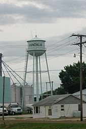
Water tower in Vandalia
|
|

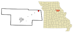
Location of Vandalia, Missouri
|
|
| Country | United States |
| State | Missouri |
| Counties | Audrain, Ralls |
| Area | |
| • Total | 2.25 sq mi (5.82 km2) |
| • Land | 2.24 sq mi (5.81 km2) |
| • Water | 0.01 sq mi (0.01 km2) |
| Elevation | 764 ft (233 m) |
| Population
(2020)
|
|
| • Total | 3,553 |
| • Estimate
(2023)
|
3,464 |
| • Density | 1,583.33/sq mi (611.44/km2) |
| Time zone | UTC-6 (Central (CST)) |
| • Summer (DST) | UTC-5 (CDT) |
| ZIP code |
63382
|
| Area code(s) | 573 |
| FIPS code | 29-75688 |
| GNIS feature ID = | 2397120 |
Vandalia is a city in the state of Missouri, USA. It is located in both Audrain and Ralls Counties. In 2020, about 3,553 people lived there. This number includes people living in a large state facility within the city.
The part of Vandalia in Audrain County is near Mexico. The part in Ralls County is near Hannibal.
Contents
History of Vandalia
How Vandalia Started
Vandalia was first planned in 1870 by Aaron McPike and Judge Harmen Caldwell. The city was officially mapped out in 1871. It was named after another city called Vandalia, Illinois.
The first homes in Vandalia were built with lumber brought from Louisiana, Missouri. A post office has been open in Vandalia since 1871.
Historic Buildings in Vandalia
The Lincoln School is a special building in Vandalia. It was added to the National Register of Historic Places in 1996. This means it is an important historical site.
Geography and Location
Where is Vandalia?
Vandalia is located on US Route 54. This is in the northeastern part of Audrain County. It is about 15 miles west of Bowling Green.
The city is about 27 miles from the Mississippi River. It is also about 30 miles southwest of Hannibal. St. Louis is about 100 miles northwest of Vandalia.
Transportation in Vandalia
A train line called the Gateway Western Railroad runs through Vandalia. US Route 54 connects Vandalia to Illinois in the east. It also connects to Jefferson City and the Lake of the Ozarks to the south and west.
Land and Water Area
Vandalia covers a total area of about 2.25 square miles (5.82 square kilometers). Most of this area is land, about 2.24 square miles (5.81 square kilometers). Only a very small part, about 0.01 square miles (0.01 square kilometers), is water.
Vandalia's Climate
Vandalia has a climate with warm summers and cold winters. The hottest month is usually July, and the coldest is January. The city gets a good amount of rain throughout the year.
| Climate data for Vandalia, Missouri (1991–2020 normals, extremes 1911–present) | |||||||||||||
|---|---|---|---|---|---|---|---|---|---|---|---|---|---|
| Month | Jan | Feb | Mar | Apr | May | Jun | Jul | Aug | Sep | Oct | Nov | Dec | Year |
| Record high °F (°C) | 77 (25) |
81 (27) |
88 (31) |
92 (33) |
96 (36) |
105 (41) |
108 (42) |
106 (41) |
108 (42) |
93 (34) |
88 (31) |
74 (23) |
108 (42) |
| Mean maximum °F (°C) | 60.0 (15.6) |
65.0 (18.3) |
75.3 (24.1) |
83.0 (28.3) |
87.0 (30.6) |
92.4 (33.6) |
95.2 (35.1) |
95.6 (35.3) |
90.9 (32.7) |
84.3 (29.1) |
72.6 (22.6) |
63.7 (17.6) |
97.4 (36.3) |
| Mean daily maximum °F (°C) | 35.7 (2.1) |
40.8 (4.9) |
52.2 (11.2) |
64.2 (17.9) |
73.6 (23.1) |
82.5 (28.1) |
86.4 (30.2) |
85.1 (29.5) |
78.6 (25.9) |
66.6 (19.2) |
52.5 (11.4) |
40.5 (4.7) |
63.2 (17.3) |
| Daily mean °F (°C) | 27.1 (−2.7) |
31.5 (−0.3) |
41.8 (5.4) |
53.1 (11.7) |
63.4 (17.4) |
72.5 (22.5) |
76.4 (24.7) |
74.7 (23.7) |
67.2 (19.6) |
55.2 (12.9) |
42.6 (5.9) |
32.1 (0.1) |
53.1 (11.7) |
| Mean daily minimum °F (°C) | 18.5 (−7.5) |
22.1 (−5.5) |
31.4 (−0.3) |
42.0 (5.6) |
53.2 (11.8) |
62.6 (17.0) |
66.4 (19.1) |
64.3 (17.9) |
55.8 (13.2) |
43.9 (6.6) |
32.6 (0.3) |
23.7 (−4.6) |
43.0 (6.1) |
| Mean minimum °F (°C) | −1.2 (−18.4) |
3.7 (−15.7) |
13.8 (−10.1) |
28.1 (−2.2) |
39.5 (4.2) |
51.5 (10.8) |
56.9 (13.8) |
55.4 (13.0) |
41.8 (5.4) |
29.4 (−1.4) |
17.3 (−8.2) |
5.7 (−14.6) |
−4.8 (−20.4) |
| Record low °F (°C) | −24 (−31) |
−16 (−27) |
−12 (−24) |
18 (−8) |
29 (−2) |
35 (2) |
45 (7) |
40 (4) |
32 (0) |
20 (−7) |
−5 (−21) |
−24 (−31) |
−24 (−31) |
| Average precipitation inches (mm) | 2.20 (56) |
2.27 (58) |
3.35 (85) |
4.23 (107) |
4.97 (126) |
5.07 (129) |
4.59 (117) |
3.37 (86) |
3.69 (94) |
2.76 (70) |
2.73 (69) |
2.04 (52) |
41.27 (1,048) |
| Average precipitation days (≥ 0.01 in) | 6.4 | 6.5 | 9.2 | 10.2 | 11.6 | 9.8 | 8.1 | 7.2 | 7.5 | 8.7 | 6.7 | 7.2 | 99.1 |
| Source: NOAA | |||||||||||||
Population and People
How Many People Live Here?
| Historical population | |||
|---|---|---|---|
| Census | Pop. | %± | |
| 1880 | 501 | — | |
| 1890 | 979 | 95.4% | |
| 1900 | 1,168 | 19.3% | |
| 1910 | 1,595 | 36.6% | |
| 1920 | 2,158 | 35.3% | |
| 1930 | 2,450 | 13.5% | |
| 1940 | 2,672 | 9.1% | |
| 1950 | 2,624 | −1.8% | |
| 1960 | 3,055 | 16.4% | |
| 1970 | 3,160 | 3.4% | |
| 1980 | 3,170 | 0.3% | |
| 1990 | 2,683 | −15.4% | |
| 2000 | 2,529 | −5.7% | |
| 2010 | 3,899 | 54.2% | |
| 2020 | 3,553 | −8.9% | |
| U.S. Decennial Census | |||
In 2010, Vandalia had 3,899 people living in 1,105 households. About 671 of these were families. The city had about 1,740 people per square mile.
Who Lives in Vandalia?
The average age of people in Vandalia in 2010 was 37 years old. About 15% of the residents were under 18 years old. Most of the population, about 70.5%, was female.
Education in Vandalia
Schools in the Area
The Van-Far R-I School District serves Vandalia. It has an elementary school and a middle school. There is also the Van-Far Jr./Sr. High School for older students.
Local Library
Vandalia also has a public library. It is a branch of the Mexico-Audrain Library District. This library offers books and resources for everyone in the community.
See also
 In Spanish: Vandalia (Misuri) para niños
 | Lonnie Johnson |
 | Granville Woods |
 | Lewis Howard Latimer |
 | James West |

