
Carter County, Missouri facts for kids
Quick facts for kids
Carter County
|
|
|---|---|

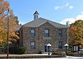
Carter County Courthouse in Van Buren
|
|

Location within the U.S. state of Missouri
|
|
 Missouri's location within the U.S. |
|
| Country | |
| State | |
| Founded | March 10, 1859 |
| Named for | Zimri A. Carter, a pioneer settler who came to Missouri from South Carolina in 1812 |
| Seat | Van Buren |
| Largest city | Van Buren |
| Area | |
| • Total | 509 sq mi (1,320 km2) |
| • Land | 507 sq mi (1,310 km2) |
| • Water | 1.7 sq mi (4 km2) |
| Population
(2020)
|
|
| • Total | 5,202 |
| • Density | 10/sq mi (4/km2) |
| Time zone | UTC−6 (Central) |
| • Summer (DST) | UTC−5 (CDT) |
| Congressional district | 8th |
Carter County is a county in the beautiful Ozarks region of Missouri. In 2020, about 5,202 people lived here. The biggest city and the place where the county government is located (called the county seat) is Van Buren.
Carter County was officially started on March 10, 1859. It was named after Zimri A. Carter. He was an early settler who moved to Missouri from South Carolina in 1812.
Contents
History of Carter County
How Carter County Was Created
When the Missouri government created Carter County in 1859, they named it after Zimri A. Carter. He was born in South Carolina in 1794. When he was 13, he moved to Missouri with his family.
Zimri Carter became a very important person in southeast Missouri. He helped make Carter County happen. He even served as a county judge for a while. Other families, like the Chiltons and Kellys, soon joined the Carters. They helped clear the wild land for farming.
Carter County was formed from parts of Ripley, Shannon, and Wayne counties. In April 1859, three men chose Van Buren as the new county seat. Van Buren had been the county seat for Ripley County before. An old log cabin courthouse from 1853 was used until a new building was built in 1867.
William Lawson was the first person from Carter County elected to the Missouri government in 1864.
At first, Carter County only had one place to vote, at the courthouse in Van Buren. By 1868, it was split into two voting areas. Later, during the big timber boom, the county had as many as ten voting areas.
In 1860, Carter County had 1,197 free people and 20 enslaved people. The population grew to its highest point of 7,482 in 1920. Then it went down until 1970, when it was 3,878. Since then, the population has slowly grown. In 2010, there were 6,265 people.
The Civil War in Carter County
The U.S. Civil War started about two years after Carter County was formed. Most people in the county supported the Southern states (the Confederate States of America).
The Union Army camped in the area during the winter of 1862–63. Carter County saw some small battles, but it didn't suffer much damage by the end of the war.
In August 1862, Union soldiers surprised some rebel soldiers near Van Buren. Some rebels were killed, and others were captured. A mill and three houses were burned.
Later, in September 1862, Confederate forces were pushed into Carter County. Union forces found them and drove them through Van Buren. Another battle happened near Pike Creek. Union soldiers captured many rebel troops.
From December 1862 to January 1863, Union General John W. Davidson camped near Van Buren. Confederate General Jeff Thompson also camped nearby. They had a battle when Union troops were getting supplies. The Union forces had to retreat.
Most of the trouble in Carter County during the war came from outlaw groups. These groups were called Jayhawkers (who supported the North) and Bushwhackers (who supported the South). Many of these outlaws were local people who used the war to settle old arguments. The first elected sheriff of Carter County, Thomas Gardner, was killed by one of these local outlaw groups.
Carterville: A New Community
After the Civil War, a small community of freed slaves started about two miles south of Van Buren. It was near the Carter family's land, so it was called Carterville. People from Carter County and nearby areas moved there. Their first winter was very hard, and many people got sick and died. Their graveyard is in a field near the Current River.
The Timber Industry Boom
The Missouri Lumber and Mining Company greatly changed Carter County for many years. It affected the economy, culture, and nature of the area.
The company came to Carter County in 1887. They brought a sawmill by train to Williamsville. Then, wagons hauled it to a natural pond called Tolliver Pond. There, in 1887, the company built the town of Grandin. They named it after the main owner of the company.
The Missouri Lumber and Mining Company also brought the railroad to Carter County in 1887. The train line to Grandin was finished in 1889. The first regular train service to Grandin started on July 3 of that year.
To keep the huge sawmill running, the company needed logs from 70 acres of land every day! They built many miles of small railroads. These railroads went out from Carter County into nearby counties. At its busiest, the sawmills in Carter County made over 60 to 70 million board feet of lumber each year.
By 1909, most of the old pine forests in Carter County had been cut down. The lumber boom ended in 1910 when the Grandin mill closed for good. By 1911, all the equipment was moved away. This left the land and the economy in Carter County in a difficult state.
The Mid-Continent Iron Company
In 1917, Frank Larabee and others started the Mid-Continent Iron Company in Carter County. They bought land about two miles north of Fremont. They built a smelter to make pig iron from ore. By November 1918, the plant was ready.
A town called Midco grew up around the plant. It was named after the company. People moved there to build and work at the smelter. In 1920, Midco had over 3,000 people. This was about half of everyone living in Carter County at the time!
Like the lumber company, Mid-Continent Iron Company built its own railroad. This railroad brought wood to fuel the blast furnace. They used hardwood trees to make charcoal for the furnace. The company used many locomotives to haul wood to their plant.
During World War I, the U.S. government wanted a modern chemical plant at Midco. They wanted chemicals like wood alcohol and tar that came from making charcoal. So, Midco became home to a large chemical plant as well as the iron works.
The worldwide flu pandemic of 1918-1920 hit Midco very hard. Whole families were wiped out. At its worst, two teams of people dug graves day and night.
After World War I ended, there was no longer a need for the company's products. So, in 1921, the Mid-Continent Iron Company closed. People moved away, and by 1930, Midco was almost a ghost town. Today, there's little left to show that it was once the biggest community in Carter County.
Life After the Boom Years
When the big sawmills and the Mid-Continent Iron Company closed, the population of Carter County started to shrink. This continued until about 1970. Many towns that had grown during the boom years disappeared. Grandin survived, but with only a tenth of its former population.
People who stayed had to try and make a living by farming on the rocky hills. Cattle roamed freely in the woods, eating acorns and sprouts.
To make things worse, people often burned the wooded areas. They mistakenly thought it would kill ticks and help grass grow. A forester named Paul Dunn said that in the 1920s and 1930s, at least 75% of the land outside state parks was burned twice a year.
By 1938, Grandin's population was only 300. The railroad announced it would stop service to Grandin. However, that same year, good news arrived: a new state highway would go through Carter County and Grandin.
Protecting and Regrowing Forests
In 1910, John Barber White, who was part of the Missouri Lumber and Mining Company, asked Gifford Pinchot of the U.S. Forest Service to create a national forest in the Missouri Ozarks. This was to help protect the land. But it wasn't until 1933 that the Mark Twain National Forest, which includes parts of Carter County, was created.
In 1928, Missouri started a Department of Forestry. Paul Dunn became a District Forester for the Carter County area. He tried to teach people about proper forest care. He traveled around in his Model-T car with a movie projector. He showed a film called "Trees of Righteousness" in schools to educate people.
But the situation was so bad that in 1931, the State Forester said it was impossible to stop forest fires in the Ozarks. The governor even stopped funding the Forestry Department. By the mid-1930s, the damage from the timber boom was at its worst. Forests were burned, and dirt from hillsides choked clear streams. Only about 2,000 deer and a few turkeys were left in the whole state.
In 1936, Missouri voters approved creating a Conservation Commission, which included a forestry department. George O. White became State Forester in 1938. He also traveled around with a truck, projector, and screen, showing forestry movies. For 12 years, these movies were shown everywhere. This effort worked! People's attitudes about land management began to change. The fires stopped, the forests grew back, and deer and turkeys returned in large numbers. Where 75% of the land used to burn each year, now less than one-tenth of one percent burns. The forests are healthy again, and the timber industry is doing well in Carter County.
From the 1920s to the 1970s
The 1920s saw the creation of Big Spring State Park. More importantly for the county, a major highway (now U.S. Route 60) and a permanent bridge over the Current River in Van Buren were built. These helped start a tourism industry, with places like Smalley's Tourist Camp and the Rose Cliff Hotel serving visitors.
In the 1930s, Highway 103 was built from Van Buren to Big Spring, making it easier to visit the park. The Jefferson Highway (now Route 21) was also built in the eastern part of the county.
The county's population kept dropping in the 1920s and 1930s because there weren't many jobs. During the Great Depression, several Civil Conservation Corps camps were set up in the county. These camps helped create jobs.
When World War II started in 1941, the population continued to fall as people found jobs elsewhere. In the 1940s, A. S. J. Carnahan, a local resident, was elected to the U.S. Congress.
In the 1950s, the town of Fremont was hit by a powerful tornado. There was also talk of building a dam on the Current River, which locals did not want. At the end of the 1950s, Carter County celebrated its 100th birthday.
In 1964, the government approved the creation of the Ozark National Scenic Riverways. In 1972, the Current River became part of this system. This greatly boosted tourism in Carter County. Since the 1970s, the population of Carter County has steadily increased.
Geography of Carter County
Carter County covers about 509 square miles. Most of it, 507 square miles, is land, and a small part, 1.7 square miles, is water.
The county is in the rugged Courtois Hills area of the southeastern Ozark Plateau. The Current River flows through the middle of the county from north to south. Much of the county has wooded hills and valleys. The eastern parts have gentler slopes. Carter County's land is like a high, flat area that has been cut into many hills and valleys by rivers.
The western and central parts of the county are drained by the Current River and its smaller streams. The eastern part is drained by streams that flow into the Black River.
Stegall Mountain is the highest point in the county, at 1,348 feet. The lowest points are about 400 feet, found in the river valleys in the south.
Most of the rocks under the ground are from the Ordovician period (about 485 to 443 million years ago). The weathering of these rocks has created many underground channels and caves. This also leads to many springs, like Big Spring near Van Buren, which is very large. Some big caves in Carter County include Camp Yarn Cave and Midco Cave.
Carter County has small amounts of brown iron ore. People have tried to mine it in the past, but it usually wasn't worth the cost. The Orchard Mine near Ellsinore operated for ten years, from 1902 to 1912. For a time, Carter County was 16th in Missouri for iron ore production.
Neighboring Counties
- Reynolds County (north)
- Wayne County (northeast)
- Butler County (southeast)
- Ripley County (south)
- Oregon County (southwest)
- Shannon County (west)
Main Roads
 U.S. Route 60: Built in the mid-1920s.
 Route 21: Built in the early 1930s.
 Route 34
Protected Natural Areas
- Mark Twain National Forest (part)
- Ozark National Scenic Riverways (part)
People and Population
| Historical population | |||
|---|---|---|---|
| Census | Pop. | %± | |
| 1860 | 1,235 | — | |
| 1870 | 1,455 | 17.8% | |
| 1880 | 2,168 | 49.0% | |
| 1890 | 4,659 | 114.9% | |
| 1900 | 6,706 | 43.9% | |
| 1910 | 5,504 | −17.9% | |
| 1920 | 7,482 | 35.9% | |
| 1930 | 5,503 | −26.5% | |
| 1940 | 6,226 | 13.1% | |
| 1950 | 4,777 | −23.3% | |
| 1960 | 3,973 | −16.8% | |
| 1970 | 3,878 | −2.4% | |
| 1980 | 5,428 | 40.0% | |
| 1990 | 5,515 | 1.6% | |
| 2000 | 5,941 | 7.7% | |
| 2010 | 6,265 | 5.5% | |
| 2020 | 5,202 | −17.0% | |
| U.S. Decennial Census 1790-1960 1900-1990 1990-2000 2010-2020 |
|||
In 2000, there were 5,941 people living in Carter County. There were 2,378 households, and 1,674 families. The population density was about 12 people per square mile.
Most people in the county were White (96.60%). About 1.35% were Native American. About 1.21% of the population was Hispanic or Latino.
About 30.80% of households had children under 18. Many households (57.40%) were married couples. The average household had 2.46 people.
The median age in the county was 39 years old. About 25.10% of the population was under 18.
The median income for a household was $27,608. About 25.20% of the population lived below the poverty line. This included 36.10% of those under 18.
Religion in Carter County
Carter County is part of the Bible Belt, where evangelical Protestantism is the main religion. The most common Christian groups are Southern Baptists, Assemblies of God, and United Methodists.
The first organized church in the area was the United Baptist Church of Christ. It was started in 1843 on Pike Creek.
2020 Census Information
| Race | Num. | Perc. |
|---|---|---|
| White (NH) | 4,794 | 92.2% |
| Black or African American (NH) | 11 | 0.21% |
| Native American (NH) | 17 | 0.33% |
| Asian (NH) | 18 | 0.35% |
| Pacific Islander (NH) | 1 | 0.02% |
| Other/Mixed (NH) | 264 | 5.1% |
| Hispanic or Latino | 97 | 2% |
Education in Carter County
About 66.6% of adults aged 25 and older in Carter County have a high school diploma or higher. About 10.8% have a bachelor's degree or higher.
Early Schools in the County
Before Carter County was created, there were only private schools. Teachers were paid by charging a monthly fee, usually a dollar a month. The average salary for teachers was about ten dollars a month. The lessons were very basic because the teachers often didn't have much education themselves.
When Carter County was formed, land was set aside for public schools. These were called Common Schools. They were for "common" people who couldn't afford private schools.
In 1859, the first commissioner of common schools was appointed. Four teacher certificates were given out that year. About 433 students attended school in Carter County, with 208 of them in public schools.
The Civil War disrupted schools across Carter County. In 1874, a report said that only 99 out of 581 school-aged children were attending school. There were only three school houses in the whole county. Teachers earned very little.
The Carter County Superintendent reported in 1874 that many citizens didn't care much about public education. They didn't want to pay taxes for schools. Schoolhouses were often old cabins with simple benches.
By 1884, there were 17 schools with 20 teachers. There were 855 school-aged children, but only 384 attended daily.
In 1892, there were 24 public schools. About 1,386 students were enrolled. Only a few schools had globes or maps.
By 1903, there were 29 public schools and 33 teachers. About 1,552 students were enrolled.
In 1913, there were 36 public schools. But there were fewer students than in 1903. This was because the big sawmills had left, and the timber boom ended. From 1900 to 1910, there was a high school in Grandin, but by 1913, there were no high schools in Carter County. However, by 1914, there were four high schools.
In 1923, there were 29 public schools with 59 teachers. There were 1,960 students enrolled. That year, there were also 6 high schools in the county, the most ever at one time. Over time, these high schools combined. Today, there are two high schools in Carter County.
Public Schools Today
- East Carter County R-II School District - Ellsinore
- East Carter County Elementary School (Grades PK-05)
- East Carter County Middle School (Grades 06–08)
- East Carter County High School (Grades 09–12)
- Van Buren R-I School District - Van Buren
- Van Buren Elementary School (Grades PK-05)
- Van Buren High School (Grades 06–12)
Public Libraries
- Ellsinore Branch Library
- Grandin Branch Library
- Van Buren Main Branch Library
Fun Things to Do in Carter County (Tourism)
Carter County offers many fun activities! You can visit Current River Cavern, explore the Ozark National Scenic Riverways, or check out Peck Ranch Wildlife Refuge. There's also Watercress Park, Big Spring National Park, and the beautiful Current River (Missouri). It's a great place to enjoy the outdoors in the Ozarks.
Communities in Carter County
Cities
Census-Designated Places (CDPs)
Unincorporated Communities
Famous People from Carter County
- A.S.J. Carnahan: He was a U.S. Representative from Missouri and later an Ambassador to Sierra Leone.
- Mel Carnahan: He was the Governor of Missouri from 1993 to 2000.
Images for kids
-
Carter County Courthouse in Van Buren
See also
 In Spanish: Condado de Carter (Misuri) para niños
