Grandin, Missouri facts for kids
Quick facts for kids
Grandin, Missouri
|
|
|---|---|

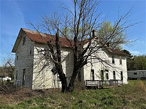
The former Masonic Lodge in 2024
|
|

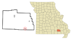
Location of Grandin, Missouri
|
|
| Country | United States |
| State | Missouri |
| County | Carter |
| Area | |
| • Total | 0.40 sq mi (1.04 km2) |
| • Land | 0.40 sq mi (1.04 km2) |
| • Water | 0.00 sq mi (0.00 km2) |
| Elevation | 581 ft (177 m) |
| Population
(2020)
|
|
| • Total | 226 |
| • Density | 565.00/sq mi (217.90/km2) |
| Time zone | UTC-6 (Central (CST)) |
| • Summer (DST) | UTC-5 (CDT) |
| ZIP code |
63943
|
| Area code(s) | 573 |
| FIPS code | 29-28180 |
| GNIS feature ID | 2394956 |
Grandin is a small city located in Carter County, Missouri, in the United States. In 2020, about 226 people lived there. It's a quiet place with a rich history tied to the lumber industry.
Contents
History of Grandin
Grandin was officially planned and laid out in 1910. Before that, it was a "company town" for the Missouri Lumber and Mining Company. A company town is a place where a company built homes and stores for its workers. This one started in the late 1880s.
The town got its name from E. B. Grandin, who was an important person in the local lumber business. A post office has been open in Grandin since 1887, helping people send and receive mail for a very long time.
In 1980, many important buildings in Grandin were added to the National Register of Historic Places. This list helps protect places that are special because of their history or architecture. These included 24 buildings, the Mill Pond, and the Sixth Street Historic District.
Geography of Grandin
Grandin is located in Missouri at these coordinates: 36°49′47″N 90°49′24″W / 36.829755°N 90.823417°W.
The city covers a total area of about 0.40 square miles (1.04 square kilometers). All of this area is land, meaning there are no large lakes or rivers within the city limits.
People of Grandin
The number of people living in Grandin has changed over the years. Here's how the population has looked during different census counts:
| Historical population | |||
|---|---|---|---|
| Census | Pop. | %± | |
| 1890 | 579 | — | |
| 1930 | 309 | — | |
| 1940 | 294 | −4.9% | |
| 1950 | 263 | −10.5% | |
| 1960 | 259 | −1.5% | |
| 1970 | 243 | −6.2% | |
| 1980 | 265 | 9.1% | |
| 1990 | 233 | −12.1% | |
| 2000 | 236 | 1.3% | |
| 2010 | 243 | 3.0% | |
| 2020 | 226 | −7.0% | |
| U.S. Decennial Census | |||
Grandin's Population in 2010
In 2010, the census showed that 243 people lived in Grandin. There were 102 households, which are groups of people living together in one home. Out of these, 60 were families.
The city had about 607 people per square mile (234 people per square kilometer). Most of the people living in Grandin were White (99.59%). A small number were Native American (0.41%). About 2.06% of the population identified as Hispanic or Latino.
Many households (35.3%) had children under 18 living with them. About 39.2% were married couples. Some households had a female head (15.7%) or a male head (3.9%) without a spouse. About 41.2% of households were not families.
The average age of people in Grandin in 2010 was 37.6 years old.
- 28% of residents were under 18.
- 11.2% were between 18 and 24.
- 22.3% were between 25 and 44.
- 23.5% were between 45 and 64.
- 15.2% were 65 years or older.
The population was almost evenly split between males (50.6%) and females (49.4%).
Education in Grandin
Grandin has a public library where people can borrow books. It is a part of the Carter County Library system.
See also
 In Spanish: Grandin (Misuri) para niños
 | William M. Jackson |
 | Juan E. Gilbert |
 | Neil deGrasse Tyson |

