Reynolds County, Missouri facts for kids
Quick facts for kids
Reynolds County
|
|
|---|---|

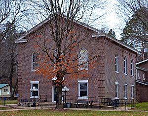
The antebellum county courthouse in Centerville
|
|

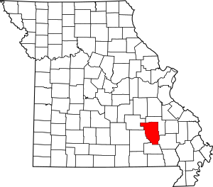
Location within the U.S. state of Missouri
|
|
 Missouri's location within the U.S. |
|
| Country | |
| State | |
| Founded | February 25, 1845 |
| Named for | Thomas Reynolds |
| Seat | Centerville |
| Largest city | Ellington |
| Area | |
| • Total | 814 sq mi (2,110 km2) |
| • Land | 808 sq mi (2,090 km2) |
| • Water | 5.9 sq mi (15 km2) 0.7% |
| Population
(2020)
|
|
| • Total | 6,096 |
| • Density | 7.489/sq mi (2.8915/km2) |
| Time zone | UTC−6 (Central) |
| • Summer (DST) | UTC−5 (CDT) |
| Congressional district | 8th |
Reynolds County is a county located in the Ozark Foothills region of Missouri. In 2020, about 6,096 people lived there. Its county seat (main town) is Centerville.
The county was officially started on February 25, 1845. It was named after Thomas Reynolds, who was a former governor of Missouri. Reynolds County is also home to Johnson's Shut-Ins State Park, a very popular place for visitors in Missouri.
Contents
History of Reynolds County
Reynolds County officially began on February 25, 1845. It is known for its beautiful, rugged natural areas in the Ozark Highland. Before it became its own county, parts of Reynolds County belonged to other counties like Ripley County (formed in 1831) and Wayne County (formed in 1818). It was also once part of Washington County and Ste. Genevieve County.
The Reynolds County Courthouse, where important county records are kept, has burned down twice. The first time was in December 1863, when the Confederate army set it on fire during the American Civil War. A new courthouse was built in 1867 on the same spot.
However, this new courthouse also burned down in November 1871. Both times, all the county records were lost. A temporary office building also caught fire in May 1872, while a new "fireproof" courthouse was being built.
Geography of Reynolds County
Reynolds County covers a total area of about 814 square miles. Most of this area, about 808 square miles, is land. The remaining 5.9 square miles (less than 1%) is water.
Neighboring Counties
Reynolds County shares borders with several other counties:
- Dent County (to the northwest)
- Iron County (to the northeast)
- Wayne County (to the southeast)
- Carter County (to the south)
- Shannon County (to the west)
Main Roads in Reynolds County
These are the major highways that run through Reynolds County:
Protected Natural Areas
A part of the Mark Twain National Forest is located within Reynolds County. This is a large area of protected forest land.
Natural Features
Reynolds County has several interesting natural features, including:
- Robinson Hollow
- Pogue Hollow
Population of Reynolds County
| Historical population | |||
|---|---|---|---|
| Census | Pop. | %± | |
| 1850 | 1,849 | — | |
| 1860 | 3,173 | 71.6% | |
| 1870 | 3,756 | 18.4% | |
| 1880 | 5,722 | 52.3% | |
| 1890 | 6,803 | 18.9% | |
| 1900 | 8,161 | 20.0% | |
| 1910 | 9,592 | 17.5% | |
| 1920 | 10,106 | 5.4% | |
| 1930 | 8,923 | −11.7% | |
| 1940 | 9,370 | 5.0% | |
| 1950 | 6,918 | −26.2% | |
| 1960 | 5,161 | −25.4% | |
| 1970 | 6,106 | 18.3% | |
| 1980 | 7,230 | 18.4% | |
| 1990 | 6,661 | −7.9% | |
| 2000 | 6,689 | 0.4% | |
| 2010 | 6,696 | 0.1% | |
| 2020 | 6,096 | −9.0% | |
| U.S. Decennial Census 1790-1960 1900-1990 1990-2000 2010-2015 |
|||
In 2000, there were 6,689 people living in Reynolds County. The population density was about 8 people per square mile. Most of the people living in the county were White (95.65%). There were also smaller numbers of Black or African American, Native American, and Asian residents. About 0.82% of the population was Hispanic or Latino.
The average age of people in the county in 2000 was 41 years old. About 24% of the population was under 18 years old.
Religion in Reynolds County
Reynolds County is part of what is known as the "Bible Belt." This means that many people in the area follow evangelical Protestant religions. The most common religious groups in Reynolds County are Southern Baptists, Baptist Missionary Association of America, and Methodists.
2020 Census Information
The 2020 census showed the following racial makeup for Reynolds County:
| Race | Number | Percent |
|---|---|---|
| White (not Hispanic) | 5,669 | 93% |
| Black or African American (not Hispanic) | 33 | 0.54% |
| Native American (not Hispanic) | 23 | 0.38% |
| Asian (not Hispanic) | 18 | 0.3% |
| Pacific Islander (not Hispanic) | 2 | 0.03% |
| Other/Mixed (not Hispanic) | 252 | 4.13% |
| Hispanic or Latino | 99 | 1.62% |
Education in Reynolds County
In Reynolds County, about 40.4% of adults aged 25 and older have a high school diploma or higher. About 10% have a bachelor's degree or higher.
Public Schools
The county has several public school districts:
- Bunker R-III School District in Bunker
- Bunker Elementary School (Kindergarten to 6th grade)
- Bunker High School (7th to 12th grade)
- Centerville R-I School District in Centerville
- Centerville Elementary School (Kindergarten to 8th grade)
- Lesterville R-IV School District in Lesterville
- Lesterville Elementary School (Kindergarten to 6th grade)
- Lesterville High School (7th to 12th grade)
- Lesterville Ranch Campus (Kindergarten to 12th grade) in Black
- Southern Reynolds County R-II School District in Ellington
- Southern Reynolds County Elementary School (Pre-Kindergarten to 5th grade)
- Southern Reynolds County High School (6th to 12th grade)
Public Libraries
- Reynolds County Library District
Communities in Reynolds County
Cities
- Bunker
- Centerville (This is the county seat)
- Ellington
Unincorporated Communities
These are smaller towns or areas that are not officially organized as cities:
See also
 In Spanish: Condado de Reynolds para niños
 | Madam C. J. Walker |
 | Janet Emerson Bashen |
 | Annie Turnbo Malone |
 | Maggie L. Walker |

