Wayne County, Missouri facts for kids
Quick facts for kids
Wayne County
|
|
|---|---|

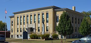
Wayne County Courthouse in Greenville
|
|

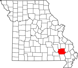
Location within the U.S. state of Missouri
|
|
 Missouri's location within the U.S. |
|
| Country | |
| State | |
| Founded | December 11, 1818 |
| Named for | Anthony Wayne |
| Seat | Greenville |
| Largest city | Piedmont |
| Area | |
| • Total | 774 sq mi (2,000 km2) |
| • Land | 759 sq mi (1,970 km2) |
| • Water | 15 sq mi (40 km2) 1.9% |
| Population
(2020)
|
|
| • Total | 10,974 |
| • Density | 14.178/sq mi (5.474/km2) |
| Time zone | UTC−6 (Central) |
| • Summer (DST) | UTC−5 (CDT) |
| Congressional district | 8th |
Wayne County is a county located in the Ozark foothills in the U.S. state of Missouri. In 2020, about 10,974 people lived here. The main town, or county seat, is Greenville.
The county was officially started on December 11, 1818. It is named after General "Mad" Anthony Wayne. He was a hero in the American Revolution. Fun fact: Since August 28, 2023, Wayne County and the city of Piedmont are known as the UFO Capital of Missouri!
Contents
History of Wayne County
Wayne County was created in December 1818. It was formed from parts of Cape Girardeau and Lawrence counties. This means Wayne County existed even before Missouri became a state!
In 1819, a large part of Lawrence County became part of the new Arkansas Territory. A small piece that was left out was added to Wayne County in 1820. By 1825, Wayne County grew even bigger. Between 1825 and 1831, it was larger than four states combined: Massachusetts, Connecticut, Rhode Island, and Delaware. Today, parts of 32 different Missouri counties used to be part of Wayne County.
When Wayne County was first formed, five leaders were chosen to govern it. They picked a small place called Cedar Cabin to be the county seat. This town was later renamed Greenville. By the early 1900s, about 1,000 people lived there.
However, in 1941, the people of Greenville had to move. This was because Lake Wappapello was being built. The new town of Greenville had fewer people at first, but its population has grown to about 563 today.
The Wayne County Courthouse, where important records are kept, has had a tough history. It burned down in 1854 and again in 1892. Also, in 1866, some records were stolen. Because of this, not many old county records still exist.
Geography of Wayne County
Wayne County covers about 774 square miles. Most of this area, about 759 square miles, is land. The rest, about 15 square miles, is water.
The biggest town in Wayne County is Piedmont, with about 2,401 people. Next is Greenville (563 people), and then Williamsville (386 people).
Counties Nearby
Wayne County shares borders with these other counties:
- Madison County (north)
- Bollinger County (east)
- Stoddard County (southeast)
- Butler County (south)
- Carter County (southwest)
- Reynolds County (west)
- Iron County (northwest)
Main Roads
These are the most important roads that go through Wayne County:
Protected Natural Areas
Parts of these national protected areas are in Wayne County:
People of Wayne County
| Historical population | |||
|---|---|---|---|
| Census | Pop. | %± | |
| 1820 | 1,443 | — | |
| 1830 | 3,264 | 126.2% | |
| 1840 | 3,403 | 4.3% | |
| 1850 | 4,518 | 32.8% | |
| 1860 | 5,629 | 24.6% | |
| 1870 | 6,068 | 7.8% | |
| 1880 | 9,096 | 49.9% | |
| 1890 | 11,927 | 31.1% | |
| 1900 | 15,309 | 28.4% | |
| 1910 | 15,181 | −0.8% | |
| 1920 | 13,012 | −14.3% | |
| 1930 | 12,243 | −5.9% | |
| 1940 | 12,794 | 4.5% | |
| 1950 | 10,514 | −17.8% | |
| 1960 | 8,638 | −17.8% | |
| 1970 | 8,546 | −1.1% | |
| 1980 | 11,277 | 32.0% | |
| 1990 | 11,543 | 2.4% | |
| 2000 | 13,259 | 14.9% | |
| 2010 | 13,521 | 2.0% | |
| 2020 | 10,974 | −18.8% | |
| U.S. Decennial Census 1790-1960 1900-1990 1990-2000 2010-2015 |
|||
In 2010, there were 13,521 people living in Wayne County. There were 5,717 households, which are groups of people living together. The county had about 18 people per square mile.
Most people in the county (97%) were White. A small number were Black or African American (0.7%), Native American (0.4%), or Asian (0.1%). About 1.5% of the people were Hispanic or Latino.
The most common backgrounds reported by people in Wayne County were American (32.9%), German (15.0%), English (11.9%), and Irish (11.7%).
In 2010, about 23.2% of households had children under 18 living there. About 52.7% were families with a husband and wife. The average household had 2.34 people.
The population was spread out by age. About 23.1% were under 19 years old. The median age was 45.8 years.
The average income for a household in the county was $33,954. For families, it was $39,419. About 23% of the population lived below the poverty line. This included 31.9% of those under 18.
Religion in Wayne County
Wayne County is part of an area called the Bible Belt. Most people who follow a religion here are evangelical Protestants. The largest groups are Southern Baptists (62.76%), Methodists (10.08%), and Roman Catholics (7.07%).
2020 Census Information
| Race | Num. | Perc. |
|---|---|---|
| White (NH) | 10,093 | 92% |
| Black or African American (NH) | 50 | 0.45% |
| Native American (NH) | 67 | 0.6% |
| Asian (NH) | 23 | 0.21% |
| Pacific Islander (NH) | 5 | 0.05% |
| Other/Mixed (NH) | 581 | 5.3% |
| Hispanic or Latino | 155 | 1.41% |
Education in Wayne County
In Wayne County, about 87% of adults aged 25 and older have a high school diploma or higher. Also, 30.3% have a bachelor's degree or higher.
Public Schools
- Clearwater R-I School District - Piedmont
- Clearwater Elementary School (Grades PK-4)
- Clearwater Middle School (Grades 5-8)
- Clearwater High School (Grades 9-12)
- Greenville R-II School District - Greenville
- Williamsville Elementary School (Grades PK-6) - Williamsville
- Greenville Elementary School (Grades PK-6)
- Greenville Jr. High School (Grades 7-8)
- Greenville High School (Grades 9-12)
Private Schools
- Victory Baptist Academy - Piedmont - (Grades PK-11) - A Baptist school
- New Hope Christian Academy - Silva - (Grades PK-12) - A Baptist school
Public Libraries
- Piedmont Public Library
- Greenville Community Library Greenville, Missouri
Communities in Wayne County
Cities
- Greenville (the county seat)
- Piedmont
- Williamsville
Village
Unincorporated Communities
These are smaller communities that are not officially cities or villages:
Ghost Towns
See also
 In Spanish: Condado de Wayne (Misuri) para niños
 | Mary Eliza Mahoney |
 | Susie King Taylor |
 | Ida Gray |
 | Eliza Ann Grier |

