Iron County, Missouri facts for kids
Quick facts for kids
Iron County
|
|
|---|---|

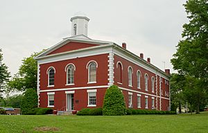
County courthouse in Ironton
|
|

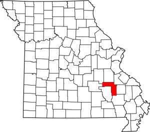
Location within the U.S. state of Missouri
|
|
 Missouri's location within the U.S. |
|
| Country | |
| State | |
| Founded | February 17, 1857 |
| Named for | Iron ore |
| Seat | Ironton |
| Largest city | Ironton |
| Area | |
| • Total | 552 sq mi (1,430 km2) |
| • Land | 550 sq mi (1,400 km2) |
| • Water | 1.8 sq mi (5 km2) 0.3% |
| Population
(2020)
|
|
| • Total | 9,537 |
| • Density | 17.277/sq mi (6.671/km2) |
| Time zone | UTC−6 (Central) |
| • Summer (DST) | UTC−5 (CDT) |
| Congressional district | 8th |
Iron County is a county in the U.S. state of Missouri. It is part of the Lead Belt region. In 2020, about 9,537 people lived here. The biggest city and the county seat (where the county government is) is Ironton. Iron County was officially started on February 17, 1857. It got its name because there was a lot of iron ore found in the area.
Iron County is home to the Arcadia Valley, which is about 6 miles (9.7 km) long and 2 miles (3.2 km) wide. This valley includes towns like Pilot Knob, Ironton, and Arcadia. These towns were built by immigrants in the 1800s. The valley is surrounded by the Saint Francois Mountains, which are part of the Ozarks Plateau. Iron County also has many mountains, including Taum Sauk Mountain. At 1,772 feet (540 m), it is the highest point in Missouri.
The county has several state parks and historical sites. These include Taum Sauk Mountain State Park, Elephant Rocks State Park, and Fort Davidson State Historic Site. A large part of the Mark Twain National Forest, about 96,047 acres (388.7 km²), is also in Iron County.
Contents
Geography of Iron County
Iron County covers a total area of 552 square miles (1,430 km²). Most of this, 550 square miles (1,420 km²), is land. Only a small part, 1.8 square miles (4.7 km²), is water.
Neighboring Counties
Iron County shares borders with several other counties:
- Washington County (north)
- St. Francois County (northeast)
- Madison County (east)
- Wayne County (southeast)
- Reynolds County (southwest)
- Dent County (west)
- Crawford County (northwest)
Protected Natural Areas
Population and People
| Historical population | |||
|---|---|---|---|
| Census | Pop. | %± | |
| 1860 | 5,842 | — | |
| 1870 | 6,278 | 7.5% | |
| 1880 | 8,183 | 30.3% | |
| 1890 | 9,119 | 11.4% | |
| 1900 | 8,716 | −4.4% | |
| 1910 | 8,563 | −1.8% | |
| 1920 | 9,458 | 10.5% | |
| 1930 | 9,642 | 1.9% | |
| 1940 | 10,440 | 8.3% | |
| 1950 | 9,458 | −9.4% | |
| 1960 | 8,041 | −15.0% | |
| 1970 | 9,529 | 18.5% | |
| 1980 | 11,084 | 16.3% | |
| 1990 | 10,726 | −3.2% | |
| 2000 | 10,697 | −0.3% | |
| 2010 | 10,630 | −0.6% | |
| 2020 | 9,537 | −10.3% | |
| U.S. Decennial Census 1790-1960 1900-1990 1990-2000 2010-2015 2020 |
|||
In 2020, the population of Iron County was 9,537 people. Most people living in Iron County are White. A smaller number are Black or African American, Native American, or Asian. Some people are of mixed races or are Hispanic or Latino.
Religious Beliefs
Iron County is part of the Bible Belt. This means that many people here follow evangelical Protestantism. The most common Christian groups are Southern Baptists, Methodists, and Roman Catholics.
Education in Iron County
Many adults in Iron County have a high school diploma. A smaller number have a bachelor's degree or higher from a college.
Public Schools
- Arcadia Valley School District in Ironton
- Arcadia Valley Elementary School (Grades PK-4)
- Arcadia Valley Middle School (Grades 5-8)
- Arcadia Valley High School (Grades 9-12)
- Belleview R-III Elementary School in Belleview (Grades K-8)
- [Iron County C-4 School District] in Viburnum
- Viburnum Elementary School (Grades K-6)
- Viburnum High School (Grades 7-12)
- [South Iron County R-I School District] in Annapolis
- South Iron County Elementary School (Grades PK-6)
- South Iron County High School (Grades 7-12)
Vocational and Technical Schools
- Arcadia Valley Career Technical Center in Ironton (Grades 9-12)
Public Libraries
- Ozark Regional Library
Transportation
Main Roads
Railroads
The Iron Mountain Railroad runs through Arcadia Valley. This railroad later became part of the Union Pacific. The train station in Arcadia is a stop for Amtrak's Texas Eagle train.
Towns and Communities
Cities and Towns
Smaller Communities (Unincorporated)
See also
 In Spanish: Condado de Iron (Misuri) para niños
 | Selma Burke |
 | Pauline Powell Burns |
 | Frederick J. Brown |
 | Robert Blackburn |

