
Taum Sauk Mountain facts for kids
Quick facts for kids Taum Sauk Mountain |
|
|---|---|

Taum Sauk Mountain is part of a large parks-and-wilderness area.
|
|
| Highest point | |
| Elevation | 1,772 ft (540 m) |
| Prominence | 512 ft (156 m) |
| Listing | U.S. state high point 41st |
| Geography | |

Taum Sauk Mountain
Location in Missouri
|
|
| Parent range | Saint Francois Mountains |
| Topo map | USGS Ironton |
| Climbing | |
| Easiest route | Hike |
Taum Sauk Mountain is the highest natural point in the state of Missouri. It is located in the Saint Francois Mountains. The mountain reaches a height of 1,772 feet (540 meters).
Instead of a sharp peak, Taum Sauk Mountain is shaped like a long ridge. This ridge runs from the north-northwest to the south-southeast.
Contents
What Makes Taum Sauk Mountain Special?
Even though Taum Sauk Mountain is not as tall as some other mountains, it is a true mountain. It was formed by ancient volcanoes. Most of the Ozarks region was shaped by erosion (wearing away of rock). But the Saint Francois Mountains, including Taum Sauk, were pushed up by volcanic activity.
How Old is Taum Sauk Mountain?
The Saint Francois Mountains are very old. They formed during the Precambrian time, which was billions of years ago. This makes them much older than the Appalachian Mountains. Geologists, who study rocks and the Earth, believe that Taum Sauk and its nearby mountains might be some of the only places in the United States that were never covered by ancient seas.
For most of the Paleozoic Era, these mountain peaks were like islands in a shallow ocean. Over time, sandstone, limestone, and shale rocks formed around them. The wearing away of these old mountains helped create the rock layers we see today.
Who Was Taum Sauk Named After?
The mountain is believed to be named after a Piankeshaw chief. His name was Sauk-Ton-Qua.
Is Taum Sauk the Most Prominent Mountain?
While Taum Sauk Mountain is the highest point in Missouri, it is not the most "prominent." Prominence means how much a mountain rises from its base. Taum Sauk rises about 522 feet from an already high area.
Other mountains in Missouri have a greater rise from their base:
- Mudlick Mountain rises 693 feet from a lower base. It reaches an elevation of 1,313 feet.
- Black Mountain in Madison County has the biggest rise in elevation in Missouri. It rises almost 1,000 feet from the St. Francis River valley to its top.
Taum Sauk Mountain State Park

In 1991, Missouri created Taum Sauk Mountain State Park. This park covers about 7,448 acres (30.14 square kilometers) on the mountain. It is a great place for outdoor activities.
What Can You Do at the Park?
- Camping: The park has a simple campground.
- Highpoint Trail: There is a paved trail that leads to the highest point. A polished granite plaque marks this spot.
- Lookout Tower: You can climb a lookout tower for amazing views. The dense forest on the mountain usually blocks the view from other spots.
Taum Sauk State Park works together with the nearby Johnson's Shut-ins State Park. Together, they form the second largest state park in Missouri, covering over 15,961 acres (64.59 square kilometers). These parks, along with the Bell Mountain Wilderness Area, create a large wilderness area. It is very popular with hikers and backpackers.
The Ozark Trail
The Taum Sauk section of the Ozark Trail is about 33 miles (53 kilometers) long. The Ozark Trail Association considers it one of the best trails in Missouri.
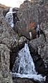
Mina Sauk Falls
Mina Sauk Falls is the highest waterfall in Missouri. It is located on Taum Sauk Mountain. You can reach it by hiking a rugged 3-mile (4.8-kilometer) loop trail from the highpoint parking area. These falls usually have water flowing over them only when there has been a lot of rain. At other times, they might just be a trickle or even dry.
Taum Sauk Hydroelectric Plant
The Taum Sauk pumped storage plant is not actually on Taum Sauk Mountain. It is on Proffit Mountain, about five miles (8 kilometers) southwest. This plant had a failure on December 14, 2005. It sent a flash flood 20 feet (6 meters) deep down the Black River.

Images for kids
-
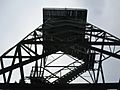
Taum Sauk lookout tower.
-
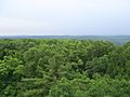
View from lookout tower.
-
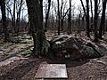
The highest natural point in the U.S. state of Missouri at 1,772 feet.
-
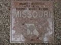
Granite plaque placed by the Missouri Association of Registered Land Surveyors
-
Mina Sauk Falls, the highest waterfall in Missouri.
.JPG)
.JPG)


