Williamsville, Missouri facts for kids
Quick facts for kids
Williamsville, Missouri
|
|
|---|---|

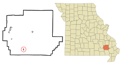
Location of Williamsville, Missouri
|
|
| Country | United States |
| State | Missouri |
| County | Wayne |
| Area | |
| • Total | 0.32 sq mi (0.84 km2) |
| • Land | 0.32 sq mi (0.84 km2) |
| • Water | 0.00 sq mi (0.00 km2) |
| Elevation | 400 ft (100 m) |
| Population
(2020)
|
|
| • Total | 279 |
| • Density | 863.78/sq mi (333.15/km2) |
| Time zone | UTC-6 (Central (CST)) |
| • Summer (DST) | UTC-5 (CDT) |
| ZIP code |
63967
|
| Area code(s) | 573 |
| FIPS code | 29-80026 |
| GNIS feature ID | 2397321 |
Williamsville is a small city in Wayne County, Missouri, in the United States. It is located right next to the Black River. In 2020, the city had a population of 279 people.
History
Williamsville was officially planned and marked out in 1871. This happened when the railroad lines were extended to reach that area. A post office opened in Williamsville in 1873 and has been running ever since. The city's name most likely comes from William Williams, who was the first owner of the land where the town was built.
Geography
Williamsville is a small city. According to the United States Census Bureau, the city covers a total area of about 0.32 square miles (0.84 square kilometers). All of this area is land, with no water.
Population Facts
The number of people living in Williamsville has changed over the years. Here is a look at the population from different census counts:
| Historical population | |||
|---|---|---|---|
| Census | Pop. | %± | |
| 1880 | 184 | — | |
| 1890 | 435 | 136.4% | |
| 1900 | 215 | −50.6% | |
| 1910 | 477 | 121.9% | |
| 1920 | 448 | −6.1% | |
| 1930 | 428 | −4.5% | |
| 1940 | 511 | 19.4% | |
| 1950 | 492 | −3.7% | |
| 1960 | 412 | −16.3% | |
| 1970 | 398 | −3.4% | |
| 1980 | 418 | 5.0% | |
| 1990 | 391 | −6.5% | |
| 2000 | 379 | −3.1% | |
| 2010 | 342 | −9.8% | |
| 2020 | 279 | −18.4% | |
| U.S. Decennial Census | |||
A Look at 2010
In 2010, the census counted 342 people living in Williamsville. These people lived in 148 households, and 98 of these were families. The city had about 1069 people per square mile. There were also 188 housing units available.
Most of the people in Williamsville were White (98.2%). A small number were African American (0.3%) or Native American (0.3%). About 1.2% of the people were of two or more races. Less than 1% of the population was Hispanic or Latino.
Out of the 148 households:
- About 28% had children under 18 living with them.
- Nearly 45% were married couples living together.
- About 14% had a female head of the household with no husband.
- About 8% had a male head of the household with no wife.
- Roughly 34% were not families.
Almost 30% of all households had only one person living there. About 15% of households had someone aged 65 or older living alone. The average household had 2.31 people, and the average family had 2.80 people.
The average age of people in the city was 44.5 years.
- About 20% of residents were under 18.
- About 8% were between 18 and 24.
- About 23% were between 25 and 44.
- About 29% were between 45 and 64.
- About 20% were 65 years or older.
The population was almost evenly split between males (50.6%) and females (49.4%).
See also
 In Spanish: Williamsville (Misuri) para niños
 | Aaron Henry |
 | T. R. M. Howard |
 | Jesse Jackson |

