
Stoddard County, Missouri facts for kids
Quick facts for kids
Stoddard County
|
|
|---|---|

The Stoddard County Courthouse in Bloomfield
|
|

Location within the U.S. state of Missouri
|
|
 Missouri's location within the U.S. |
|
| Country | |
| State | |
| Founded | January 2, 1835 |
| Named for | Amos Stoddard |
| Seat | Bloomfield |
| Largest city | Dexter |
| Area | |
| • Total | 829 sq mi (2,150 km2) |
| • Land | 823 sq mi (2,130 km2) |
| • Water | 5.8 sq mi (15 km2) 0.7% |
| Population
(2020)
|
|
| • Total | 28,672 |
| • Density | 34.586/sq mi (13.354/km2) |
| Time zone | UTC−6 (Central) |
| • Summer (DST) | UTC−5 (CDT) |
| Congressional district | 8th |
Stoddard County is a special area in the southeastern part of Missouri, a state in the United States. It's like a big neighborhood with its own local government.
In 2020, about 28,672 people lived here. The main town, or county seat, is Bloomfield. This is where the county's government offices are.
Stoddard County was officially created on January 2, 1835. It was named after Amos Stoddard. He was the first American leader, called a commandant, of a large area known as Upper Louisiana.
Contents
About Stoddard County's Land
Stoddard County covers a total area of about 829 square miles. Most of this area, 823 square miles, is land. The rest, about 5.8 square miles, is water. That means only a small part, less than 1%, is water!
Neighboring Counties
Stoddard County shares borders with several other counties:
- Bollinger County to the north
- Cape Girardeau County to the northeast
- Scott County to the northeast
- New Madrid County to the southeast
- Dunklin County to the south
- Butler County to the southwest
- Wayne County to the northwest
Main Roads
These are some of the important roads that go through Stoddard County:
 Future Interstate 57
 U.S. Route 60
 Route 25
 Route 51
 Route 153
Protected Natural Areas
Part of the Mingo National Wildlife Refuge is located in Stoddard County. This is a special place where nature is protected.
People and Population
| Historical population | |||
|---|---|---|---|
| Census | Pop. | %± | |
| 1840 | 3,153 | — | |
| 1850 | 4,277 | 35.6% | |
| 1860 | 7,877 | 84.2% | |
| 1870 | 8,535 | 8.4% | |
| 1880 | 13,431 | 57.4% | |
| 1890 | 17,327 | 29.0% | |
| 1900 | 24,669 | 42.4% | |
| 1910 | 27,807 | 12.7% | |
| 1920 | 29,755 | 7.0% | |
| 1930 | 27,452 | −7.7% | |
| 1940 | 33,009 | 20.2% | |
| 1950 | 33,463 | 1.4% | |
| 1960 | 29,490 | −11.9% | |
| 1970 | 25,771 | −12.6% | |
| 1980 | 29,009 | 12.6% | |
| 1990 | 28,895 | −0.4% | |
| 2000 | 29,705 | 2.8% | |
| 2010 | 29,968 | 0.9% | |
| 2020 | 28,672 | −4.3% | |
| U.S. Decennial Census 1790-1960 1900-1990 1990-2000 2010-2020 2020 |
|||
The population of Stoddard County has changed a lot over the years. You can see how it grew and shrank in the chart above.
In 2000, there were about 29,705 people living in the county. Most people were White (97.34%). A smaller number were Black or African American (0.91%), Native American (0.40%), or Asian (0.09%).
The average age of people in the county in 2000 was 39 years old. About 23.90% of the people were under 18 years old.
Religion in the County
Many people in Stoddard County are part of Christian churches. The most common groups are Southern Baptists, Methodists, and Pentecostals.
Schools and Learning
Stoddard County has many public schools for kids of all ages.
Public Schools
Here are some of the school districts in the county:
- Advance R-IV School District in Advance
- Advance Elementary School (Kindergarten to 6th grade)
- Advance High School (7th to 12th grade)
- Bell City R-II School District in Bell City
- Bell City Elementary School (Kindergarten to 6th grade)
- Bell City High School (7th to 12th grade)
- Bernie R-XIII School District in Bernie
- Bernie Elementary School (Preschool to 6th grade)
- Bernie High School (7th to 12th grade)
- Bloomfield R-XIV School District in Bloomfield
- Bloomfield Elementary School (Preschool to 5th grade)
- Bloomfield Middle School (6th to 8th grade)
- Bloomfield High School (9th to 12th grade)
- Dexter R-XI School District in Dexter
- Southwest Elementary School (Preschool to 2nd grade)
- Central Elementary School (3rd to 5th grade)
- T.S. Hill Middle School (6th to 8th grade)
- Dexter High School (9th to 12th grade)
- Puxico R-VIII School District in Puxico
- Puxico Elementary School (Preschool to 5th grade)
- Puxico Jr. High School (6th to 8th grade)
- Puxico High School (9th to 12th grade)
- Richland R-I School District in Essex
- Richland Elementary School (Kindergarten to 6th grade)
- Richland High School (7th to 12th grade)
Public Libraries
If you love to read, Stoddard County has several public libraries:
- Advance Community Library
- Bernie Public Library
- Bloomfield Public Library
- Keller Public Library
- Puxico Public Library
Towns and Villages
Stoddard County has several towns and smaller communities.
Cities
Villages
Other Communities
- Grayridge (This is a "census-designated place," meaning it's a community that the government counts as a separate place for population numbers.)
Small Unincorporated Communities
These are smaller places that don't have their own local government, but people still live there:
- Acorn Ridge
- Aid
- Aquilla
- Ardeola
- Asherville
- Avert
- Brownwood
- Buffington
- Bunker Hill
- Charter Oak
- Cobb
- Curdton
- Cyrus
- Durnell
- Frisco
- Guam
- Heagy
- Hunterville
- Idalia
- Idlewild
- Ives
- Kinder
- LaValle
- Leora
- Marco
- Maulsby
- Messler
- Mingo
- Painton
- Powe
- Pyletown
- Redd
- Shawan
- Shreve
- Stoddard
- Swinton
- Tillman
- Toga
- Toppertown
- Zadock
Images for kids
-
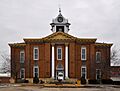
The Stoddard County Courthouse in Bloomfield
See also
 In Spanish: Condado de Stoddard para niños
