Bernie, Missouri facts for kids
Quick facts for kids
Bernie, Missouri
|
|
|---|---|

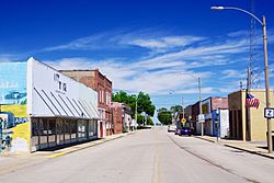
Main Street
|
|

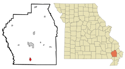
Location of Bernie, Missouri
|
|
| Country | United States |
| State | Missouri |
| County | Stoddard |
| Area | |
| • Total | 1.31 sq mi (3.39 km2) |
| • Land | 1.31 sq mi (3.39 km2) |
| • Water | 0.00 sq mi (0.00 km2) |
| Elevation | 305 ft (93 m) |
| Population
(2020)
|
|
| • Total | 1,859 |
| • Density | 1,421.25/sq mi (548.81/km2) |
| Time zone | UTC-6 (Central (CST)) |
| • Summer (DST) | UTC-5 (CDT) |
| ZIP code |
63822
|
| Area code(s) | 573 |
| FIPS code | 29-04960 |
| GNIS feature ID | 2394150 |
| Website | City of Bernie, Missouri |
Bernie is a small city located in the southern part of Stoddard County, in the state of Missouri, United States. In 2020, about 1,859 people lived there. It's a friendly place with a rich history.
Contents
A Look Back in Time: Bernie's History
Bernie was officially planned and settled in 1890. It got its name from a young girl named Bernice "Bernie" Crumb. She was the daughter of one of the first European-American settlers in the area.
A post office opened in Bernie in 1889, helping people send and receive mail. The city itself was officially formed in 1889. Bernie was an important stop along the St. Louis Southwestern Railway, which helped the town grow.
Where is Bernie Located?
Bernie is found almost in the area of Missouri known as the "Bootheel." This is a unique southeastern part of the state.
The city is about eight miles south of Dexter. It's also around nine miles north of Malden. You can find Bernie along Missouri Route 25. The St. Francis River is about ten miles to the west.
Bernie's Size and Land Area
According to the United States Census Bureau, Bernie covers a total area of about 1.31 square miles (3.39 square kilometers). All of this area is land, meaning there are no large lakes or rivers within the city limits.
Who Lives in Bernie? Population Facts
The population of Bernie has changed over the years. Here's how it has grown and shrunk:
| Historical population | |||
|---|---|---|---|
| Census | Pop. | %± | |
| 1900 | 333 | — | |
| 1910 | 742 | 122.8% | |
| 1920 | 1,571 | 111.7% | |
| 1930 | 1,031 | −34.4% | |
| 1940 | 1,160 | 12.5% | |
| 1950 | 1,308 | 12.8% | |
| 1960 | 1,578 | 20.6% | |
| 1970 | 1,641 | 4.0% | |
| 1980 | 1,975 | 20.4% | |
| 1990 | 1,847 | −6.5% | |
| 2000 | 1,777 | −3.8% | |
| 2010 | 1,958 | 10.2% | |
| 2020 | 1,859 | −5.1% | |
| U.S. Decennial Census | |||
Population Details from 2010
In 2010, there were 1,958 people living in Bernie. These people lived in 831 households, with 549 of them being families. The city had about 1,495 people per square mile.
Most people in Bernie were White (about 94.89%). There were also smaller groups of Black or African American people (2.20%), Native American people (0.61%), and Asian people (0.10%). Some people were from other races or had mixed racial backgrounds. About 1.43% of the population was Hispanic or Latino.
The average age of people in Bernie in 2010 was 40 years old. About 24.5% of the residents were under 18. About 17.3% were 65 years old or older.
Learning in Bernie: Schools and Library
The Bernie R-XIII School District is in charge of education in the city. It runs one elementary school for younger students. It also has Bernie Junior High/High School for older students.
The town also has a public library. The Bernie Public Library is a great place to borrow books and learn new things.
Famous People from Bernie
Bernie has been home to some notable people:
- Carl Edward Bailey was born in Bernie in 1894. He later became the 31st Governor of Arkansas and served from 1937 to 1941.
- Narvel Felts, a talented musician, attended Bernie High School. He is a member of the Rockabilly Hall of Fame.
- James Morton Smith was born in Bernie in 1919. He became the director of the Wisconsin Historical Society and the Winterthur Museum.
See also
 In Spanish: Bernie (Misuri) para niños
 | May Edward Chinn |
 | Rebecca Cole |
 | Alexa Canady |
 | Dorothy Lavinia Brown |

