
Scott County, Missouri facts for kids
Quick facts for kids
Scott County
|
|
|---|---|

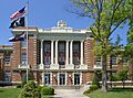
Scott County courthouse in Benton
|
|

Location within the U.S. state of Missouri
|
|
 Missouri's location within the U.S. |
|
| Country | |
| State | |
| Founded | December 28, 1821 |
| Named for | John Scott |
| Seat | Benton |
| Largest city | Sikeston |
| Area | |
| • Total | 426 sq mi (1,100 km2) |
| • Land | 420 sq mi (1,100 km2) |
| • Water | 5.9 sq mi (15 km2) 1.4% |
| Population
(2020)
|
|
| • Total | 38,059 |
| • Density | 89.34/sq mi (34.49/km2) |
| Time zone | UTC−6 (Central) |
| • Summer (DST) | UTC−5 (CDT) |
| Congressional district | 8th |
Scott County is a county in the southeastern part of Missouri, a U.S. state. In 2020, about 38,059 people lived there. The main town and county seat is Benton.
The county was started in 1821. It was named after John Scott, who was the first person to represent Missouri in the U.S. Congress. Scott County is part of the Sikeston, MO area. It is also included in the larger Cape Girardeau-Sikeston, MO-IL area. Scott County is home to Scott County Central High School. This school has won 18 state championships in boys basketball, which is more than any other high school in Missouri!
Contents
History of Scott County
Long ago, this area near the Mississippi River was home to indigenous peoples. The powerful Osage people lived in this large territory. Early French explorers came here in 1599. A Jesuit missionary named Father De Montigny put a cross on a rock island in the Mississippi River called Cape St. Croix. French traders later set up businesses with the Osage people. These traders were based in St. Louis, which was founded in the late 1700s.
Spain took control of the area in 1763 after France lost a war. In 1789, Spain built the King's Highway (El Camino Real). This was a major road that went north and south through the county and up to St. Louis. In the late 1790s, the first settlers from the United States arrived. They received land from Spain. France briefly took the land back. Then, in 1803, France sold it to the United States as part of the Louisiana Purchase.
In the 1820s, Delaware (also called Lenape) and Shawnee people moved into the area. They came from lands east of the Mississippi River. European-American settlers were moving onto their old lands.
Scott County was the second county created in Missouri's Southeast Lowland Region. The Missouri state legislature officially formed it on December 28, 1821. It was named for John Scott, who was Missouri's first congressman.
One of the first towns was Commerce, Missouri. It was known as Tywapitty, a name from the Osage language. It was an early French fur trading post. Before 1800, under Spanish rule, Rezin Bowie was in charge of the Tywappity Settlement. He was the brother of the famous frontiersman Jim Bowie. Commerce became a river landing by 1803. The first Baptist Church in Missouri was started here in 1805. The town was officially planned in 1823. It was the county seat of Scott County from 1864 to 1878.
The current county seat, Benton, was planned in 1822. It is named after Thomas Hart Benton. He was one of Missouri's first U.S. Senators.
New Hamburg was the third town founded in the county. German immigrants settled it in the late 1840s. They came to America after the German revolutions of 1848. The first church there was St. Lawrence Catholic Church. Sikeston is the largest city in the county. It was settled in 1800 and planned in 1860 by John Sikes. It was located along the Cairo & Fulton Railroad.
The county faced many guerrilla attacks during the U.S. Civil War. After the war, the county grew quickly from the 1870s to the early 1900s. Its thick forests were cut down for wood. Many railroads were also built. Towns founded during this time include Diehlstadt, Morley, Oran, Perkins, Blodgett, Crowder, Vanduser, Illmo, Fornfelt (now Scott City), Chaffee, Ancell, and Kelso. The Thebes-Mississippi River Railroad Bridge at Illmo was built in 1905.
Near Morley is the grave of Nathaniel W. Watkins. He was a state lawmaker and a general in the Missouri State Guards. He was also the half-brother of the famous statesman Henry Clay. Wilson Brown, who was the ninth lieutenant governor of Missouri, lived in the county for a while.
Farmers in Scott County grew cotton, soybeans, melons, and grains. Between the Mississippi River and the Little River District drainage ditches is Crowley’s Ridge. This is one of the oldest drainage systems in the United States, started in 1905. It is a leftover part of an old coastal floodplain.
On January 28, 2004, the Scott County Courthouse was added to the National Register of Historic Places. This means it is a special historical building.
Geography of Scott County
Scott County covers about 426 square miles (1,103 square kilometers). About 420 square miles (1,088 square kilometers) is land, and 5.9 square miles (15 square kilometers) is water. The county's eastern edge is the Mississippi River, which separates it from Illinois.
Counties Nearby
- Cape Girardeau County (northwest)
- Alexander County, Illinois (northeast)
- Mississippi County (southeast)
- New Madrid County (south)
- Stoddard County (southwest)
Main Roads
 Interstate 55
 Interstate 57
 U.S. Route 60
 U.S. Route 61
 U.S. Route 62
 Route 77
People of Scott County
| Historical population | |||
|---|---|---|---|
| Census | Pop. | %± | |
| 1830 | 2,136 | — | |
| 1840 | 5,974 | 179.7% | |
| 1850 | 3,182 | −46.7% | |
| 1860 | 5,247 | 64.9% | |
| 1870 | 7,317 | 39.5% | |
| 1880 | 8,587 | 17.4% | |
| 1890 | 11,228 | 30.8% | |
| 1900 | 13,092 | 16.6% | |
| 1910 | 22,372 | 70.9% | |
| 1920 | 23,409 | 4.6% | |
| 1930 | 24,913 | 6.4% | |
| 1940 | 30,377 | 21.9% | |
| 1950 | 32,842 | 8.1% | |
| 1960 | 32,748 | −0.3% | |
| 1970 | 33,250 | 1.5% | |
| 1980 | 39,647 | 19.2% | |
| 1990 | 39,376 | −0.7% | |
| 2000 | 40,422 | 2.7% | |
| 2010 | 39,191 | −3.0% | |
| 2020 | 38,059 | −2.9% | |
| U.S. Decennial Census 1790-1960 1900-1990 1990-2000 2010-2015 |
|||
In 2000, there were 40,422 people living in Scott County. There were 15,626 households and 11,219 families. The county had about 37 people per square mile.
Most people in the county were White (87.68%). About 10.50% were Black or African American. A small number were Native American, Asian, or from other groups. About 1.11% of the people were Hispanic or Latino.
About 35.40% of households had children under 18 living with them. The average household had 2.55 people. The average family had 3.03 people.
The population was spread out by age. About 27.40% were under 18. About 13.70% were 65 or older. The average age was 36 years old.
Religion in Scott County
Scott County is part of the Bible Belt. This means that many people here are evangelical Protestants. The most common religions are Southern Baptists (40.54%), Roman Catholics (27.12%), and Methodists (9.28%).
2020 Census Information
| Race | Num. | Perc. |
|---|---|---|
| White (NH) | 30,595 | 80.4% |
| Black or African American (NH) | 4,476 | 11.8% |
| Native American (NH) | 84 | 0.22% |
| Asian (NH) | 149 | 0.4% |
| Pacific Islander (NH) | 2 | 0.05% |
| Other/Mixed (NH) | 1,818 | 4.77% |
| Hispanic or Latino | 935 | 2.45% |
Education in Scott County
In Scott County, about 72.9% of adults aged 25 and older have a high school diploma or higher. About 10.6% have a bachelor's degree or higher.
Public Schools
- Chaffee R-II School District – Chaffee
- Chaffee Elementary School (Kindergarten-6th grade)
- Chaffee Jr.-Sr. High School (7th-12th grade)
- Oran R-III School District – Oran
- Oran Elementary School (Kindergarten-6th grade)
- Oran High School (7th-12th grade)
- Scott County R-IV School District – Benton
- Scott County Elementary School (Kindergarten-5th grade)
- Scott County Middle School (6th-8th grade)
- Thomas W. Kelly High School (9th-12th grade)
- Scott City R-I School District – Scott City
- Scott City Elementary School (Kindergarten-4th grade)
- Scott City Middle School (5th-8th grade)
- Scott City High School (9th-12th grade)
- Scott County Central School District – Sikeston
- Scott County Central Elementary School (Pre-Kindergarten-6th grade)
- Scott County Central High School (7th-12th grade)
- Sikeston R-VI School District – Sikeston
- Sikeston Kindergarten and Early Childhood Center (Pre-Kindergarten-Kindergarten)
- Lee Hunter Elementary (1st-4th grade)
- Southeast Elementary (1st-4th grade)
- Wing Elementary (1st-4th grade)
- Sikeston 5th & 6th Grade Center (5th-6th grade)
- Sikeston Jr. High School (7th-8th grade)
- Sikeston Sr. High School (9th-12th grade)
- Sikeston Alternative Education Center
- Sikeston Career and Technology Center
Private Schools
- St. Denis School – Benton – (1st-8th grade) – Roman Catholic
- St. Ambrose School – Chaffee – (Kindergarten-8th grade) – Roman Catholic
- St. Augustine School – Kelso – (1st-8th grade) – Roman Catholic
- Guardian Angel School – Oran – (Kindergarten-8th grade) – Roman Catholic
- St. Joseph School – Scott City – (Kindergarten-8th grade) – Roman Catholic
- St. Francis Xavier Christian Academy – Sikeston – (Pre-Kindergarten-8th grade) – Roman Catholic
- Southeast Missouri Christian Academy – Sikeston – (Pre-Kindergarten-Kindergarten) Daycare Center – Non-denominational Christian
- Solid Rock Christian Academy – Sikeston – Non-denominational Christian
Colleges and Universities
- Sikeston Area Higher Education Center (SAHEC) – Sikeston – This is a campus of Southeast Missouri State University.
- Sikeston Career & Technology Center – Sikeston – A school for learning job skills, part of the Sikeston R-VI School District.
- Three Rivers College – Sikeston
Public Libraries
- Chaffee Public Library
- Sikeston Public Library
Communities in Scott County
- Benton (county seat)
- Blodgett
- Chaffee
- Commerce
- Crowder
- Diehlstadt
- Haywood City
- Illmo
- Kelso
- Lambert
- Lusk
- Miner
- Morley
- New Hamburg
- Oran
- Perkins
- Rockview
- Salcedo
- Scott City
- Sikeston
- Tanner
- Vanduser
Images for kids
-
Scott County courthouse in Benton
See also
 In Spanish: Condado de Scott (Misuri) para niños
