
Sikeston, Missouri facts for kids
Quick facts for kids
Sikeston, Missouri
|
|
|---|---|

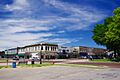
Downtown Sikeston
|
|

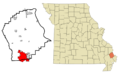
Location of Sikeston, Missouri
|
|
| Country | United States |
| State | Missouri |
| Counties | Scott, New Madrid |
| Government | |
| • Type | Mayor-Council |
| Area | |
| • Total | 17.30 sq mi (44.80 km2) |
| • Land | 17.14 sq mi (44.39 km2) |
| • Water | 0.16 sq mi (0.41 km2) |
| Elevation | 331 ft (101 m) |
| Population
(2020)
|
|
| • Total | 16,291 |
| • Density | 950.52/sq mi (367.01/km2) |
| Time zone | UTC-6 (Central (CST)) |
| • Summer (DST) | UTC-5 (CDT) |
| ZIP code |
63801
|
| Area code(s) | 573 |
| FIPS code | 29-67790 |
| GNIS feature ID | 2395885 |
| Website | http://www.sikeston.org/ |
Sikeston is a city in Missouri, United States. It is located in both Scott County and New Madrid County. Many people consider Sikeston part of the "Missouri Bootheel" region.
The city is easy to reach because it's near major highways like Interstate 55, Interstate 57, and U.S. Route 60. Sikeston is about halfway between the big cities of St. Louis and Memphis, Tennessee.
John Sikes founded the city in 1860, and it was named after him. Sikeston is the main city in its local area, which has a total population of about 41,143 people. In 2020, Sikeston itself had 16,291 residents.
Contents
- Sikeston's Past: A Look at History
- Sikeston's Location and Environment
- People of Sikeston: Demographics
- Sikeston's Economy and Jobs
- Arts, Culture, and Fun in Sikeston
- Parks and Recreation in Sikeston
- Learning in Sikeston: Education
- News and Media in Sikeston
- Getting Around: Transportation in Sikeston
- Staying Healthy: Healthcare in Sikeston
- Famous People from Sikeston
- Sikeston in Movies
- Sister City
- Images for kids
- See also
Sikeston's Past: A Look at History
The area where Sikeston now stands was once covered with swamps and forests. In the early 1900s, a huge project called the Little River Drainage District helped drain the land. This project moved more earth than the building of the Panama Canal!
Early Explorers and Settlements
In 1541, the Spanish explorer Hernando de Soto might have visited the Sikeston Ridge area. Later, France claimed this land as part of "La Louisiane." In 1763, France gave the land to Spain.
In 1789, the King of Spain ordered a road to be built. This road connected St. Louis and New Orleans. It was known as the El Camino Real, or "King's Highway."
United States Takes Over
The United States bought this land in 1803 as part of the Louisiana Purchase. More American settlers then moved west of the Mississippi River.
Between 1811 and 1812, the area was hit by the 1811–12 New Madrid earthquakes. These were a series of more than 2,000 earthquakes. Some believe they were the strongest in North American history.
The Hunter Memorial Cemetery was started around 1812 after the earthquakes. It is on the grounds of the local Presbyterian Church. Joseph Hunter II, who served in the American Revolutionary War, established it.
A village called Winchester was laid out in 1814, south of where Sikeston would be. It was the county seat for New Madrid County. But the county seat moved in 1822, and Winchester was abandoned.
Founding of Sikeston
The land for Sikeston was first owned by Francis Paquette. In 1859, John Sikes, who married into the Stallcup family, took control of the land. In April 1860, he planned the city. He expected the Cairo and Fulton Railroad to be completed and cross the King's Highway there.
Today, Kingshighway is a main street in Sikeston. It has many businesses and old homes. Malone Park, the city's oldest park, is in downtown Sikeston. You can also see the historic First Methodist Church columns. These six pillars are all that remain of the 1879 church, which burned down in 1968.
The first house in Sikeston was likely built in 1855. It was about five years before the town was officially founded. Lee Hunter, for whom an elementary school is named, lived in this house.
Sikeston During the Civil War
Even though Sikeston was a small village, its location was important during the American Civil War. It was at a key railroad and highway intersection.
In 1861, Confederate forces gathered near Sikeston. They planned to advance on St. Louis. Confederate General M. Jeff Thompson, known as the "Swamp Fox," was active in the area. He even robbed a bank to pay his troops!
Both Union and Confederate forces moved through Sikeston. In 1862, Union General Pope used Sikeston as a transportation hub. He moved artillery through the city for the Battle of Island Number Ten. Union troops also set up a garrison in Sikeston.
After the Civil War
One of the first rail lines west of the Mississippi River ended in Sikeston until 1872. By 1900, Sikeston had grown to 1,100 people. It had two banks, two newspapers, and three hotels. The Marshall-Dunn Hotel, built around 1895-1898, is now on the National Register of Historic Places. Famous people like Harry S. Truman stayed there.
Sikeston in the World Wars
During World War I, an infantry company from Sikeston was formed. Company K fought in Europe and was part of the occupation force.
Between the two world wars, Company K helped during the railroad workers' strike of 1922. They also assisted after the Poplar Bluff tornado in 1927. They worked on the Mississippi River levees during the floods of 1927 and 1937.
The Sikeston Memorial Municipal Airport opened in 1934. During World War II, it was a flight training center. Famous flying aces like Robert S. Johnson and Harold E. Comstock trained there. The original entrance to the airport is now the entrance to the city's Veterans Park.
Local students helped raise money for three B-25 bombers named after Sikeston. These planes were supposedly used in the Doolittle Raid. The local International Shoe Company factory also made shoes for the US Army during the war.
Recent History of Sikeston
After World War II, the nearby city of Miner was founded. It was named after one of the original landowners.
In 2000, the remains of Mason Yarbrough, a Sikeston Marine from World War II, were found. He was returned home for a military funeral. The George E. Day Parkway is named for Colonel George E. "Bud" Day. He was a Medal of Honor recipient and a POW during the Vietnam War.
Sikeston is also home to a National Guard unit. This unit, Company C 1140th Engineer Battalion, served in Operation Iraqi Freedom from 2004 to 2005.
Sikeston's Location and Environment
Sikeston is located on the Sikeston Ridge. This ridge runs north to south. Before 1927, the New Madrid-Sikeston Ridge Levee was built. It protected the area from floods from the Mississippi River.
The city covers about 17.48 square miles (44.80 square kilometers). Most of this area is land.
Weather Events in Sikeston
1986 Tornado
On May 15, 1986, a tornado hit Sikeston. It destroyed about 100 homes. The Governor of Missouri, John Ashcroft, visited the city and called for the National Guard to help.
2009 Ice Storm
In January 2009, Sikeston was hit by a severe ice storm. This storm caused power outages for many days. It also damaged a lot of trees. This was the worst natural disaster for the city since the 1986 tornado.
Climate in Sikeston
| Climate data for Sikeston, Missouri (1991–2020 normals, extremes 1950–present) | |||||||||||||
|---|---|---|---|---|---|---|---|---|---|---|---|---|---|
| Month | Jan | Feb | Mar | Apr | May | Jun | Jul | Aug | Sep | Oct | Nov | Dec | Year |
| Record high °F (°C) | 73 (23) |
78 (26) |
85 (29) |
93 (34) |
101 (38) |
110 (43) |
107 (42) |
106 (41) |
102 (39) |
95 (35) |
85 (29) |
74 (23) |
110 (43) |
| Mean daily maximum °F (°C) | 44.2 (6.8) |
49.2 (9.6) |
59.2 (15.1) |
70.6 (21.4) |
80.5 (26.9) |
88.8 (31.6) |
91.4 (33.0) |
90.3 (32.4) |
83.9 (28.8) |
72.6 (22.6) |
58.4 (14.7) |
47.7 (8.7) |
69.7 (20.9) |
| Daily mean °F (°C) | 36.0 (2.2) |
39.9 (4.4) |
48.9 (9.4) |
59.6 (15.3) |
69.9 (21.1) |
78.3 (25.7) |
81.0 (27.2) |
79.3 (26.3) |
72.0 (22.2) |
60.7 (15.9) |
48.6 (9.2) |
39.8 (4.3) |
59.5 (15.3) |
| Mean daily minimum °F (°C) | 27.8 (−2.3) |
30.7 (−0.7) |
38.7 (3.7) |
48.6 (9.2) |
59.3 (15.2) |
67.9 (19.9) |
70.7 (21.5) |
68.3 (20.2) |
60.2 (15.7) |
48.9 (9.4) |
38.9 (3.8) |
31.8 (−0.1) |
49.3 (9.6) |
| Record low °F (°C) | −10 (−23) |
−12 (−24) |
−4 (−20) |
24 (−4) |
31 (−1) |
46 (8) |
48 (9) |
41 (5) |
34 (1) |
19 (−7) |
2 (−17) |
−12 (−24) |
−12 (−24) |
| Average precipitation inches (mm) | 3.68 (93) |
4.25 (108) |
4.96 (126) |
5.50 (140) |
4.74 (120) |
4.26 (108) |
3.87 (98) |
3.32 (84) |
3.21 (82) |
3.57 (91) |
4.20 (107) |
4.08 (104) |
49.64 (1,261) |
| Average snowfall inches (cm) | 0.8 (2.0) |
1.2 (3.0) |
0.6 (1.5) |
0.0 (0.0) |
0.0 (0.0) |
0.0 (0.0) |
0.0 (0.0) |
0.0 (0.0) |
0.0 (0.0) |
0.1 (0.25) |
0.0 (0.0) |
0.4 (1.0) |
3.1 (7.9) |
| Average precipitation days (≥ 0.01 in) | 8.4 | 7.9 | 10.0 | 9.9 | 10.3 | 8.4 | 6.9 | 6.1 | 6.2 | 6.3 | 7.5 | 8.7 | 96.6 |
| Average snowy days (≥ 0.1 in) | 0.3 | 1.0 | 0.2 | 0.0 | 0.0 | 0.0 | 0.0 | 0.0 | 0.0 | 0.0 | 0.1 | 0.5 | 2.1 |
| Source: NOAA | |||||||||||||
People of Sikeston: Demographics
| Historical population | |||
|---|---|---|---|
| Census | Pop. | %± | |
| 1880 | 191 | — | |
| 1890 | 636 | 233.0% | |
| 1900 | 1,077 | 69.3% | |
| 1910 | 3,327 | 208.9% | |
| 1920 | 3,613 | 8.6% | |
| 1930 | 5,676 | 57.1% | |
| 1940 | 7,944 | 40.0% | |
| 1950 | 11,640 | 46.5% | |
| 1960 | 13,765 | 18.3% | |
| 1970 | 14,699 | 6.8% | |
| 1980 | 17,431 | 18.6% | |
| 1990 | 17,641 | 1.2% | |
| 2000 | 16,992 | −3.7% | |
| 2010 | 16,318 | −4.0% | |
| 2020 | 16,291 | −0.2% | |
| source: | |||
Sikeston's Population in 2020
The 2020 United States census counted 16,291 people living in Sikeston. There were 7,273 households. The city had about 950 people per square mile.
Most residents, about 64.42%, were white. About 27.7% were black or African-American. Other groups made up smaller percentages of the population. About 2.6% of the population was Hispanic or Latino.
About 25% of the people were under 18 years old. The average age in Sikeston was 40.4 years.
Sikeston's Population in 2010
In 2010, Sikeston had 16,318 people. There were 6,749 households. The population density was about 942 people per square mile.
The racial makeup was similar to 2020. About 69.95% were white, and 26.20% were black or African American. About 2.32% of the population was Hispanic or Latino.
About 25.1% of residents were under 18. The average age was 38.5 years.
Sikeston's Economy and Jobs
The cost of living in Sikeston is lower than the average for the U.S. This means it's generally less expensive to live there.
Major employers in Sikeston include Unilever, Missouri Delta Medical Center, the Sikeston Public Schools, and Wal-Mart.
Agriculture is very important in the area. Farmers grow crops like cotton, soybeans, corn, rice, and watermelons.
Montgomery Bank, a large family-owned bank in Missouri, has its main office in Sikeston. It started in 1903.
The Sikeston Board of Municipal Utilities provides electricity, water, and sewer services to the city. They operate a large coal-fired power plant.
Arts, Culture, and Fun in Sikeston
Sikeston is well-known for country music. Many famous performers have played at the local Jaycee rodeo. These include Kenny Rogers and Loretta Lynn. Kenny Rogers even donated an Arabian stallion to help a local children's center.
The Sikeston Missouri Arts Council and the Sikeston Art League offer concerts and art shows. The Sikeston Little Theater is the oldest performing arts group between St. Louis and Memphis.
Sikeston has a public library called the Sikeston Public Library.
Parks and Recreation in Sikeston
Sikeston has 16 parks for everyone to enjoy. The biggest is the Sikeston Recreation Complex. It has a fishing lake, picnic areas, and playgrounds. It also has courts for tennis and pickleball, and fields for soccer, baseball, and football. Many sports tournaments are held here.
Other parks include Armory Park, Central Park, and Veterans Park.
Sikeston is also home to VFW Stadium, a large baseball field. The Sikeston Depot is the city's museum. The American Legion-sponsored Cotton Carnival and Parade started in 1944. It was a way to welcome home World War II veterans. The parade is one of the biggest in Missouri.
Learning in Sikeston: Education
Most adults in Sikeston (73.3%) have a high school diploma or higher. About 14.2% have a bachelor's degree or more.
Public Schools in Sikeston
Sikeston has several public schools:
- Lee Hunter Elementary School
- Southeast Elementary School
- Wing Elementary
- Sikeston Middle High School
- Sikeston Junior High School
- Sikeston High School
Private Schools in Sikeston
There are four private schools in Sikeston:
- St. Francis Xavier Catholic School
- Solid Rock Christian Academy
- Southeast Missouri Christian Academy
- The Christian Academy
In 1892, a high school called the "Methodist College" was started. It closed after the public high school was established.
Higher Education and Technical Schools
For students who want to continue their education, Sikeston has:
- Southeast Missouri State University-Sikeston, a branch campus of Southeast Missouri State University.
- The Sikeston Career and Technology Center.
- Three Rivers Community College, a branch campus.
News and Media in Sikeston
The Sikeston Standard Democrat is the city's daily newspaper. It was formed from two older newspapers. The editor of The Daily Standard was even featured in Time Magazine in 1939!
Sikeston High School has its own newspaper, The Bulldog Barker. Their yearbook is called The Growler.
Getting Around: Transportation in Sikeston
In 1789, "The King's Highway" was created by order of the King of Spain. Today, this road is known as U.S. Route 61. A monument in Sikeston marks this historic event.
The city is served by the BNSF Railway.
Sikeston is unique because it's located at the intersection of two major interstate highways: I-55 and I-57. This makes it one of only a few cities in Missouri with this feature. Other highways in Sikeston include U.S. Route 60, U.S. Route 61, and U.S. Route 62.
Staying Healthy: Healthcare in Sikeston
Missouri Delta Medical Center was founded in Sikeston in 1948. This hospital has 200 beds and employs over 600 healthcare workers.
Famous People from Sikeston
Many notable individuals have connections to Sikeston.
Leaders and Public Servants
- Kenny Hulshof, a congressman.
- Maida Coleman, a state senator from St. Louis, was born in Sikeston.
- Charles Augustus Crow, a former congressman, was born near Sikeston.
- Alfred C. Sikes, who led the Federal Communications Commission.
- Peter C. Myers, a Deputy Secretary of Agriculture.
- George A. Russell, a former president of the University of Missouri System.
Military Heroes
- Harold E. Comstock, a World War II flying ace who trained in Sikeston.
- Clyde A. Vaughn, a lieutenant general in the Army National Guard.
- Wendul G. Hagler II, a major general.
Business and Community Leaders
- Gaylon M. Lawrence, a major agricultural landowner.
- Thornton Wilson, a former leader of Boeing, was born near Sikeston.
Sports Stars
- Charlie Babb, a professional football player.
- Brandon Barnes, a professional football player.
- Blake DeWitt, a professional baseball player.
- Eric Hurley, a professional baseball player.
- Otto Porter, Jr., a basketball player for the Golden State Warriors.
- James Wilder Sr., a professional football player.
- George Woods, an Olympic silver medalist in shot put.
Entertainers and Artists
- Jacqueline Scott, an actress who appeared in many TV shows, was born in Sikeston.
- Neal E. Boyd, a pop-opera singer and winner of America's Got Talent, was born in Sikeston.
Writers and Authors
- Ronald Anderson, a sociology professor and author.
- Richard B. Hoover, an author of many scientific papers.
- Jean Marie Stine, a writer and publisher.
- Terry Teachout, a critic and playwright.
- Robert Vaughan, an author of over 200 books, has lived in Sikeston.
Sikeston in Movies
Sikeston has been the setting for a few films. The movies Love Takes Wing and Love Finds a Home are set there.
The 1962 film The Intruder, starring William Shatner, had scenes filmed in downtown Sikeston.
Sister City
Sikeston has a sister city relationship with Yeosu, South Korea.
Images for kids
-
Downtown Sikeston
-
Location of Sikeston, Missouri
See also
 In Spanish: Sikeston (Misuri) para niños
