
Sikeston Ridge facts for kids
Sikeston Ridge is a raised area of land, about two miles (3 km) wide. It's like a long, flat-topped hill that was created by the Mississippi River. This happened a long time ago when the Mississippi River flowed west of Sikeston, in the United States.
This ridge runs south from Haywood City through Sikeston all the way to New Madrid, Missouri, a town on the Mississippi River. Another much bigger ridge nearby is Crowley's Ridge, which is 150 miles (240 km) long and about 400 feet (120 m) high.
Back in 1789, the King of Spain wanted a road built to connect the cities of St. Louis and New Orleans. A small part of this road was built on the high ground of Sikeston Ridge.
Before the swampy land around it was drained, Sikeston Ridge was a very important place during the early days of the American Civil War. Its higher ground made it a good spot for military control.
Contents
How Sikeston Ridge Was Formed
Scientists used to think Sikeston Ridge was much older. But after looking closely at the ground, they found that the dirt and sand on and around the ridge were mostly fine sand and mud. This meant that the layer of loess (a type of fine, wind-blown dust) on top was very thin.
This discovery made geomorphologists (scientists who study how landforms are made) realize the ridge was younger than they first thought. They now believe the sand on the ridge was left behind by rivers during a time called the Peoria Loess deposition. This fits with the idea that Sikeston Ridge is a leftover part of a "valley train" from the late Wisconsin glacial period. A valley train is like a long pile of sand and gravel left by a river flowing out of a melting glacier.
The sand deposits on Sikeston Ridge and other areas downstream match up. Scientists think they were all part of the same river system during the late Wisconsin glacial period. They figured out the ages of different land areas by drilling into the ground and comparing their heights. Areas with very little loess on top usually formed during the full glacial to early late glacial period.
Which River Formed It?
Even though scientists agree on the ridge's age, they are still not completely sure if the sand under Sikeston Ridge was left by the Ohio River or the Mississippi River.
They found special types of clay and silt (called slackwater facies) in the area. These are left behind when floodwaters flow back into a river system. This suggests that the Mississippi River was actively building up its bed (a process called aggrading) during the late Wisconsin full glacial period. This means Sikeston Ridge was likely a valley train built by the Mississippi River flowing through the Bell City–Oran Gap. However, other valley train areas to the east of Sikeston Ridge might have been formed by the Ohio River.
Not a Tectonic Ridge
Some people thought Sikeston Ridge might have been formed by tectonic forces (like earthquakes pushing land up) because it's located in the New Madrid Seismic Zone, an area known for earthquakes.
But studies, including digging trenches, drilling, and using satellite images along the western edge of the ridge, showed only very small changes underground. These changes were tiny compared to the ridge's height. So, scientists have decided that Sikeston Ridge was formed by erosion (water wearing away the land) and by material sliding down slopes (called colluvial deposition) and rivers cutting channels during the latest Wisconsin glacial period, which was part of the Pleistocene Ice Age. The wavy edges along the ridge also suggest that water wore it away in the past.
Where to Find Sikeston Ridge
Sikeston Ridge is a clear land feature in southeastern Missouri. As mentioned, it's in the New Madrid Seismic Zone, but it was not formed by earthquakes.
The Geographic Names Information System (GNIS) lists three main points along the ridge:
- 36°53′42″N 89°35′16″W / 36.89505°N 89.58786°W
- 36°48′50″N 89°34′29″W / 36.81394°N 89.57480°W
- 36°43′21″N 89°31′30″W / 36.72256°N 89.52508°W
Images for kids
-
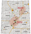
Map of New Madrid Seismic Zone

