
New Madrid, Missouri facts for kids
Quick facts for kids
New Madrid, Missouri
|
||
|---|---|---|

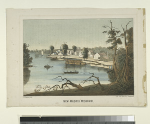
New Madrid, facing away from the Mississippi
|
||
|
||

Location of New Madrid, Missouri
|
||
| Country | United States | |
| State | Missouri | |
| County | New Madrid | |
| Area | ||
| • Total | 4.54 sq mi (11.75 km2) | |
| • Land | 4.50 sq mi (11.66 km2) | |
| • Water | 0.04 sq mi (0.09 km2) | |
| Elevation | 292 ft (89 m) | |
| Population
(2020)
|
||
| • Total | 2,787 | |
| • Density | 619.20/sq mi (239.05/km2) | |
| Time zone | UTC−6 (Central (CST)) | |
| • Summer (DST) | UTC−5 (CDT) | |
| ZIP code |
63869
|
|
| Area code(s) | 573/235 | |
| FIPS code | 29-52076 | |
| GNIS feature ID | 2395206 | |

New Madrid (say it like MAD-rid) is a city in New Madrid County, Missouri, United States. It's located in the central part of the United States. In 2020, about 2,787 people lived there. New Madrid is also the main town, or county seat, of New Madrid County.
The city sits on the north side of a big curve in the Mississippi River called the Kentucky Bend. This bend is also known as "New Madrid Bend." The river makes a loop around a piece of land that belongs to Kentucky. Scientists think the river might one day cut straight across this loop, turning the Kentucky land into an island!
New Madrid is famous for being the center of some very strong earthquakes that happened in 1811 and 1812.

Contents
History of New Madrid
Early Settlement and Spanish Rule
The first lasting settlement in New Madrid was started by groups of Shawnee, Delaware, Creek, and Cherokee people. They became refugees during the American War for Independence. In the early 1780s, these Native American groups accepted an offer from Spain. They settled on the west bank of the Mississippi River.
They set up a trading post where a horseshoe bend of the Mississippi River met Chepusa Creek. This spot was easy for boats to land. Native American hunters and European-American traders used the settlement to prepare animal fats from bears and buffalo. These fats were important for making skins and furs. The settlement was soon called L’Anse a la Graise, meaning "Cove of Grease."
Around 1780, European Americans renamed the settlement New Madrid. This happened under the Spanish Governor Bernardo de Gálvez. He was in charge of Spanish Louisiana, which was the land west of the Mississippi River. Manuel Pérez, the Lieutenant Governor in Saint Louis, also helped.
They welcomed settlers from the United States. However, these settlers had to promise to be loyal to the Spanish king. They also had to follow the guidance of Colonel George Morgan. He was an American Revolutionary War veteran from New Jersey. Morgan brought many American families to settle in New Madrid.
Challenges and Changes
Settlement in the 1790s and early 1800s stayed low. The Mississippi River often washed away the town's riverbanks. Even a Spanish fort was washed away by the river. New Madrid was surrounded by low, swampy land. This gave it a reputation for diseases, especially in the summer and fall.
Spanish records from the late 1790s show about 800 people living in New Madrid. The town continued to be a place where Native Americans and European American traders exchanged goods.
In 1800, Spain gave the territory back to France. This was part of the Third Treaty of San Ildefonso. Later, in 1803, France's leader Napoleon decided to sell this land to the United States. This big sale was known as the Louisiana Purchase.
Famous Earthquakes
The New Madrid area is famous for a series of powerful earthquakes. More than 1,000 earthquakes happened in 1811 and 1812. Some of these were as strong as magnitude 8. These were the most powerful earthquakes in the United States that were not near a plate boundary. New Madrid is far from plate boundaries. But it sits on the New Madrid Seismic Zone, a place where the Earth's crust is weak. The biggest earthquake was felt all the way on the East Coast.
Civil War and Beyond
During the Civil War, a battle called the Battle of Island Number Ten took place near New Madrid on the Mississippi River.
Before the Civil War, the rich, flat land around New Madrid was used for growing cotton. This work was done by enslaved African Americans. After the Civil War, they became free and worked to build new lives.
By the early 1900s, New Madrid started to have some industries. There were two lumber mills, a grist mill (for grinding grain), and factories that made wood parts. There was also a cotton gin for processing cotton. The town had four Protestant churches and one Catholic church. Two of the Protestant churches were for African-American groups.
Geography of New Madrid
New Madrid covers about 4.53 square miles (11.75 square kilometers). Most of this area is land, with a small part being water.
Climate
New Madrid has a humid subtropical climate. This means it has hot, humid summers and chilly, but not usually very cold, winters. The weather in winter can change a lot. Sometimes it's mild and rainy, and other times it's very cold and windy.
Rainfall is quite heavy throughout the year. This is because moist air from the Gulf of Mexico often comes into the area. Sometimes, storms that used to be hurricanes can also bring a lot of rain as they move up the Mississippi Valley. Snowfall is very rare in New Madrid.
Air Quality
A power plant near New Madrid, owned by Associated Electric Cooperative Inc., has been noted for its air pollution. This pollution includes Sulfur dioxide, which can affect the air quality in nearby communities.
Population of New Madrid
New Madrid's population has changed over the years. Here's how it has grown and shrunk:
| Historical population | |||
|---|---|---|---|
| Census | Pop. | %± | |
| 1860 | 610 | — | |
| 1870 | 634 | 3.9% | |
| 1880 | 712 | 12.3% | |
| 1890 | 1,193 | 67.6% | |
| 1900 | 1,489 | 24.8% | |
| 1910 | 1,882 | 26.4% | |
| 1920 | 1,908 | 1.4% | |
| 1930 | 2,309 | 21.0% | |
| 1940 | 2,450 | 6.1% | |
| 1950 | 2,726 | 11.3% | |
| 1960 | 2,867 | 5.2% | |
| 1970 | 2,719 | −5.2% | |
| 1980 | 3,204 | 17.8% | |
| 1990 | 3,350 | 4.6% | |
| 2000 | 3,334 | −0.5% | |
| 2010 | 3,116 | −6.5% | |
| 2020 | 2,787 | −10.6% | |
| source: | |||
2020 Census Information
In 2020, there were 2,787 people living in New Madrid. About 70% of the people were White, and about 28% were Black or African American. A small number of people were Native American, Asian, or from two or more races. About 3% of the population was Hispanic or Latino.
The average age of people in the city was 47.2 years old. About 15% of residents were under 18 years old. About 24% were between 25 and 44 years old. And about 24% were 65 years or older. The city had slightly more females than males.
Education
The New Madrid County R-I School District runs six schools in the New Madrid area. This includes New Madrid County Central high school.
New Madrid also has a public library. It is a branch of the New Madrid County Library.
Images for kids
-
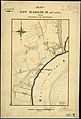
1865 map of New Madrid and Vicinity

See also
 In Spanish: Nueva Madrid para niños
