New Madrid County, Missouri facts for kids
Quick facts for kids
New Madrid County
|
|
|---|---|

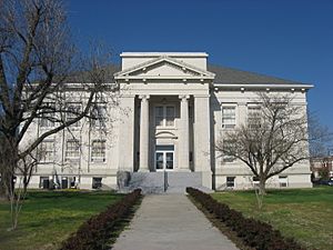
New Madrid County Courthouse
|
|

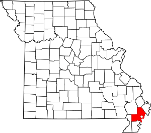
Location within the U.S. state of Missouri
|
|
 Missouri's location within the U.S. |
|
| Country | |
| State | |
| Founded | October 1, 1812 |
| Named for | Madrid, Spain |
| Seat | New Madrid |
| Largest city | Portageville |
| Area | |
| • Total | 697 sq mi (1,810 km2) |
| • Land | 675 sq mi (1,750 km2) |
| • Water | 22 sq mi (60 km2) 3.1% |
| Population
(2020)
|
|
| • Total | 16,434 |
| • Density | 23.578/sq mi (9.104/km2) |
| Time zone | UTC−6 (Central) |
| • Summer (DST) | UTC−5 (CDT) |
| Congressional district | 8th |
New Madrid County is a county in the U.S. state of Missouri. It's located in the "Bootheel" part of Missouri. In 2020, about 16,434 people lived here.
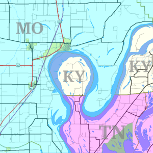
The biggest city in the county is Portageville. The main town, or county seat, is New Madrid. This town is right by the Mississippi River. The river here makes a special curve called an oxbow. This curve goes around a small piece of Fulton County, Kentucky, which is part of Kentucky but surrounded by Missouri. People also call this area New Madrid Bend or Madrid Bend.
The county was officially started on October 1, 1812. Back then, it covered a much larger area, including most of what is now Arkansas. The name "New Madrid" comes from Nuevo Madrid, a Spanish district. This area was once ruled by Spain after France lost it in the Seven Years' War. The Spanish named it after Madrid, the capital city of Spain.
A big part of the New Madrid Fault runs through the county. This fault caused the huge 1811–12 New Madrid earthquakes. Even today, this area still has smaller earthquakes quite often.
Contents
History of New Madrid County
Early Settlements and Spanish Rule
In 1781, French Canadians from New France came to this area. They started the first European settlement in what is now New Madrid. This was along the Mississippi River. At that time, France had given this land to Spain after a war.
The Spanish governor, Bernardo de Gálvez, asked an American soldier named William Morgan to help. Morgan was a veteran from the American Revolutionary War. His job was to find new settlers for the area. Morgan managed to bring about 2,000 settlers to the region. Most of them settled near where the city of New Madrid is today.
From France to the United States
Later, Spain gave this territory back to France. But France was having trouble controlling its colony in Saint-Domingue (now Haiti). So, France decided to sell its large territory west of the Mississippi River to the United States. This happened in 1803, and it was called the Louisiana Purchase.
New Madrid County was officially formed on October 1, 1812. This was done by the First General Assembly of the Missouri Territory. The land here is a floodplain of the Mississippi River. For a long time, farmers grew cotton here, often using enslaved African Americans to do the work.
The Great Earthquakes
In 1811 and 1812, more than 1,000 earthquakes shook the area. These 1811–12 New Madrid earthquakes were some of the strongest non-subduction zone earthquakes in the United States. A subduction zone is where one part of the Earth's crust slides under another.
After these big earthquakes, the governor of the Missouri Territory, William Clark, asked the U.S. government for help. He asked for relief for the people living in New Madrid County.
Population Changes
New Madrid County had its largest population in 1940. After that, many people moved away between 1950 and 1970. They were looking for better jobs in cities to the North and Midwest. The county's population has continued to decrease since then.
In 2017, the county was shown on a Spanish TV show. The show, called Madrid de sol a sol, explored places named "Madrid" around the world.
Geography of New Madrid County
New Madrid County covers about 697 square miles (1,805 square kilometers). Most of this is land, about 675 square miles (1,748 square kilometers). The rest, about 22 square miles (57 square kilometers), is water.
The county is located on the Kentucky Bend of the Mississippi River. This bend forms part of the county's border. It's also known as New Madrid Bend. This special curve of the river goes around a piece of Fulton County, Kentucky. Scientists believe that one day, the river might cut a new path. If this happens, the land inside the bend will become part of Missouri.
Neighboring Counties
New Madrid County shares borders with these other counties:
- Scott County (to the north)
- Mississippi County (to the northeast)
- Fulton County, Kentucky (to the south and east, across the Mississippi River)
- Lake County, Tennessee (to the south, across the river)
- Pemiscot County (to the south)
- Dunklin County (to the southwest)
- Stoddard County (to the northwest)
Main Roads
Several important highways pass through New Madrid County:
 Interstate 55
 Future Interstate 57
 U.S. Route 60
 U.S. Route 61
 U.S. Route 62
 Route 153
 Route 162
Population and People
| Historical population | |||
|---|---|---|---|
| Census | Pop. | %± | |
| 1820 | 2,296 | — | |
| 1830 | 2,350 | 2.4% | |
| 1840 | 4,554 | 93.8% | |
| 1850 | 5,541 | 21.7% | |
| 1860 | 5,654 | 2.0% | |
| 1870 | 6,357 | 12.4% | |
| 1880 | 7,694 | 21.0% | |
| 1890 | 9,317 | 21.1% | |
| 1900 | 11,280 | 21.1% | |
| 1910 | 19,488 | 72.8% | |
| 1920 | 25,180 | 29.2% | |
| 1930 | 30,262 | 20.2% | |
| 1940 | 39,787 | 31.5% | |
| 1950 | 39,444 | −0.9% | |
| 1960 | 31,350 | −20.5% | |
| 1970 | 23,420 | −25.3% | |
| 1980 | 22,945 | −2.0% | |
| 1990 | 20,928 | −8.8% | |
| 2000 | 19,760 | −5.6% | |
| 2010 | 18,956 | −4.1% | |
| 2020 | 16,434 | −13.3% | |
| U.S. Decennial Census 1790-1960 1900-1990 1990-2000 2010-2015 |
|||
In 2000, there were 19,760 people living in New Madrid County. About 83% of the people were White, and about 15% were Black or African American. A small number of people were Native American, Asian, or from other backgrounds. About 1% of the population was Hispanic or Latino.
The average age in the county was 37 years old. About 26% of the people were under 18. About 15% were 65 years or older.
Religion in the County
New Madrid County is part of the "Bible Belt." This means that many people follow evangelical Protestant religions. The largest religious groups are Southern Baptists, Roman Catholics, and Methodists.
2020 Census Information
| Race | Number | Percent |
|---|---|---|
| White (not Hispanic) | 12,610 | 76.73% |
| Black or African American (not Hispanic) | 2,731 | 16.62% |
| Native American (not Hispanic) | 25 | 0.15% |
| Asian (not Hispanic) | 62 | 0.37% |
| Pacific Islander (not Hispanic) | 1 | 0.06% |
| Other/Mixed (not Hispanic) | 752 | 4.57% |
| Hispanic or Latino | 253 | 1.54% |
Education in New Madrid County
Most adults (about 63.6%) in New Madrid County have at least a high school diploma. About 9.6% have a bachelor's degree or higher.
Public Schools
- Gideon School District 37 in Gideon
- Gideon Elementary School (Kindergarten to 6th grade)
- Gideon High School (7th to 12th grade)
- New Madrid County Central R-I School District in New Madrid
- Lilbourn Elementary School (Pre-Kindergarten to 5th grade) in Lilbourn
- Matthews Elementary School (Pre-Kindergarten to 5th grade) in Matthews
- New Madrid County Central Elementary School (Pre-Kindergarten to 5th grade)
- New Madrid County Central Middle School (6th to 8th grade)
- New Madrid County Central High School (9th to 12th grade)
- Portageville School District in Portageville
- Portageville Elementary School (Pre-Kindergarten to 5th grade)
- Portageville Middle School (6th to 8th grade)
- Portageville High School (9th to 12th grade)
- Risco R-II School District in Risco
- Risco Elementary School (Kindergarten to 6th grade)
- Risco High School (7th to 12th grade)
Private Schools
- St. Eustachius Elementary School in Portageville (Pre-Kindergarten to 8th grade) - a Roman Catholic school
- Immaculate Conception School in New Madrid (Pre-Kindergarten to 8th grade) - a Roman Catholic school
Other Schools
- New Madrid Bend Youth Center in New Madrid (6th to 12th grade) - an alternative school
- New Madrid R-I Technical Skills Center in New Madrid (9th to 12th grade) - a vocational/technical school
Public Libraries
- Lilbourn Memorial Library
- New Madrid County Library
Towns and Communities
Cities and Towns
- Canalou
- Catron
- Gideon
- Howardville
- Lilbourn
- Marston
- Matthews
- Morehouse
- New Madrid (county seat)
- North Lilbourn
- Parma
- Portageville (partly in Pemiscot County)
- Risco
- Sikeston (mostly in Scott County)
- Tallapoosa
Unincorporated Communities
These are smaller communities that are not officially organized as cities or towns:
See also
 In Spanish: Condado de Nueva Madrid para niños
 | Dorothy Vaughan |
 | Charles Henry Turner |
 | Hildrus Poindexter |
 | Henry Cecil McBay |


