Marston, Missouri facts for kids
Quick facts for kids
Marston, Missouri
|
|
|---|---|

Marston
|
|

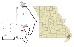
Location within New Madrid County and Missouri
|
|
| Country | United States |
| State | Missouri |
| County | New Madrid |
| Area | |
| • Total | 1.11 sq mi (2.86 km2) |
| • Land | 1.10 sq mi (2.86 km2) |
| • Water | 0.00 sq mi (0.00 km2) |
| Elevation | 292 ft (89 m) |
| Population
(2020)
|
|
| • Total | 397 |
| • Density | 359.28/sq mi (138.76/km2) |
| Time zone | UTC-6 (Central (CST)) |
| • Summer (DST) | UTC-5 (CDT) |
| ZIP code |
63866
|
| Area code(s) | 573 |
| FIPS code | 29-46406 |
| GNIS feature ID | 2395026 |
Marston is a small city in New Madrid County, Missouri, in the United States. In 2020, about 397 people lived there. It is located near the Mississippi River.
Contents
History of Marston
The town of Marston got its name from the maiden name of an early settler's mother. A post office opened in Marston in 1898. The community officially became a city in 1905.
Geography and Location
Marston is located in southeastern Missouri. It sits just west of the mighty Mississippi River. The city is also found along U.S. Route 61.
Interstate 55 also goes through the eastern part of Marston. Both of these major roads, I-55 and US 61, connect Marston to other nearby towns. For example, they link Marston to New Madrid to the northeast and Portageville to the southwest.
The United States Census Bureau says that Marston covers a total area of about 1.11 square miles (2.86 square kilometers). All of this area is land, with no water.
Population Changes
The number of people living in Marston has changed over the years. Here's a quick look at how the population has grown and shrunk:
| Historical population | |||
|---|---|---|---|
| Census | Pop. | %± | |
| 1910 | 258 | — | |
| 1920 | 438 | 69.8% | |
| 1930 | 350 | −20.1% | |
| 1940 | 468 | 33.7% | |
| 1950 | 610 | 30.3% | |
| 1960 | 631 | 3.4% | |
| 1970 | 666 | 5.5% | |
| 1980 | 742 | 11.4% | |
| 1990 | 691 | −6.9% | |
| 2000 | 610 | −11.7% | |
| 2010 | 503 | −17.5% | |
| 2020 | 397 | −21.1% | |
| U.S. Decennial Census | |||
People in Marston (2010)
In 2010, there were 503 people living in Marston. These people lived in 226 different homes. About 137 of these homes were families.
The city had about 453 people per square mile. Most people in Marston were White (80.12%). About 17.69% were Black or African American. A small number of people were from other racial backgrounds.
In 28.8% of homes, there were children under 18 years old. The average age of people in Marston was 42.1 years. About 22.3% of residents were under 18 years old. Also, 14.7% of residents were 65 years or older.
See also
 In Spanish: Marston (Misuri) para niños
 | Jessica Watkins |
 | Robert Henry Lawrence Jr. |
 | Mae Jemison |
 | Sian Proctor |
 | Guion Bluford |

