Dunklin County, Missouri facts for kids
Quick facts for kids
Dunklin County
|
|
|---|---|

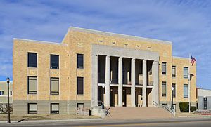
Dunklin County Courthouse in Kennett
|
|

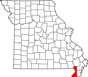
Location within the U.S. state of Missouri
|
|
 Missouri's location within the U.S. |
|
| Country | |
| State | |
| Founded | February 14, 1845 |
| Named for | Daniel Dunklin |
| Seat | Kennett |
| Largest city | Kennett |
| Area | |
| • Total | 547 sq mi (1,420 km2) |
| • Land | 541 sq mi (1,400 km2) |
| • Water | 6.1 sq mi (16 km2) 1.1% |
| Population
(2020)
|
|
| • Total | 28,283 |
| • Density | 51.71/sq mi (19.964/km2) |
| Time zone | UTC−6 (Central) |
| • Summer (DST) | UTC−5 (CDT) |
| Congressional district | 8th |
Dunklin County is located in the Bootheel area of Missouri, a state in the United States. As of the 2020 census, about 28,283 people lived here. The largest city and the main town for the county government is Kennett.
Dunklin County is part of the Kennett, MO Micropolitan Statistical Area. This means it's a small urban area with strong ties to Kennett.
Contents
History
Before Dunklin County was officially formed, the land was home to the Delaware Tribe of Indians. They had lived in this area since the early 1800s. The county was officially created on February 14, 1845. It was named after Daniel Dunklin, who was a Governor of Missouri. He had passed away the year before the county was organized.
The very first courthouse in Dunklin County was built in Kennett in 1847. It was a two-story building made of logs. Sadly, this courthouse burned down in the mid-1860s, around the time of the American Civil War. Most of the county's important records were lost in that fire.
A second courthouse was built in 1872, but it also burned down soon after it was finished. For the next 20 years, from 1872 to 1892, the county government used a rented building. In 1892, a third courthouse was built. It was a two-story brick building. The current courthouse, which you can see today, replaced it in 1929. It was built with help from the Works Progress Administration, a government program that created jobs during the Great Depression.
Geography
Dunklin County covers a total area of about 547 square miles (1,417 square kilometers). Most of this area, 541 square miles (1,401 square kilometers), is land. The remaining 6.1 square miles (16 square kilometers) is water.
The lowest point in the entire state of Missouri is found in Dunklin County. It's located on the St. Francis River in Buffalo Township, right where the river flows out of Missouri and into Arkansas.
Adjacent counties
Dunklin County shares borders with several other counties:
- Stoddard County (north)
- New Madrid County (northeast)
- Pemiscot County (east)
- Mississippi County, Arkansas (southeast)
- Craighead County, Arkansas (south)
- Greene County, Arkansas (southwest)
- Clay County, Arkansas (west)
- Butler County (northwest)
Demographics
| Historical population | |||
|---|---|---|---|
| Census | Pop. | %± | |
| 1850 | 1,229 | — | |
| 1860 | 5,026 | 309.0% | |
| 1870 | 5,982 | 19.0% | |
| 1880 | 9,604 | 60.5% | |
| 1890 | 15,085 | 57.1% | |
| 1900 | 21,706 | 43.9% | |
| 1910 | 30,328 | 39.7% | |
| 1920 | 32,773 | 8.1% | |
| 1930 | 35,799 | 9.2% | |
| 1940 | 44,957 | 25.6% | |
| 1950 | 45,329 | 0.8% | |
| 1960 | 39,139 | −13.7% | |
| 1970 | 33,742 | −13.8% | |
| 1980 | 36,324 | 7.7% | |
| 1990 | 33,112 | −8.8% | |
| 2000 | 33,155 | 0.1% | |
| 2010 | 31,953 | −3.6% | |
| 2020 | 28,283 | −11.5% | |
| U.S. Decennial Census 1790-1960 1900-1990 1990-2000 2010-2015 2020 |
|||
In 2000, there were 33,155 people living in Dunklin County. About 26% of the population was under 18 years old. The average age of people in the county was 38 years. For every 100 females, there were about 90 males.
Religion
Dunklin County is part of an area known as the Bible Belt. This means that many people in the county follow evangelical Protestantism. The most common religious groups in Dunklin County are Southern Baptists, Methodists, and Churches of Christ.
2020 census
The table below shows the different racial groups living in Dunklin County according to the 2020 census:
| Race | Num. | Perc. |
|---|---|---|
| White (NH) | 21,629 | 76.47% |
| Black or African American (NH) | 3,176 | 11.23% |
| Native American (NH) | 70 | 0.25% |
| Asian (NH) | 78 | 0.28% |
| Pacific Islander (NH) | 4 | 0.01% |
| Other/Mixed (NH) | 1,284 | 4.54% |
| Hispanic or Latino | 2,042 | 7.22% |
Education
In Dunklin County, about 63.7% of adults aged 25 and older have a high school diploma or higher. About 9.1% have a bachelor's degree or even higher education.
Public schools
Dunklin County has several public school districts:
- Campbell R-II School District
- Campbell Elementary School (Preschool-6th grade)
- Campbell High School (7th-12th grade)
- Clarkton C-4 School District
- Clarkton Elementary School (Preschool-6th grade)
- Clarkton High School (7th-12th grade)
- Holcomb R-III School District
- Holcomb Elementary School (Preschool-6th grade)
- Holcomb High School (7th-12th grade)
- Kennett School District 39
- Early Childhood Center (Preschool)
- H. Byron Masterson Elementary School (Kindergarten-2nd grade)
- South Elementary School (3rd-5th grade)
- Kennett Middle School (6th-8th grade)
- Kennett High School (9th-12th grade)
- Malden R-I School District
- Malden Elementary School (Preschool-6th grade)
- Malden High School (7th-12th grade)
- Senath-Hornersville C-8 School District
- Senath Elementary School (Preschool-4th grade)
- Hornersville Middle School (5th-8th grade)
- Senath-Hornersville High School (9th-12th grade)
- Cardwell C-9 School District
- Southland Elementary School (Kindergarten-6th grade)
- Southland High School (7th-12th grade)
Private schools
- Kennett Christian Academy in Kennett (Kindergarten-12th grade) - This school is connected to the Assemblies of God/Pentecostal churches.
- St. Teresa School in Campbell (Preschool-8th grade) - This is a Roman Catholic school.
Alternative and vocational schools
- Bootheel State School in Clarkton (Kindergarten-12th grade) - This school helps students with special needs.
- Diagnostic Center in Kennett (Preschool-12th grade) - This center focuses on special education.
- Kennett Area Vocational School in Kennett (9th-12th grade) - This school offers training for different jobs and trades.
Public libraries
- Dunklin County Library
- Arbyrd Community Library
Transportation
Major highways
Several important roads pass through Dunklin County:
Airports
Kennett Memorial Airport is a public airport in Dunklin County. It is located near Kennett, and the city of Kennett owns it.
Media
Radio
You can listen to these radio stations in Dunklin County: FM
- FM 89.9 KAUF Kennett
- FM 92.9 KLSC Malden
- LPFM 102.5 KCJS Kennett
- FM 104.3 KXOQ Kennett
- FM 105.5 KBOA-FM Piggott, AR-Kennett
- FM 106.5 KTMO New Madrid-Kennett
- FM 107.5 KFEB Campbell
AM
- AM1470 KMAL Malden
- AM1540 KBOA Kennett
Local newspapers in Dunklin County include:
- Campbell Courier, from Campbell, Missouri
- Delta Dunklin Democrat, from Kennett, Missouri
Television
There are no television stations located directly in Dunklin County. The county is part of the Paducah, KY, Cape Girardeau, MO, & Harrisburg, Illinois Television Market. Stations from this market include:
- ABC- WSIL 3
- NBC- WPSD 6
- CBS- KFVS 12
- FOX- KBSI 23
- PBS- WSIU 8 & WKPD 29
- MYTV- WDKA 49
Some people in the southern part of the county also watch stations from the Memphis, TN and Jonesboro, AR Television Markets.
Communities
Dunklin County has many towns and communities:
- Arbyrd
- Arkmo
- Baird
- Brian
- Buck Donic
- Bucoda
- Campbell
- Cardwell
- Caruth
- Clarkton
- Cockrum
- Cotton Plant
- Dillman
- Europa
- Frisbee
- Gibson
- Glennonville
- Gobler
- Hargrove
- Holcomb
- Hollywood
- Hornersville
- Ipley
- Kennett (county seat)
- Mackeys
- Malden
- Marlow
- McGuire
- Nesbit
- Octa
- Providence
- Rives
- Senath
- Sumach
- Townley
- Valley Ridge
- Vincit
- White Oak
- Wilhelmina
- Wrightsville
Notable people
Many interesting people have come from Dunklin County:
- Sheryl Crow, a famous singer and songwriter who has won many Grammy awards. She was born and grew up in Kennett.
- David Nail, a country music singer, was born and raised in Kennett.
- Trent Tomlinson, another country music singer and songwriter, was also born and raised in Kennett.
- Onie Wheeler, a musician known for country and bluegrass music.
See also
 In Spanish: Condado de Dunklin para niños
 | Jewel Prestage |
 | Ella Baker |
 | Fannie Lou Hamer |

