Clay County, Arkansas facts for kids
Quick facts for kids
Clay County
|
|
|---|---|

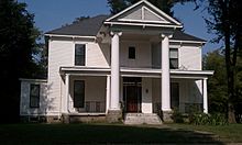
Historic Sheeks House in Corning, Arkansas.
|
|

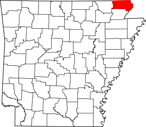
Location within the U.S. state of Arkansas
|
|
 Arkansas's location within the U.S. |
|
| Country | |
| State | |
| Founded | 24 March, 1873 |
| Seat | Corning (western district); Piggott (eastern district) |
| Largest city | Piggott |
| Area | |
| • Total | 641 sq mi (1,660 km2) |
| • Land | 639 sq mi (1,660 km2) |
| • Water | 2.0 sq mi (5 km2) 0.3%% |
| Population
(2020)
|
|
| • Total | 14,552 |
| • Estimate
(2023)
|
14,201 |
| • Density | 22.702/sq mi (8.765/km2) |
| Time zone | UTC−6 (Central) |
| • Summer (DST) | UTC−5 (CDT) |
| Congressional district | 1st |
Clay County is a place in the U.S. state of Arkansas. It's like a smaller region within the state. In 2020, about 14,552 people lived here.
Clay County is special because it has two main towns that act as its "county seats": Corning and Piggott. A county seat is like the main office for the county government. Also, Clay County has rules about where and how alcoholic drinks can be sold.
Contents
History of Clay County
Clay County became Arkansas's 67th county on March 24, 1873. At first, it was called Clayton County. It was named after John M. Clayton, who was a senator in Arkansas. Some people think it might have been named after his brother, Powell Clayton, who was a U.S. Senator.
A couple of years later, in 1875, the county's name was made shorter to "Clay." Some say this was to honor a famous statesman named Henry Clay. Others believe it was still named after John M. Clayton. The name change might have happened because people didn't fully trust Powell Clayton. He had made some strict rules when he was the Governor of Arkansas.
How the County Seats Changed
The first county seat was Corning, set up in 1873. This happened when the St. Louis, Iron Mountain and Southern Railway came through. Corning was the first town in the county to be officially recognized.
In 1877, the county seat moved to Boydsville. This was because people living east of the Black and Cache Rivers found it hard to get to Corning when there were floods. But then, people living west of the rivers had trouble. So, in 1881, Corning became the seat for the Western District again. Boydsville stayed the seat for the Eastern District.
Later, in 1882, another railroad, the St. Louis, Arkansas and Texas Railroad, arrived. This helped other towns like Greenway, Rector, and Piggott grow. In 1887, the Eastern District's seat moved to Piggott. This is why Clay County still has two county seats today! Important county meetings happen in both Piggott and Corning.
Geography
Clay County covers about 641 square miles. Most of this area, about 639 square miles, is land. Only a small part, about 2 square miles, is water.
Major Highways
These are the main roads that go through Clay County:
 Future Interstate 57
 U.S. Highway 49
 U.S. Highway 62
 U.S. Highway 67
 Highway 90
 Highway 119
 Highway 139
Neighboring Counties
Clay County shares its borders with these other counties:
- Butler County, Missouri (to the north)
- Dunklin County, Missouri (to the east)
- Greene County (to the south)
- Randolph County (to the west)
- Ripley County, Missouri (to the northwest)
People in Clay County (Demographics)
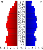
| Historical population | |||
|---|---|---|---|
| Census | Pop. | %± | |
| 1880 | 7,213 | — | |
| 1890 | 12,200 | 69.1% | |
| 1900 | 15,886 | 30.2% | |
| 1910 | 23,690 | 49.1% | |
| 1920 | 27,276 | 15.1% | |
| 1930 | 27,278 | 0.0% | |
| 1940 | 28,386 | 4.1% | |
| 1950 | 26,674 | −6.0% | |
| 1960 | 21,258 | −20.3% | |
| 1970 | 18,771 | −11.7% | |
| 1980 | 20,616 | 9.8% | |
| 1990 | 18,107 | −12.2% | |
| 2000 | 17,609 | −2.8% | |
| 2010 | 16,083 | −8.7% | |
| 2020 | 14,552 | −9.5% | |
| 2023 (est.) | 14,201 | −11.7% | |
| U.S. Decennial Census 1790–1960 1900–1990 1990–2000 2010 |
|||
2020 Census Information
The 2020 United States census counted how many people lived in Clay County and learned about their backgrounds.
| Race | Number | Percentage |
|---|---|---|
| White (non-Hispanic) | 13,574 | 93.28% |
| Black or African American (non-Hispanic) | 40 | 0.27% |
| Native American | 44 | 0.3% |
| Asian | 14 | 0.1% |
| Pacific Islander | 5 | 0.03% |
| Other/Mixed | 548 | 3.77% |
| Hispanic or Latino | 327 | 2.25% |
In 2020, there were 14,552 people living in the county. These people made up 6,444 households and 4,140 families.
Economy
Farming is very important to Clay County's economy. Farmers here grow many different kinds of crops. Rice is the most common crop. They also grow a lot of cotton, soybeans, corn, hay, and milo. There are also a few factories in the cities of Piggott, Corning, and Rector.
Education
Students in Clay County go to public schools provided by these districts:
- Corning School District
- Greene County Tech School District
- Piggott School District
- Rector School District
Communities
Cities
- Corning (county seat)
- Greenway
- Knobel
- Peach Orchard
- Piggott (county seat)
- Pollard
- Rector
- St. Francis
Towns
Unincorporated Community
- Scatterville
- Moark
- Palatka
Townships
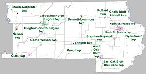
Townships in Arkansas are the divisions of a county. Each township includes unincorporated areas; some may have incorporated cities or towns within part of their boundaries. Arkansas townships have limited purposes in modern times. However, the United States Census does list Arkansas population based on townships (sometimes referred to as "county subdivisions" or "minor civil divisions"). Townships are also of value for historical purposes in terms of genealogical research. Each town or city is within one or more townships in an Arkansas county based on census maps and publications. The townships of Clay County are listed below; listed in parentheses are the cities, towns, and/or census-designated places that are fully or partially inside the township.
- Bennett-Lemmons (McDougal)
- Bradshaw-Haywood (Greenway)
- Brown-Carpenter (Success)
- Cache-Wilson (Knobel)
- Chalk Bluff-Liddell (part of St. Francis)
- Clark (Peach Orchard)
- Cleveland-North Kilgore (part of Corning)
- East Oak Bluff-Blue Cane (part of Rector)
- Gleghorn-South Kilgore (part of Corning)
- Johnson
- Knob
- Nelson (Datto)
- North St. Francis (part of Piggott)
- Payne-Swain (Nimmons)
- Pollard (Pollard)
- South St. Francis (part of Piggott)
- West Oak Bluff (part of Rector)
See also
 In Spanish: Condado de Clay (Arkansas) para niños
 | Delilah Pierce |
 | Gordon Parks |
 | Augusta Savage |
 | Charles Ethan Porter |


