St. Francis, Arkansas facts for kids
Quick facts for kids
St. Francis, Arkansas
|
|
|---|---|

St. Francis
|
|

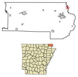
Location of St. Francis in Clay County, Arkansas.
|
|
| Country | United States |
| State | Arkansas |
| County | Clay |
| Area | |
| • Total | 0.37 sq mi (0.95 km2) |
| • Land | 0.35 sq mi (0.92 km2) |
| • Water | 0.01 sq mi (0.03 km2) |
| Elevation | 299 ft (91 m) |
| Population
(2020)
|
|
| • Total | 218 |
| • Density | 614.08/sq mi (237.32/km2) |
| Time zone | UTC-6 (Central (CST)) |
| • Summer (DST) | UTC-5 (CDT) |
| ZIP code |
72464
|
| FIPS code | 05-61970 |
| GNIS feature ID | 2405393 |
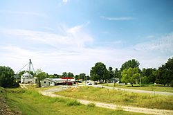
St. Francis is a small city located in the northeastern part of Clay County, Arkansas. It sits right next to the St. Francis River. In 2020, about 218 people lived there.
Contents
A Look Back in Time
The area around St. Francis was first settled in the 1840s. Early residents formed a community called Chalk Bluff. This was just a little bit northwest of where the city is today.
An important event happened here during the Civil War. In May 1863, the Battle of Chalk Bluff was fought nearby.
Later, in 1882, a railroad called the St. Louis Southwestern Railway (also known as the "Cotton Belt") was built through the area. Because of the railroad, the Chalk Bluff community slowly moved southeast. It settled in a new spot right along the train tracks. This new community was named "St. Francis." It got its name from the nearby St. Francis River, which was named after Francis of Assisi.
Where is St. Francis?
St. Francis is found near the very top right corner of Clay County. The St. Francis River runs along its eastern side. This river also marks the border between Arkansas and Missouri.
U.S. Route 62, a main road, goes through the city. If you drive southwest on this road for about 7 miles (11 km), you will reach Piggott. If you go northeast for about 4 miles (6 km), you will arrive in Campbell, Missouri.
The United States Census Bureau says that St. Francis covers a total area of about 0.37 square miles (0.95 square kilometers). All of this area is land.
Who Lives in St. Francis?
| Historical population | |||
|---|---|---|---|
| Census | Pop. | %± | |
| 1890 | 356 | — | |
| 1900 | 420 | 18.0% | |
| 1910 | 459 | 9.3% | |
| 1920 | 501 | 9.2% | |
| 1930 | 294 | −41.3% | |
| 1940 | 266 | −9.5% | |
| 1950 | 292 | 9.8% | |
| 1960 | 224 | −23.3% | |
| 1970 | 297 | 32.6% | |
| 1980 | 266 | −10.4% | |
| 1990 | 201 | −24.4% | |
| 2000 | 250 | 24.4% | |
| 2010 | 250 | 0.0% | |
| 2020 | 218 | −12.8% | |
| U.S. Decennial Census | |||
In 2000, there were 250 people living in St. Francis. These people lived in 103 households, and 70 of these were families. The city had about 837 people per square mile (323 people per square kilometer).
Most of the people living in St. Francis were White (96.80%). A small number were Native American (1.20%), and 2.00% were from two or more racial backgrounds. About 0.40% of the population identified as Hispanic or Latino.
About 34% of the households had children under 18 living with them. More than half (55.3%) were married couples. About 10.7% were households led by a woman without a husband present. Nearly a third (31.1%) were not families.
The average household had about 2.43 people. The average family had about 2.94 people.
The population was spread out by age. About 25.6% were under 18 years old. About 12.0% were between 18 and 24. The largest group, 28.0%, was between 25 and 44. About 21.6% were between 45 and 64, and 12.8% were 65 or older. The average age in the city was 33 years.
Learning in St. Francis
Students in St. Francis attend schools that are part of the Piggott School District.
See also
 In Spanish: Saint Francis (Arkansas) para niños
 | Georgia Louise Harris Brown |
 | Julian Abele |
 | Norma Merrick Sklarek |
 | William Sidney Pittman |

