Peach Orchard, Arkansas facts for kids
Quick facts for kids
Peach Orchard, Arkansas
|
|
|---|---|

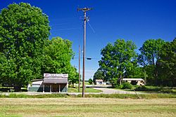
North Main Street
|
|

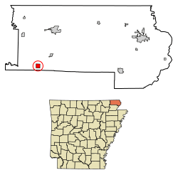
Location of Peach Orchard in Clay County, Arkansas.
|
|
| Country | United States |
| State | Arkansas |
| County | Clay |
| Area | |
| • Total | 1.03 sq mi (2.67 km2) |
| • Land | 1.03 sq mi (2.67 km2) |
| • Water | 0.00 sq mi (0.00 km2) |
| Elevation | 285 ft (87 m) |
| Population
(2020)
|
|
| • Total | 105 |
| • Density | 101.94/sq mi (39.36/km2) |
| Time zone | UTC-6 (Central (CST)) |
| • Summer (DST) | UTC-5 (CDT) |
| ZIP code |
72453
|
| Area code(s) | 870 |
| FIPS code | 05-54140 |
| GNIS feature ID | 2404493 |
Peach Orchard is a small city located in Clay County, Arkansas, United States. In 2010, 135 people lived there. By 2020, the population was 105.
Contents
History of Peach Orchard
Peach Orchard started as a large property called "Petit Baril." A French explorer named Pierre Le Mieux set it up in the early 1800s. By 1816, when Le Mieux sold the land, local English speakers were already calling it "Peach Orchard."
In the mid-1800s, a trading post was active in Peach Orchard. During the American Civil War, this trading post was often attacked by small, unofficial groups of soldiers.
Growth with the Railroad
The area grew a lot when the St. Louis, Iron Mountain and Southern Railway was built in the 1870s. This brought more people and businesses, especially those related to the railroad and cutting down trees for wood.
A post office opened in Peach Orchard in 1873. A train station was also built. Peach Orchard officially became a city in 1910.
Geography of Peach Orchard
Peach Orchard is located southwest of Corning. It sits along Arkansas Highway 90, between the towns of Knobel and Delaplaine.
The United States Census Bureau says that Peach Orchard covers about 1.0 square mile (2.6 square kilometers) of land. There is no water area within the city limits.
Population Changes
| Historical population | |||
|---|---|---|---|
| Census | Pop. | %± | |
| 1920 | 484 | — | |
| 1930 | 361 | −25.4% | |
| 1940 | 374 | 3.6% | |
| 1950 | 327 | −12.6% | |
| 1960 | 348 | 6.4% | |
| 1970 | 256 | −26.4% | |
| 1980 | 243 | −5.1% | |
| 1990 | 197 | −18.9% | |
| 2000 | 195 | −1.0% | |
| 2010 | 135 | −30.8% | |
| 2020 | 105 | −22.2% | |
| U.S. Decennial Census | |||
In 2000, there were 195 people living in Peach Orchard. About 25% of the people were under 18 years old. The average age was 40 years. Most of the people living there were White.
Economy
In 2011, Peach Orchard did not have any restaurants. It also did not have any grocery stores, though it used to have two.
Education
Peach Orchard is part of the Greene County Tech School District. This district is based in Paragould. Even though Peach Orchard is surrounded by the Corning School District, its students go to schools in the Greene County Tech district. The high school for students from Peach Orchard is Greene County Tech High School.
Past Schools
Peach Orchard used to have its own schools. Later, these schools joined with the Delaplaine School District. This district operated Delaplaine High School.
In 2004, the Delaplaine school district became part of the Greene County Tech school district. The schools in Delaplaine closed in 2006. After that, students from Peach Orchard started going to schools in the Greene County area.
See also
 In Spanish: Peach Orchard (Arkansas) para niños
 | Ernest Everett Just |
 | Mary Jackson |
 | Emmett Chappelle |
 | Marie Maynard Daly |

