Corning, Arkansas facts for kids
Quick facts for kids
Corning, Arkansas
|
|
|---|---|

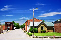
Vine Street
|
|

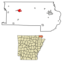
Location of Corning in Clay County, Arkansas.
|
|
| Country | United States |
| State | Arkansas |
| County | Clay |
| Government | |
| • Type | Mayor-council government |
| Area | |
| • Total | 3.70 sq mi (9.58 km2) |
| • Land | 3.67 sq mi (9.51 km2) |
| • Water | 0.03 sq mi (0.08 km2) |
| Elevation | 292 ft (89 m) |
| Population
(2020)
|
|
| • Total | 3,227 |
| • Density | 879.05/sq mi (339.41/km2) |
| Time zone | UTC-6 (Central (CST)) |
| • Summer (DST) | UTC-5 (CDT) |
| ZIP code |
72422
|
| Area code(s) | 870 |
| FIPS code | 05-15460 |
| GNIS feature ID | 2404134 |
Corning is a city located in Clay County, Arkansas, in the United States. In 2020, about 3,227 people lived there. It is one of the two main cities, or county seats, of Clay County. The other county seat is Piggott.
Contents
History of Corning
Corning started as a settlement called Hecht City. It was named after two brothers, Levi and Solomon Hecht. They ran a lumber mill near the Black River. In 1871, Hecht City moved to where Corning is today. This happened because the Cairo and Fulton Railroad planned to build tracks through the area.
The railroad was finished by 1872. On February 5, 1873, the town's name changed. It became Corning, honoring H. D. Corning, an engineer for the railroad.
Corning grew a lot in the early 1900s. In the 1960s and 1970s, many factories and industries came to the city.
A big explosion happened in Corning on March 9, 1966. It was caused by a railcar carrying explosives. Even though it was a large blast, only one person had a minor injury. News about the explosion spread widely in the area.
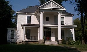
Two buildings in Corning are special because of their history. They are the Sheeks House and the Oliver House. Both are listed on the National Register of Historic Places. This means they are important historical sites.
Geography and Location
Corning is in the western part of Clay County. It is about 2 miles (3.2 km) west of the Black River. Major roads like U.S. Route 62 and U.S. Route 67 pass through the city.
U.S. Route 62 goes east to Piggott (about 25 miles or 40 km away). It also goes southwest to Pocahontas (about 26 miles or 42 km away). U.S. Route 67 goes north from Corning to Poplar Bluff, Missouri. It also joins US 62 to go southwest towards Pocahontas.
The United States Census Bureau says Corning covers about 3.70 square miles (9.58 km2). Most of this area is land, with a small part being water.
The land in Corning is mostly flat. It used to be marshland, which is a type of wetland. Farmers and builders in the area often find "gumbo soil." This soil has a lot of clay and is common in this region.
Climate and Weather
Corning has a climate with hot, humid summers. Winters are usually mild to cold. This type of weather is called a humid subtropical climate. On climate maps, it's shown as "Cfa."
The hottest temperature ever recorded in Corning was 113°F (45°C). This happened on August 8–9, 1934, and again on June 20, 1936. The coldest temperature recorded was -25°F (-32°C) on February 12, 1899.
Corning also holds a record for snowfall in Arkansas. On January 22, 1918, the city received 25 inches (64 cm) of snow in just one day. This was the most snow recorded in Arkansas in 24 hours.
| Climate data for Corning, Arkansas, 1991–2020 normals, extremes 1893–present | |||||||||||||
|---|---|---|---|---|---|---|---|---|---|---|---|---|---|
| Month | Jan | Feb | Mar | Apr | May | Jun | Jul | Aug | Sep | Oct | Nov | Dec | Year |
| Record high °F (°C) | 79 (26) |
84 (29) |
94 (34) |
95 (35) |
101 (38) |
113 (45) |
111 (44) |
113 (45) |
107 (42) |
98 (37) |
87 (31) |
78 (26) |
113 (45) |
| Mean maximum °F (°C) | 65.8 (18.8) |
70.7 (21.5) |
77.9 (25.5) |
84.5 (29.2) |
90.1 (32.3) |
95.3 (35.2) |
97.4 (36.3) |
97.2 (36.2) |
93.6 (34.2) |
86.9 (30.5) |
76.5 (24.7) |
67.1 (19.5) |
99.2 (37.3) |
| Mean daily maximum °F (°C) | 44.7 (7.1) |
50.1 (10.1) |
59.7 (15.4) |
70.6 (21.4) |
79.1 (26.2) |
87.1 (30.6) |
89.7 (32.1) |
88.7 (31.5) |
82.7 (28.2) |
72.2 (22.3) |
58.4 (14.7) |
47.8 (8.8) |
69.2 (20.7) |
| Daily mean °F (°C) | 36.4 (2.4) |
40.9 (4.9) |
49.8 (9.9) |
60.0 (15.6) |
69.4 (20.8) |
77.5 (25.3) |
80.4 (26.9) |
78.7 (25.9) |
71.6 (22.0) |
60.6 (15.9) |
48.8 (9.3) |
39.7 (4.3) |
59.5 (15.3) |
| Mean daily minimum °F (°C) | 28.2 (−2.1) |
31.7 (−0.2) |
40.0 (4.4) |
49.5 (9.7) |
59.6 (15.3) |
67.9 (19.9) |
71.1 (21.7) |
68.7 (20.4) |
60.4 (15.8) |
49.0 (9.4) |
39.2 (4.0) |
31.5 (−0.3) |
49.7 (9.8) |
| Mean minimum °F (°C) | 11.8 (−11.2) |
14.9 (−9.5) |
22.6 (−5.2) |
34.3 (1.3) |
44.2 (6.8) |
56.8 (13.8) |
62.4 (16.9) |
58.6 (14.8) |
45.7 (7.6) |
33.5 (0.8) |
24.5 (−4.2) |
16.2 (−8.8) |
8.4 (−13.1) |
| Record low °F (°C) | −21 (−29) |
−25 (−32) |
5 (−15) |
22 (−6) |
35 (2) |
44 (7) |
40 (4) |
43 (6) |
28 (−2) |
21 (−6) |
9 (−13) |
−9 (−23) |
−25 (−32) |
| Average precipitation inches (mm) | 3.32 (84) |
3.74 (95) |
4.74 (120) |
5.48 (139) |
5.09 (129) |
3.87 (98) |
4.01 (102) |
3.29 (84) |
3.34 (85) |
3.72 (94) |
4.56 (116) |
4.33 (110) |
49.49 (1,256) |
| Average snowfall inches (cm) | 0.9 (2.3) |
2.2 (5.6) |
0.5 (1.3) |
0.0 (0.0) |
0.0 (0.0) |
0.0 (0.0) |
0.0 (0.0) |
0.0 (0.0) |
0.0 (0.0) |
0.0 (0.0) |
0.2 (0.51) |
0.8 (2.0) |
4.6 (11.71) |
| Average precipitation days (≥ 0.01 in) | 8.0 | 8.6 | 9.9 | 9.6 | 10.6 | 7.8 | 8.1 | 7.5 | 5.8 | 8.2 | 8.3 | 9.1 | 101.5 |
| Average snowy days (≥ 0.1 in) | 0.8 | 0.8 | 0.4 | 0.0 | 0.0 | 0.0 | 0.0 | 0.0 | 0.0 | 0.0 | 0.1 | 0.7 | 2.8 |
| Source 1: NOAA | |||||||||||||
| Source 2: National Weather Service | |||||||||||||
Population and People
| Historical population | |||
|---|---|---|---|
| Census | Pop. | %± | |
| 1880 | 393 | — | |
| 1890 | 584 | 48.6% | |
| 1900 | 1,041 | 78.3% | |
| 1910 | 1,439 | 38.2% | |
| 1920 | 1,564 | 8.7% | |
| 1930 | 1,550 | −0.9% | |
| 1940 | 1,619 | 4.5% | |
| 1950 | 2,045 | 26.3% | |
| 1960 | 2,192 | 7.2% | |
| 1970 | 2,705 | 23.4% | |
| 1980 | 3,650 | 34.9% | |
| 1990 | 3,323 | −9.0% | |
| 2000 | 3,679 | 10.7% | |
| 2010 | 3,377 | −8.2% | |
| 2020 | 3,227 | −4.4% | |
| U.S. Decennial Census 2014 Estimate |
|||
Corning's Population in 2020
| Race | Number | Percentage |
|---|---|---|
| White (non-Hispanic) | 2,999 | 92.93% |
| Black or African American (non-Hispanic) | 4 | 0.12% |
| Native American | 10 | 0.31% |
| Asian | 5 | 0.15% |
| Other/Mixed | 132 | 4.09% |
| Hispanic or Latino | 77 | 2.39% |
In 2020, the 2020 United States census counted 3,227 people living in Corning. There were 1,421 households and 934 families in the city.
Education in Corning
Students in Corning attend public schools run by the Corning School District. Corning High School is part of the Arkansas Activities Association.
The high school offers many subjects. These include Art, Band, Spanish, Computer Tech, and Family and Consumer Sciences. They also have all the basic classes found in public schools. The school district's mascot is the bobcat.
Corning is proud of its high school sports teams. Boys can play football, track, basketball, golf, baseball, and trap shooting. Girls can join basketball, softball, track, and golf teams.
The high school football team has had strong seasons. For example, in 2007, the team went undefeated and reached the second round of the state playoffs. The varsity girls' basketball team also did well. They played in the state Division 3A playoffs in 2009, 2010, and 2011.
Farming and Industry
The main type of business in Corning is related to farming. This includes selling and repairing farm equipment. It also involves processing and selling seeds, and making fertilizers and chemicals.
In the late 1800s and early 1900s, cutting down trees (forestry) was a big industry. But over time, farming became more important. Today, farmers in Corning grow crops like rice, soybeans, wheat, corn, and other grains.
Famous People from Corning
- Jack Ladyman: He is a Republican member of the Arkansas House of Representatives. He represents Jonesboro and used to live in Corning.
- W. Stephen Smith: He is a Professor of Voice at Northwestern University. He is also a voice teacher and author.
See also
 In Spanish: Corning (Arkansas) para niños
 | James Van Der Zee |
 | Alma Thomas |
 | Ellis Wilson |
 | Margaret Taylor-Burroughs |


