Datto, Arkansas facts for kids
Quick facts for kids
Datto, Arkansas
|
|
|---|---|

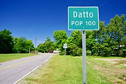
Entrance along U.S. Route 67
|
|

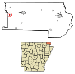
Location of Datto in Clay County, Arkansas.
|
|
| Country | United States |
| State | Arkansas |
| County | Clay |
| Area | |
| • Total | 0.62 sq mi (1.61 km2) |
| Elevation | 289 ft (88 m) |
| Population
(2020)
|
|
| • Total | 65 |
| • Density | 104.67/sq mi (40.42/km2) |
| Time zone | UTC-6 (Central (CST)) |
| • Summer (DST) | UTC-5 (CDT) |
| ZIP code |
72424
|
| Area code(s) | 870 |
| FIPS code | 05-17410 |
| GNIS feature ID | 2406356 |
Datto is a small town located in Clay County, Arkansas, in the United States. According to the 2020 census, 65 people live there.
Contents
History of Datto
How Datto Started
Datto began in 1900 as a stop along the Cotton Belt Railroad. This railroad helped connect towns and move goods.
Choosing the Town's Name
The Day family, including Isaac and his sons Charles and Delmer, gave land for the new town. They wanted to name it "Dayton." However, the U.S. Postal Service did not approve this name. So, the town was named "Datto" instead. Datto officially became a town in 1905.
Geography of Datto
Where Datto is Located
Datto is in the western part of Clay County, Arkansas. It is about 2 miles (3.2 km) east of the Current River.
Roads and Size
Two main roads, U.S. Routes 62 and 67, go through Datto. These roads lead east to Corning, which is about 8 miles (13 km) away. They also lead southwest to Pocahontas, about 17 miles (27 km) from Datto. The town covers a total area of about 1.7 square miles (4.4 km²), and all of it is land.
Population of Datto
Datto's Changing Population
| Historical population | |||
|---|---|---|---|
| Census | Pop. | %± | |
| 1910 | 244 | — | |
| 1920 | 242 | −0.8% | |
| 1930 | 275 | 13.6% | |
| 1940 | 198 | −28.0% | |
| 1950 | 176 | −11.1% | |
| 1960 | 167 | −5.1% | |
| 1970 | 142 | −15.0% | |
| 1980 | 112 | −21.1% | |
| 1990 | 120 | 7.1% | |
| 2000 | 97 | −19.2% | |
| 2010 | 100 | 3.1% | |
| 2020 | 65 | −35.0% | |
| U.S. Decennial Census 2014 Estimate |
|||
The population of Datto has changed over the years. In 2000, there were 97 people living in the town. By 2020, the population was 65 people.
Households and Families
In 2000, there were 44 households in Datto. A household is a group of people living together in one home. Most of these households (59.1%) were married couples. About 27.3% of households had children under 18 living with them.
Age Groups in Datto
The people in Datto in 2000 were spread across different age groups. About 21.6% were under 18 years old. Another 21.6% were 65 years or older. The average age in Datto was 44 years.
Notable People from Datto
- Bill Rice - a country music singer and songwriter.
See also
 In Spanish: Datto (Arkansas) para niños
 | Precious Adams |
 | Lauren Anderson |
 | Janet Collins |

