Cardwell, Missouri facts for kids
Quick facts for kids
Cardwell, Missouri
|
|
|---|---|

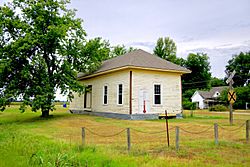
Cotton Belt Depot in Cardwell, MO
|
|

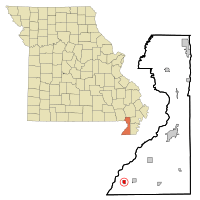
Location of Cardwell, Missouri
|
|
| Country | United States |
| State | Missouri |
| County | Dunklin |
| First settled | 1895 |
| Incorporated | 1904 |
| Named for | Frank Cardwell |
| Area | |
| • Total | 0.63 sq mi (1.63 km2) |
| • Land | 0.63 sq mi (1.63 km2) |
| • Water | 0.00 sq mi (0.00 km2) |
| Elevation | 249 ft (76 m) |
| Population
(2020)
|
|
| • Total | 561 |
| • Density | 890.48/sq mi (343.92/km2) |
| Time zone | UTC-6 (Central (CST)) |
| • Summer (DST) | UTC-5 (CDT) |
| ZIP code |
63829
|
| Area code(s) | 573 |
| FIPS code | 29-11350 |
| GNIS feature ID | 2393741 |
Cardwell is a small city in the southwest part of Dunklin County, Missouri, United States. In 2024, about 526 people lived there. The city was named after Frank Cardwell. He was a banker from Arkansas who helped the town's first settlers. The current mayor of Cardwell is Mike Clark.
Contents
Cardwell's History
Cardwell started to grow in the late 1800s. A railway company began building a new line into the area in 1893. By 1894, land was being sold for a new town.
The very first train arrived in Cardwell in January 1895. Soon after, a post office opened. In 1899, a school district was created for Cardwell. A two-story brick school building was built that July.
In 1902, another railway line was built. It connected Cardwell to Manila, Arkansas. This line was mostly used to transport wood. Cardwell officially became a city in 1904.
Where is Cardwell?
Cardwell is located in the very southwest part of Missouri. It is in an area known as the Bootheel. The state line with Arkansas is very close by, both to the west and south.
Missouri Route 164 goes through Cardwell. This road connects it to nearby towns like Arbyrd and Hornersville. U.S. Route 412 also passes close to the city. The city of Paragould, Arkansas is about ten miles west on Route 412. The St. Francis River flows about two miles west of Cardwell, along the state line.
The city covers a total area of about 0.63 square miles (1.63 square kilometers). All of this area is land.
Cardwell's Weather
Cardwell has a humid subtropical climate. This means it has hot summers. The winters are usually cold.
| Climate data for Cardwell, Missouri | |||||||||||||
|---|---|---|---|---|---|---|---|---|---|---|---|---|---|
| Month | Jan | Feb | Mar | Apr | May | Jun | Jul | Aug | Sep | Oct | Nov | Dec | Year |
| Mean daily maximum °F (°C) | 46 (8) |
51 (11) |
61 (16) |
71 (22) |
80 (27) |
88 (31) |
91 (33) |
90 (32) |
84 (29) |
73 (23) |
60 (16) |
49 (9) |
70 (21) |
| Mean daily minimum °F (°C) | 29 (−2) |
33 (1) |
41 (5) |
50 (10) |
60 (16) |
68 (20) |
71 (22) |
70 (21) |
62 (17) |
50 (10) |
40 (4) |
32 (0) |
51 (10) |
| Average precipitation inches (mm) | 3.3 (84) |
4.1 (100) |
4.7 (120) |
5.2 (130) |
5.2 (130) |
3.5 (89) |
3.8 (97) |
3.4 (86) |
3.2 (81) |
4.3 (110) |
5.0 (130) |
4.9 (120) |
50.6 (1,277) |
| Source: https://www.ncdc.noaa.gov | |||||||||||||
People of Cardwell
The number of people living in Cardwell has changed over the years.
| Historical population | |||
|---|---|---|---|
| Census | Pop. | %± | |
| 1900 | 502 | — | |
| 1910 | 874 | 74.1% | |
| 1920 | 1,043 | 19.3% | |
| 1930 | 861 | −17.4% | |
| 1940 | 913 | 6.0% | |
| 1950 | 952 | 4.3% | |
| 1960 | 816 | −14.3% | |
| 1970 | 859 | 5.3% | |
| 1980 | 831 | −3.3% | |
| 1990 | 792 | −4.7% | |
| 2000 | 789 | −0.4% | |
| 2010 | 713 | −9.6% | |
| 2020 | 561 | −21.3% | |
| source: | |||
2010 Census Information
In 2010, there were 713 people living in Cardwell. These people lived in 317 households. About 180 of these were families.
Most people in Cardwell were White (96.35%). A small number were Black or African American (0.42%) or Native American (0.28%). Some people were from other backgrounds or more than one race. About 3.37% of the population was Hispanic or Latino.
About 30.6% of households had children under 18 living there. The average age of people in the city was about 39.5 years old. About 25% of residents were under 18. About 16.5% were 65 years old or older. The number of males and females was almost equal.
Learning in Cardwell
The Southland C-9 School District runs two schools in Cardwell. These are Southland Elementary School and Southland High School.
Cardwell also has a public library. It is a part of the Dunklin County Library system.
Images for kids
See also
 In Spanish: Cardwell (Misuri) para niños
 | William M. Jackson |
 | Juan E. Gilbert |
 | Neil deGrasse Tyson |


