Arbyrd, Missouri facts for kids
Quick facts for kids
Arbyrd, Missouri
|
|
|---|---|

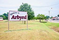
Welcome sign along Route 108
|
|

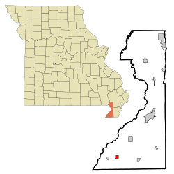
Location of Arbyrd, Missouri
|
|
| Country | United States |
| State | Missouri |
| County | Dunklin |
| Arbyrd | 1919 |
| Area | |
| • Total | 1.00 sq mi (2.60 km2) |
| • Land | 1.00 sq mi (2.60 km2) |
| • Water | 0.00 sq mi (0.00 km2) |
| Elevation | 246 ft (75 m) |
| Population
(2020)
|
|
| • Total | 404 |
| • Density | 402.39/sq mi (155.30/km2) |
| Time zone | UTC-6 (Central (CST)) |
| • Summer (DST) | UTC-5 (CDT) |
| ZIP code |
63821
|
| Area code(s) | 573 |
| FIPS code | 29-01630 |
| GNIS feature ID | 2393971 |
| Website | arbyrdmissouri.com |
Arbyrd is a small town located in the southeastern part of Dunklin County, Missouri, in the United States. In 2020, about 404 people lived there. The town officially became a city in 1919.
History
Arbyrd got its name from a person named A. R. Byrd. He was a businessman who bought a lot of land in the area. The town's name is a shorter version of his name. A post office opened in Arbyrd in 1911, helping the community grow.
Geography
Arbyrd is mainly found along Missouri Route 108. Its borders reach south to where Route 108 meets Missouri Route 164. U.S. Route 412 is just to the west of the town.
Other nearby towns include Cardwell to the west and Hornersville to the east, both along Route 164. Senath is to the northeast along US 412. The state line between Missouri and Arkansas is only three miles south along Route 108. When you cross the border, Route 108 becomes Arkansas Highway 77.
The United States Census Bureau says that Arbyrd covers about 1 square mile (2.6 square kilometers) of land. There is no water area within the city limits.
Climate
Arbyrd experiences a variety of weather throughout the year. Here's a look at the climate data:
| Climate data for Arbyrd, Missouri | |||||||||||||
|---|---|---|---|---|---|---|---|---|---|---|---|---|---|
| Month | Jan | Feb | Mar | Apr | May | Jun | Jul | Aug | Sep | Oct | Nov | Dec | Year |
| Record high °F (°C) | 74 (23) |
80 (27) |
86 (30) |
94 (34) |
98 (37) |
105 (41) |
112 (44) |
109 (43) |
106 (41) |
97 (36) |
87 (31) |
78 (26) |
112 (44) |
| Mean daily maximum °F (°C) | 44 (7) |
50 (10) |
60 (16) |
71 (22) |
80 (27) |
89 (32) |
93 (34) |
91 (33) |
84 (29) |
74 (23) |
60 (16) |
48 (9) |
70 (22) |
| Mean daily minimum °F (°C) | 25 (−4) |
29 (−2) |
38 (3) |
47 (8) |
57 (14) |
65 (18) |
69 (21) |
67 (19) |
59 (15) |
47 (8) |
38 (3) |
29 (−2) |
48 (8) |
| Record low °F (°C) | −12 (−24) |
−4 (−20) |
0 (−18) |
24 (−4) |
34 (1) |
43 (6) |
50 (10) |
46 (8) |
34 (1) |
24 (−4) |
12 (−11) |
−6 (−21) |
22 (−6) |
| Average precipitation inches (mm) | 3.37 (86) |
3.84 (98) |
4.85 (123) |
4.92 (125) |
5.59 (142) |
4.03 (102) |
3.63 (92) |
2.66 (68) |
3.29 (84) |
3.93 (100) |
4.95 (126) |
4.55 (116) |
49.61 (1,260) |
Demographics
The population of Arbyrd has changed over the years. Here's how it has grown and shrunk:
| Historical population | |||
|---|---|---|---|
| Census | Pop. | %± | |
| 1930 | 253 | — | |
| 1940 | 489 | 93.3% | |
| 1950 | 679 | 38.9% | |
| 1960 | 667 | −1.8% | |
| 1970 | 575 | −13.8% | |
| 1980 | 704 | 22.4% | |
| 1990 | 597 | −15.2% | |
| 2000 | 528 | −11.6% | |
| 2010 | 509 | −3.6% | |
| 2020 | 404 | −20.6% | |
| U.S. Decennial Census | |||
2010 census
In 2010, the town had 509 people living in 198 households. About 124 of these were families. The population density was about 509 people per square mile.
Many households (35.4%) had children under 18. About 43.4% of households were married couples living together. Some households had a single parent, either a mother (9.6%) or a father (9.6%). About 37.4% of households were not families.
Almost one-third of all households (31.8%) had only one person living there. About 17.2% of households had someone aged 65 or older living alone. On average, there were 2.57 people per household and 3.24 people per family.
The average age of people in Arbyrd in 2010 was 39.4 years. About 27.7% of residents were under 18, and 18.7% were 65 or older. The town had a fairly even split between males (49.3%) and females (50.7%).
Arts and culture
The Missouri Bootheel area, where Arbyrd is located, is known for being the home of two members of the band The Kentucky Headhunters. Doug and Ricky Phelps grew up in nearby Cardwell and Arbyrd. They went to school in the Southland C-9 school district. After being part of The Kentucky Headhunters, Doug and Ricky started their own band called Brother Phelps.
Education
Arbyrd does not have its own public library. However, it is part of the Dunklin County Library system.
See also
 In Spanish: Arbyrd (Misuri) para niños
 | Toni Morrison |
 | Barack Obama |
 | Martin Luther King Jr. |
 | Ralph Bunche |

