Fulton County, Kentucky facts for kids
Quick facts for kids
Fulton County
|
|
|---|---|

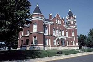
Fulton County Courthouse in Hickman
|
|

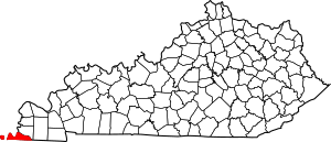
Location within the U.S. state of Kentucky
|
|
 Kentucky's location within the U.S. |
|
| Country | |
| State | |
| Founded | 1845 |
| Named for | Robert Fulton |
| Seat | Hickman |
| Largest city | Hickman |
| Area | |
| • Total | 231 sq mi (600 km2) |
| • Land | 206 sq mi (530 km2) |
| • Water | 25 sq mi (60 km2) 11% |
| Population
(2020)
|
|
| • Total | 6,515 |
| • Estimate
(2023)
|
6,338 |
| • Density | 28.20/sq mi (10.889/km2) |
| Time zone | UTC−6 (Central) |
| • Summer (DST) | UTC−5 (CDT) |
| Congressional district | 1st |
Fulton County is the most western county in the U.S. state of Kentucky. The Mississippi River forms its western edge. In 2020, about 6,515 people lived there.
The county seat, or main town, is Hickman. The biggest city is Fulton. Fulton County was created in 1845 from Hickman County, Kentucky. It was named after Robert Fulton, who invented the steamboat.
During the American Civil War, many white residents in Fulton County supported the Confederate side. This was because they had strong trade and cultural ties with Tennessee. Armies from both sides marched through the county at different times.
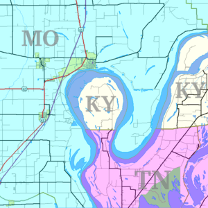
Fulton County has a unique feature. Due to old land surveys, part of the county is separated from the rest of Kentucky. This area is called the Kentucky Bend. It's a piece of land on a peninsula in the Mississippi River. You can only reach it by driving through Tennessee.
Contents
History of Fulton County
Fulton County was officially formed in 1845. It was created from a part of Hickman County. The county was named after Robert Fulton, the famous inventor of the steamboat. Hickman, Kentucky was chosen as the county seat.
The county's economy was based on farming. Early farms relied on the work of enslaved people. Farmers in the area had close ties to planters in Tennessee. They shipped their crops down the Mississippi River. During the Civil War, Kentucky officially stayed neutral. However, many people in Fulton County supported the Confederate states.
After the Civil War, big changes happened. Some African Americans in the county were able to buy their own land.
Geography of Fulton County
Fulton County covers a total area of about 231 square miles. Most of this, about 206 square miles, is land. The remaining 25 square miles, or 11%, is water.
The Kentucky Bend Exclave
About 11 square miles of the county is a special area. It's separated from the rest of Kentucky by a bend in the Mississippi River. This bend is like a loop in the river, called an oxbow. This separated area is known as the Kentucky Bend or New Madrid Bend.
To get to the Kentucky Bend, travelers must drive through Tennessee. There is no bridge directly from Missouri. The lowest point in Kentucky is found here, along the Mississippi River. This is where the river flows between Kentucky, Tennessee, and Missouri. Over time, the river might cut across the narrow neck of the peninsula. If this happens, the Kentucky Bend would become completely separated from Kentucky. It might even connect to Missouri as land fills in behind the river.
Neighboring Counties
Fulton County shares borders with these other counties:
- Mississippi County, Missouri (to the northwest)
- Hickman County (to the northeast)
- Obion County, Tennessee (to the south)
- Lake County, Tennessee (to the southwest)
- New Madrid County, Missouri (to the west)
Protected Areas
Part of the Reelfoot National Wildlife Refuge is located in Fulton County. This refuge helps protect wildlife and their homes.
Main Roads
Several important highways pass through Fulton County:
 US 45
US 45 US 51
US 51 KY 58
KY 58 KY 94
KY 94 KY 116
 KY 123
 KY 125
 KY 166
 KY 239
 KY 307
 KY 781
 KY 924
 KY 1529
Population and People
| Historical population | |||
|---|---|---|---|
| Census | Pop. | %± | |
| 1850 | 4,446 | — | |
| 1860 | 5,317 | 19.6% | |
| 1870 | 6,161 | 15.9% | |
| 1880 | 7,977 | 29.5% | |
| 1890 | 10,005 | 25.4% | |
| 1900 | 11,546 | 15.4% | |
| 1910 | 14,114 | 22.2% | |
| 1920 | 15,197 | 7.7% | |
| 1930 | 14,927 | −1.8% | |
| 1940 | 15,413 | 3.3% | |
| 1950 | 13,668 | −11.3% | |
| 1960 | 11,256 | −17.6% | |
| 1970 | 10,183 | −9.5% | |
| 1980 | 8,971 | −11.9% | |
| 1990 | 8,271 | −7.8% | |
| 2000 | 7,752 | −6.3% | |
| 2010 | 6,813 | −12.1% | |
| 2020 | 6,515 | −4.4% | |
| 2023 (est.) | 6,338 | −7.0% | |
| U.S. Decennial Census 1790-1960 1900-1990 1990-2000 2010-2021 |
|||
2020 Census Information
In 2020, there were 6,515 people living in Fulton County. There were 2,441 households and 1,425 families.
The population was made up of different groups:
| Race | Number | Percent |
|---|---|---|
| White | 4,566 | 70.08% |
| Black or African American | 1,433 | 22.0% |
| Native American | 13 | 0.2% |
| Asian | 17 | 0.26% |
| Pacific Islander | 11 | 0.17% |
| Other/Mixed | 324 | 4.97% |
| Hispanic or Latino | 151 | 2.32% |
Education in Fulton County
Students in Fulton County attend schools in two main districts:
- Fulton County School District
- Fulton Independent Schools
Local Media
Fulton County has a few local radio stations:
- WENK-AM 1240 plays "The Greatest Hits of All Time."
- WWGY 99.3 plays "Today's Best Music with Ace & TJ in the Morning."
Communities in Fulton County
Cities
Census-designated place
Other Small Communities
- Bondurant
- Brownsville
- Crutchfield
- Jordan
- Kentucky Bend
- Mabel
- Miller
- Riceville
- Sassafras Ridge
- State Line
- Tyler
See also
- In Spanish: Condado de Fulton (Kentucky) para niños
 | George Robert Carruthers |
 | Patricia Bath |
 | Jan Ernst Matzeliger |
 | Alexander Miles |


