Hickman County, Kentucky facts for kids
Quick facts for kids
Hickman County
|
|
|---|---|

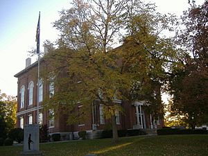
Hickman County Courthouse in Clinton
|
|

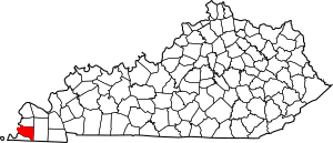
Location within the U.S. state of Kentucky
|
|
 Kentucky's location within the U.S. |
|
| Country | |
| State | |
| Founded | 1821 |
| Named for | Paschal Hickman |
| Seat | Clinton |
| Largest city | Clinton |
| Area | |
| • Total | 253 sq mi (660 km2) |
| • Land | 242 sq mi (630 km2) |
| • Water | 11 sq mi (30 km2) 4.3%% |
| Population
(2020)
|
|
| • Total | 4,521 |
| • Estimate
(2023)
|
4,447 |
| • Density | 17.87/sq mi (6.899/km2) |
| Time zone | UTC−6 (Central) |
| • Summer (DST) | UTC−5 (CDT) |
| Congressional district | 1st |
Hickman County is a county located in the U.S. state of Kentucky. It is in the western part of the state. In 2020, about 4,521 people lived here. This makes it one of the least populated counties in Kentucky. The main town and county seat is Clinton. Hickman County was created in 1821. It is also known as a "dry county," meaning that the sale of alcohol is generally not allowed.
Contents
History of Hickman County
How Hickman County Was Formed
Hickman County was officially created in 1821. It was the 71st county formed in Kentucky. The county was named after Captain Paschal Hickman. He was a brave soldier from Kentucky. Captain Hickman was hurt and captured during the Battle of Frenchtown in 1813. Sadly, he was later killed by Native Americans during the Massacre of the River Raisin.
Early County Seats
The first county seat was Columbus, Kentucky. This town is in the northwest part of the county. It is located right on the Mississippi River. A log building built in 1823 served as the first courthouse. But in 1830, the county seat was moved. It went to Clinton, which was more in the center of the county. Since 1845, when Fulton County, Kentucky was created from part of Hickman County, the county has kept its current shape.
Hickman County During the Civil War
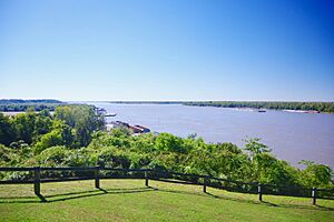
In 1861, at the start of the American Civil War, Hickman County played an important role. The Confederate Army built Fort de Russey at Columbus. This fort was on high ground overlooking the Mississippi River. It was a very important spot for controlling the river. Confederate General Leonidas Polk wanted to stretch a huge chain across the Mississippi. This chain would stop Union boats from going downstream. However, this plan was never finished.
The fort had thousands of soldiers and six cannons. A smaller group of Confederate soldiers was also in Belmont, Missouri, across the river. Union General Ulysses S. Grant led his troops from Cairo, Illinois. He attacked Belmont in November 1861. This was Grant's first battle of the war. But he was defeated by Confederate troops. These troops were sent from Columbus by General Polk to help defend Belmont. Today, the old fort area near Columbus is a park. It is called Columbus-Belmont State Park. It remembers the events of that day.
Geography of Hickman County
Hickman County covers a total area of about 253 square miles (655 square kilometers). Most of this area, about 242 square miles (627 square kilometers), is land. The remaining 11 square miles (28 square kilometers) is water. This means about 4.3% of the county is water.
The land in Hickman County ranges from about 276 feet (84 meters) to 510 feet (155 meters) above sea level. The western edge of the county is formed by the wide Mississippi River. The state of Missouri is on the other side of the river. Some parts of Hickman County are actually on the west side of the Mississippi River. This means they are surrounded by Missouri land.
Neighboring Counties
Hickman County shares its borders with several other counties:
- Carlisle County to the north
- Graves County to the east
- Weakley County, Tennessee to the southeast
- Obion County, Tennessee to the south
- Fulton County to the south
- Mississippi County, Missouri to the west
Population and People
| Historical population | |||
|---|---|---|---|
| Census | Pop. | %± | |
| 1830 | 5,198 | — | |
| 1840 | 8,968 | 72.5% | |
| 1850 | 4,791 | −46.6% | |
| 1860 | 7,008 | 46.3% | |
| 1870 | 8,453 | 20.6% | |
| 1880 | 10,651 | 26.0% | |
| 1890 | 11,637 | 9.3% | |
| 1900 | 11,745 | 0.9% | |
| 1910 | 11,750 | 0.0% | |
| 1920 | 10,244 | −12.8% | |
| 1930 | 8,725 | −14.8% | |
| 1940 | 9,142 | 4.8% | |
| 1950 | 7,778 | −14.9% | |
| 1960 | 6,747 | −13.3% | |
| 1970 | 6,264 | −7.2% | |
| 1980 | 6,065 | −3.2% | |
| 1990 | 5,566 | −8.2% | |
| 2000 | 5,262 | −5.5% | |
| 2010 | 4,902 | −6.8% | |
| 2020 | 4,521 | −7.8% | |
| 2023 (est.) | 4,447 | −9.3% | |
| U.S. Decennial Census 1790-1960 1900-1990 1990-2000 2010-2021 |
|||
In 2000, there were 5,262 people living in Hickman County. There were 2,188 households, which are groups of people living together. The population density was about 22 people per square mile (8.5 people per square kilometer).
Most people in the county were White (about 88%). About 10% were Black or African American. A small number of people were from other racial backgrounds. About 1% of the population was Hispanic or Latino.
About 28% of households had children under 18 living with them. More than half (56.5%) were married couples. About 13% of households had someone living alone who was 65 years old or older. The average household had 2.34 people.
The population was spread out by age. About 22% were under 18 years old. About 18.5% were 65 years or older. The average age of people in the county was 41 years.
Communities in Hickman County
Cities
Unincorporated Communities
These are smaller towns or areas that are not officially cities:
Notable People from Hickman County
See also
 In Spanish: Condado de Hickman (Kentucky) para niños
 | Valerie Thomas |
 | Frederick McKinley Jones |
 | George Edward Alcorn Jr. |
 | Thomas Mensah |


