
Carlisle County, Kentucky facts for kids
Quick facts for kids
Carlisle County
|
|
|---|---|

Carlisle County Courthouse
|
|

Location within the U.S. state of Kentucky
|
|
 Kentucky's location within the U.S. |
|
| Country | |
| State | |
| Founded | 1886 |
| Named for | John G. Carlisle |
| Seat | Bardwell |
| Largest city | Bardwell |
| Area | |
| • Total | 199 sq mi (520 km2) |
| • Land | 189 sq mi (490 km2) |
| • Water | 9.5 sq mi (25 km2) 4.8%% |
| Population
(2020)
|
|
| • Total | 4,826 |
| • Estimate
(2023)
|
4,704 |
| • Density | 24.25/sq mi (9.363/km2) |
| Time zone | UTC−6 (Central) |
| • Summer (DST) | UTC−5 (CDT) |
| Congressional district | 1st |
Carlisle County is a county located in the state of Kentucky in the United States. In 2020, about 4,826 people lived here. This makes it one of the smaller counties in Kentucky by population. The main town and county seat is Bardwell.
Carlisle County was started in 1886. It was named after John Griffin Carlisle, who was an important leader from Kentucky in the United States House of Representatives. The county is also part of the larger Paducah, Kentucky-Illinois, area.
Contents
Exploring Carlisle County: Where is it?
Carlisle County covers a total area of about 199 square miles (515 square kilometers). Most of this area, about 189 square miles (490 square kilometers), is land. The rest, about 9.5 square miles (25 square kilometers), is water. The Mississippi River forms the county's western border with the state of Missouri.
Neighbors of Carlisle County
Carlisle County shares its borders with several other counties:
- Ballard County (to the north)
- McCracken County (to the northeast)
- Graves County (to the east)
- Hickman County (to the south)
- Mississippi County, Missouri (to the west, across the Mississippi River)
People of Carlisle County: A Look at the Population
| Historical population | |||
|---|---|---|---|
| Census | Pop. | %± | |
| 1890 | 7,612 | — | |
| 1900 | 10,195 | 33.9% | |
| 1910 | 9,048 | −11.3% | |
| 1920 | 8,231 | −9.0% | |
| 1930 | 7,363 | −10.5% | |
| 1940 | 7,650 | 3.9% | |
| 1950 | 6,206 | −18.9% | |
| 1960 | 5,608 | −9.6% | |
| 1970 | 5,354 | −4.5% | |
| 1980 | 5,487 | 2.5% | |
| 1990 | 5,238 | −4.5% | |
| 2000 | 5,351 | 2.2% | |
| 2010 | 5,104 | −4.6% | |
| 2020 | 4,826 | −5.4% | |
| 2023 (est.) | 4,704 | −7.8% | |
| U.S. Decennial Census 1790-1960 1900-1990 1990-2000 2020-2021 |
|||
The population of Carlisle County has changed over the years. In 2000, there were 5,351 people living in the county. By 2020, the population was 4,826.
Most people living in Carlisle County are White. A smaller number are Black or African American, Native American, or Asian. Some people are also from other racial backgrounds or have mixed heritage.
In 2000, about 30% of households had children under 18 living with them. Many households were married couples. The average age of people in the county was 40 years old.
Communities in Carlisle County
Carlisle County has a few towns and smaller communities.
Cities
Unincorporated Communities
These are smaller places that are not officially organized as cities:
- Cunningham
- Geveden
- Milburn
- Yellow Dog Road
Images for kids
-
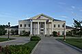
The Carlisle County Courthouse in Bardwell.
See also
 In Spanish: Condado de Carlisle para niños
