Graves County, Kentucky facts for kids
Quick facts for kids
Graves County
|
|
|---|---|

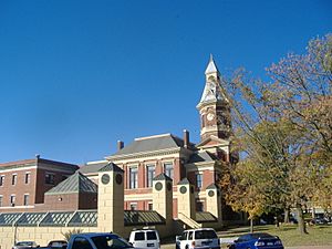
Graves County Courthouse in Mayfield in 2008,
part of the Mayfield Downtown Commercial District; building sustained major damage in a long-tracked tornado on December 10, 2021. |
|

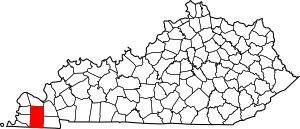
Location within the U.S. state of Kentucky
|
|
 Kentucky's location within the U.S. |
|
| Country | |
| State | |
| Founded | 1824 |
| Named for | Benjamin F. Graves |
| Seat | Mayfield |
| Largest city | Mayfield |
| Area | |
| • Total | 557 sq mi (1,440 km2) |
| • Land | 552 sq mi (1,430 km2) |
| • Water | 5.0 sq mi (13 km2) 0.9%% |
| Population
(2020)
|
|
| • Total | 36,649 |
| • Estimate
(2023)
|
36,461 |
| • Density | 65.80/sq mi (25.404/km2) |
| Time zone | UTC−6 (Central) |
| • Summer (DST) | UTC−5 (CDT) |
| Congressional district | 1st |
Graves County is a place in the U.S. state of Kentucky. It's located in the southwestern part of the state. In 2020, about 36,649 people lived there. The main town and county seat (the place where the county government is) is Mayfield.
Graves County was created in 1824. It was named after Major Benjamin Franklin Graves. He was a politician and a brave soldier who died in the War of 1812.
Graves County is part of a larger area called the Mayfield, KY Micropolitan Statistical Area. This area is also connected to Paducah, Kentucky, and Illinois.
Graves County has special rules about selling alcohol. It's a "limited" dry county. This means that most alcohol sales are not allowed. However, some restaurants can sell wine and beer. In 2016, the people of Mayfield voted to allow alcohol sales in stores and gas stations within the city limits.
Contents
Discovering Graves County's Past
Graves County got its name from Captain Benjamin Franklin Graves. He was a brave officer from Kentucky. He was captured during the War of 1812 in a terrible battle called the Battle of Raisin River in 1813. Sadly, he disappeared while being forced to walk by Native American warriors. They sometimes killed prisoners who couldn't keep up. Many Kentuckians died in this battle.
Graves County is one of the biggest counties in Kentucky. Its rich, fertile land attracted many early settlers. These settlers came from places like Virginia, North Carolina, South Carolina, and Tennessee. They brought their education and strong will to succeed. They helped create a unique community in Graves County.
Farming and Factories: Growing the Economy
Tobacco was a very important crop for the local economy. Graves County became known for its special types of tobacco. These were used in smokeless tobacco products.
Before the Civil War, a woolen mill started operating in the county. This mill made cloth from wool. It grew as more men's clothing was needed. Later, several clothing manufacturing companies also opened in the area. The local baseball team in Mayfield was even called the Mayfield Clothiers. This name honored the county's history in making clothes.
Notable People from Graves County
Many important people have come from Graves County. These include a U.S. Vice President and several U.S. Congressmen. The county has also been home to famous heroes, singers, songwriters, and writers. There are many historic sites to visit in the county.
Exploring Graves County's Geography
Graves County covers a total area of about 557 square miles. Most of this area, about 552 square miles, is land. The rest, about 5.0 square miles, is water.
Neighboring Counties and States
Graves County shares its borders with several other counties and states:
- McCracken County (to the north)
- Marshall County (to the northeast)
- Calloway County (to the southeast)
- Henry County, Tennessee (to the southeast)
- Weakley County, Tennessee (to the south)
- Hickman County (to the southwest)
- Carlisle County (to the northwest)
Protected Natural Areas
Part of the Clarks River National Wildlife Refuge is located in Graves County. This is a special area that protects wildlife and their homes.
Understanding Graves County's Population
| Historical population | |||
|---|---|---|---|
| Census | Pop. | %± | |
| 1830 | 2,504 | — | |
| 1840 | 7,465 | 198.1% | |
| 1850 | 11,397 | 52.7% | |
| 1860 | 16,233 | 42.4% | |
| 1870 | 19,398 | 19.5% | |
| 1880 | 24,138 | 24.4% | |
| 1890 | 28,534 | 18.2% | |
| 1900 | 33,204 | 16.4% | |
| 1910 | 33,539 | 1.0% | |
| 1920 | 32,483 | −3.1% | |
| 1930 | 30,778 | −5.2% | |
| 1940 | 31,763 | 3.2% | |
| 1950 | 31,364 | −1.3% | |
| 1960 | 30,021 | −4.3% | |
| 1970 | 30,939 | 3.1% | |
| 1980 | 34,049 | 10.1% | |
| 1990 | 33,550 | −1.5% | |
| 2000 | 37,028 | 10.4% | |
| 2010 | 37,121 | 0.3% | |
| 2020 | 36,649 | −1.3% | |
| 2023 (est.) | 36,461 | −1.8% | |
| U.S. Decennial Census 1790-1960 1900-1990 1990-2000 2010-2020 |
|||
In 2000, there were 37,028 people living in Graves County. The population density was about 67 people per square mile. This means that, on average, 67 people lived in every square mile of land.
About 24.5% of the people were under 18 years old. The median age was 38 years. This means half the people were younger than 38, and half were older.
Communities in Graves County
Graves County has several towns and communities.
Cities
- Mayfield (This is the county seat)
- Water Valley
- Wingo
Other Communities
Many other smaller communities are located in Graves County. Some of these include:
- Fancy Farm
- Farmington
- Hickory
- Lowes
- Pryorsburg
- Sedalia
- Symsonia
- Bell City
- Boaz
- Clear Springs
- Cuba
- Dogwood
- Dublin
- Dukedom (partly in Tennessee)
- Feliciana
- Folsomdale
- Golo
- Kaler
- Lynnville
- Melber
- Pottsville
- South Highland
- Stubblefield
- Viola
- West Viola
- Westplains
See also
 In Spanish: Condado de Graves para niños
 | Selma Burke |
 | Pauline Powell Burns |
 | Frederick J. Brown |
 | Robert Blackburn |

