Calloway County, Kentucky facts for kids
Quick facts for kids
Calloway County
|
|||
|---|---|---|---|

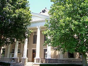
Calloway County courthouse in Murray
|
|||
|
|||

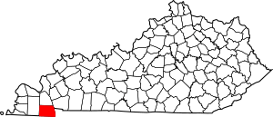
Location within the U.S. state of Kentucky
|
|||
 Kentucky's location within the U.S. |
|||
| Country | |||
| State | |||
| Founded | November 3, 1822 | ||
| Named for | Richard Callaway | ||
| Seat | Murray | ||
| Largest city | Murray | ||
| Area | |||
| • Total | 411 sq mi (1,060 km2) | ||
| • Land | 385 sq mi (1,000 km2) | ||
| • Water | 26 sq mi (70 km2) 6.3%% | ||
| Population
(2020)
|
|||
| • Total | 37,103 | ||
| • Estimate
(2023)
|
38,280 |
||
| • Density | 90.27/sq mi (34.86/km2) | ||
| Time zone | UTC−6 (Central) | ||
| • Summer (DST) | UTC−5 (CDT) | ||
| Congressional district | 1st | ||
Calloway County is a county in the U.S. state of Kentucky. It is located on the southwest border of the state. In 2020, about 37,103 people lived there.
The main town and county seat is Murray. The county was started in November 1822. It was named after Colonel Richard Callaway. He was one of the people who helped start Boonesborough. Calloway County is part of the Murray, KY area. In most of Calloway County, alcohol sales are not allowed, except for the city of Murray.
Contents
History of Calloway County
Calloway County was formed in 1822. The land for the county came from Hickman County. The first courthouse was built in 1823.
Sadly, a fire at the courthouse in 1906 destroyed almost all the county's old records. The county is named after Richard Callaway.
Geography of the County
Calloway County covers a total area of about 411 square miles. Most of this area, about 385 square miles, is land. The rest, about 26 square miles, is water. This means about 6.3% of the county is covered by water.
Neighboring Counties
Calloway County shares its borders with several other counties:
- Marshall County (to the north)
- Trigg County (to the northeast)
- Stewart County, Tennessee (to the southeast)
- Henry County, Tennessee (to the south)
- Graves County (to the west)
Protected Natural Areas
A part of Fort Donelson National Battlefield is located here. This part is called Fort Heiman.
Population Information
| Historical population | |||
|---|---|---|---|
| Census | Pop. | %± | |
| 1830 | 5,164 | — | |
| 1840 | 9,794 | 89.7% | |
| 1850 | 8,096 | −17.3% | |
| 1860 | 9,915 | 22.5% | |
| 1870 | 9,410 | −5.1% | |
| 1880 | 13,295 | 41.3% | |
| 1890 | 14,675 | 10.4% | |
| 1900 | 17,633 | 20.2% | |
| 1910 | 19,867 | 12.7% | |
| 1920 | 20,802 | 4.7% | |
| 1930 | 17,662 | −15.1% | |
| 1940 | 19,041 | 7.8% | |
| 1950 | 20,147 | 5.8% | |
| 1960 | 20,972 | 4.1% | |
| 1970 | 27,692 | 32.0% | |
| 1980 | 30,031 | 8.4% | |
| 1990 | 30,735 | 2.3% | |
| 2000 | 34,177 | 11.2% | |
| 2010 | 37,191 | 8.8% | |
| 2020 | 37,103 | −0.2% | |
| 2023 (est.) | 38,280 | 2.9% | |
| U.S. Decennial Census 1790-1960 1900-1990 1990-2000 2010-2020 |
|||
In 2000, there were 34,177 people living in Calloway County. The population density was about 88 people per square mile. The median age of people in the county was 34 years old. Many young people aged 18 to 24 live here because of Murray State University.
Towns and Communities
Calloway County has several towns and smaller communities.
Cities in Calloway County
Special Census Place
- Dexter is a place defined for census purposes.
Other Small Communities
- Almo
- Backusburg
- Bethel
- Blood
- Boatwright
- Coldwater
- Crossland
- Elm Grove
- Faxon
- Hamlin
- Harris Grove
- Hico
- Kirksey
- Lynn Grove
- Midway
- New Concord
- Penny
- Protemus
- Shiloh
- Stella
- Wadesboro
- Wiswell
Interesting Places to Visit
- Fort Heiman is a part of the Fort Donelson National Battlefield. It is a historical site.
Famous People from Calloway County
Many notable people have come from Calloway County:
- W. Earl Brown, an actor and musician
- T.R.M. Howard, a surgeon and civil rights leader
- Joe Staton, a cartoonist
- Frank Stubblefield, a politician
- Nathan Stubblefield, an inventor
- Harry Lee Waterfield, a politician
- Molly Sims, an actress and model
- Cleanth Brooks, a professor and literary critic
- Mel Purcell, a professional tennis player
- Jackie DeShannon, a singer-songwriter from the 1960s
- Tim Masthay, an NFL Punter and Super Bowl Champion
See also
 In Spanish: Condado de Calloway para niños
 | James Van Der Zee |
 | Alma Thomas |
 | Ellis Wilson |
 | Margaret Taylor-Burroughs |


