Puxico, Missouri facts for kids
Quick facts for kids
Puxico, Missouri
|
|
|---|---|

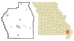
Location of Puxico, Missouri
|
|
| Country | United States |
| State | Missouri |
| County | Stoddard |
| Area | |
| • Total | 0.67 sq mi (1.75 km2) |
| • Land | 0.67 sq mi (1.73 km2) |
| • Water | 0.01 sq mi (0.02 km2) |
| Elevation | 374 ft (114 m) |
| Population
(2020)
|
|
| • Total | 873 |
| • Density | 1,310.81/sq mi (505.92/km2) |
| Time zone | UTC-6 (Central (CST)) |
| • Summer (DST) | UTC-5 (CDT) |
| ZIP code |
63960
|
| Area code(s) | 573 |
| FIPS code | 29-60284 |
| GNIS feature ID | 2396295 |
| Website | http://www.puxicomo.us/ |
Puxico is a city located in Stoddard County, Missouri, in the United States. In 2010, about 881 people lived there. By 2020, the population was 873.
Contents
History of Puxico
Puxico was first settled in 1883. It was named after an Indian chief called Pucksicah. Some of the first people to settle here were W. C. Clark, E.L Hawks, George Eaton, and J.A Hickman.
A post office opened in Puxico in 1884. The city was officially made a town in the same year.
Puxico Homecoming Festival
Puxico is famous for its yearly event called Homecoming. This festival started during the Great Depression. The Booster Club created it to bring the community together.
After World War II, soldiers who returned home formed the VFW Post. They took over the Homecoming tradition.
A special food at the event is goat burgers. They have been served since the late 1930s.
The Homecoming festival also includes fun activities. There is a carnival fair, square dancing, and beauty pageants. A big parade is also part of the celebration. It takes place every August, from the second Tuesday to Saturday.
Geography of Puxico
Puxico is located at 36°57′2″N 90°9′31″W / 36.95056°N 90.15861°W.
The United States Census Bureau says the city covers about 0.68 square miles (1.75 square kilometers). Most of this area, about 0.67 square miles (1.73 square kilometers), is land. A small part, about 0.01 square miles (0.02 square kilometers), is water.
Population Changes in Puxico
| Historical population | |||
|---|---|---|---|
| Census | Pop. | %± | |
| 1890 | 212 | — | |
| 1900 | 413 | 94.8% | |
| 1910 | 814 | 97.1% | |
| 1920 | 877 | 7.7% | |
| 1930 | 766 | −12.7% | |
| 1940 | 792 | 3.4% | |
| 1950 | 749 | −5.4% | |
| 1960 | 743 | −0.8% | |
| 1970 | 759 | 2.2% | |
| 1980 | 833 | 9.7% | |
| 1990 | 819 | −1.7% | |
| 2000 | 1,145 | 39.8% | |
| 2010 | 881 | −23.1% | |
| 2020 | 873 | −0.9% | |
| U.S. Decennial Census | |||
Puxico's Population in 2010
In 2010, the census showed that 881 people lived in Puxico. There were 364 households, which are groups of people living together. About 227 of these were families.
The city had about 1315 people per square mile (506 people per square kilometer). There were 429 homes.
About 24% of the people were under 18 years old. About 23% were 65 years old or older. The average age in the city was 40.6 years.
Education in Puxico
The Puxico R-VIII School District manages public schools in Puxico.
Puxico also has a public library. It is called the Puxico Public Library. Here, people can borrow books and other materials.
Climate in Puxico
Puxico has a type of weather called a humid subtropical climate. This means the area has warm temperatures and rain throughout the year. On climate maps, this is shown as "Cfa".
See also
 In Spanish: Puxico (Misuri) para niños
 | Victor J. Glover |
 | Yvonne Cagle |
 | Jeanette Epps |
 | Bernard A. Harris Jr. |

