Baker, Missouri facts for kids
Quick facts for kids
Baker, Missouri
|
|
|---|---|
|
Village
|
|

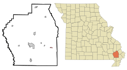
Location of Baker, Missouri
|
|
| Country | United States |
| State | Missouri |
| County | Stoddard |
| Area | |
| • Total | 0.20 sq mi (0.53 km2) |
| • Land | 0.20 sq mi (0.53 km2) |
| • Water | 0.00 sq mi (0.00 km2) |
| Elevation | 292 ft (89 m) |
| Population
(2020)
|
|
| • Total | 3 |
| • Density | 14.63/sq mi (5.64/km2) |
| Time zone | UTC-6 (Central (CST)) |
| • Summer (DST) | UTC-5 (CDT) |
| FIPS code | 29-03034 |
| GNIS feature ID | 2398019 |
Baker is a very small village in Stoddard County, Missouri, United States. It's so small that it's considered an inactive village. According to the 2020 census, only 3 people lived there! This makes Baker the smallest incorporated village in Missouri.
Contents
Where is Baker, Missouri?
Baker is located right next to the Castor River. You can find it along Missouri Route HH. It's about 10 miles east of Dexter. It's also about 11 miles southwest of Sikeston.
The village covers a total area of about 0.21 square miles (0.53 square kilometers). All of this area is land.
Baker is special because it's very close to four different states. It is only 28.6 miles from Arkansas. It's 28.2 miles from Illinois. Tennessee is 23 miles away, and Kentucky is 18 miles away.
How Many People Live in Baker?
The number of people living in Baker has changed a lot over the years.
| Historical population | |||
|---|---|---|---|
| Census | Pop. | %± | |
| 1960 | 114 | — | |
| 1970 | 72 | −36.8% | |
| 1980 | 31 | −56.9% | |
| 1990 | 8 | −74.2% | |
| 2000 | 5 | −37.5% | |
| 2010 | 3 | −40.0% | |
| 2020 | 3 | 0.0% | |
| U.S. Decennial Census 2010 2020 |
|||
Baker's Population in 2020
In 2020, the U.S. Census counted 3 people living in Baker.
| Race / Ethnicity (NH = Non-Hispanic) | Pop 2010 | Pop 2020 | % 2010 | % 2020 |
|---|---|---|---|---|
| White alone (NH) | 3 | 2 | 100.00% | 66.67% |
| Black or African American alone (NH) | 0 | 0 | 0.00% | 0.00% |
| Native American or Alaska Native alone (NH) | 0 | 0 | 0.00% | 0.00% |
| Asian alone (NH) | 0 | 0 | 0.00% | 0.00% |
| Pacific Islander alone (NH) | 0 | 0 | 0.00% | 0.00% |
| Some Other Race alone (NH) | 0 | 0 | 0.00% | 0.00% |
| Mixed Race orMulti-Racial (NH) | 0 | 0 | 0.00% | 0.00% |
| Hispanic or Latino (any race) | 0 | 1 | 0.00% | 33.33% |
| Total | 3 | 3 | 100.00% | 100.00% |
Baker's Population in 2010
In 2010, there were also 3 people living in Baker. They lived in just 1 household. This household was a married couple living together.
The average age of people in the village was 60.5 years. About one-third of the residents were between 25 and 44 years old. Another third were between 45 and 64 years old. The final third were 65 years or older. Most of the residents were male.
Images for kids
See also
 In Spanish: Baker (Misuri) para niños


