Clayton, Missouri facts for kids
Quick facts for kids
Clayton, Missouri
|
|
|---|---|
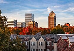
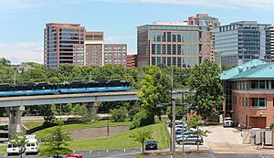
Clayton high-rises seen from the Moorlands
|
|
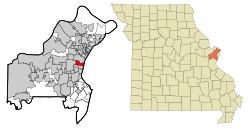
Location in Missouri
|
|
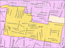
U.S. Census Map
|
|
| Country | United States |
| State | Missouri |
| County | St. Louis |
| Settled | 1877 |
| Incorporated | 1913 |
| Government | |
| • Type | Mayor-council city |
| Area | |
| • Total | 2.51 sq mi (6.49 km2) |
| • Land | 2.51 sq mi (6.49 km2) |
| • Water | 0.00 sq mi (0.00 km2) |
| Elevation | 551 ft (168 m) |
| Population
(2020)
|
|
| • Total | 17,355 |
| • Density | 6,919.9/sq mi (2,671.8/km2) |
| Time zone | UTC-6 (Central) |
| • Summer (DST) | UTC-5 (Central) |
| ZIP code |
63105
|
| Area code(s) | 314 |
| FIPS code | 29-14572 |
| GNIS feature ID | 2393548 |
| Website | City of Clayton |
Clayton is a city in Missouri, USA. It's the main city of St. Louis County. Clayton is right next to the big city of St. Louis. In 2020, about 17,355 people lived here. The city started in 1877. It was named after Ralph Clayton, who gave the land for the St. Louis County courthouse.
Contents
What does Clayton look like?
Cityscape and Buildings
The buildings in central Clayton show its history and growth. You can see many modern buildings, both short and tall. These stand out next to older mansions, shops, and apartments. The neighborhoods around the city center are great for walking. They have lots of brick homes, apartment buildings, and even some grand houses. Many small shopping areas are also found here.
Neighborhoods in Clayton
Clayton has several unique neighborhoods. Each one has its own feel and features.
Claverach Park
Claverach Park is a neighborhood with homes. It was planned in the 1920s. The streets are curvy and lined with trees. It has one main park and nine smaller "pocket parks." Oak Knoll Park, one of Clayton's biggest parks, is also in this area.
Clayshire
Clayshire is a neighborhood with a more suburban feel. It has parks like Anderson Park and Whitburn Park. There's also a small shopping area at Clayton Road and Brentwood Boulevard.
Davis Place
Davis Place is a large neighborhood mostly with single-family homes. You can also find some apartment buildings here. The "Shops of Clayton" are a popular commercial area in Davis Place.
DeMun
DeMun is a neighborhood on the eastern side of Clayton. It's a busy area where you can walk to many places. It has old brick apartment buildings and homes. You'll also find small shops along DeMun Avenue. Concordia Seminary and part of Washington University are located here. There are three public parks: Concordia, DeMun, and Henry Wright.
Downtown Clayton
Downtown Clayton is the center of government for St. Louis County. It's also a major business hub. Many large companies have their main offices here. These include Centene Corporation, Emerson Electric, and Graybar. Downtown Clayton is famous for its many restaurants and cafes. It also hosts the St. Louis Art Fair every September. New buildings are often being built in this area.
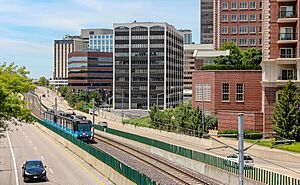
You can get to downtown Clayton using the MetroLink train system. The Blue Line stops at the Clayton and Forsyth stations.
Moorlands
The Moorlands is another neighborhood where you can walk easily. It has many older apartment buildings and homes. There are also tall apartment buildings along Hanley Road. A small shopping area is located at Hanley and Wydown Boulevard.
North Clayton
North Clayton is a busy area with many homes. It also has offices, apartments, and condos. You can find shops along Meramec and Maryland avenues. This neighborhood is home to Kol Rinah synagogue and St. Joseph Catholic Church. The Mid County branch of the St. Louis County Library is also here. Parks include Taylor Park and Hanley Park, which has the historic Hanley House.
People and Population
Clayton is known for having many educated people. Many residents work in professional jobs.
| Historical population | |||
|---|---|---|---|
| Census | Pop. | %± | |
| 1890 | 402 | — | |
| 1920 | 3,028 | — | |
| 1930 | 9,613 | 217.5% | |
| 1940 | 13,069 | 36.0% | |
| 1950 | 16,035 | 22.7% | |
| 1960 | 15,245 | −4.9% | |
| 1970 | 16,100 | 5.6% | |
| 1980 | 14,219 | −11.7% | |
| 1990 | 13,874 | −2.4% | |
| 2000 | 12,825 | −7.6% | |
| 2010 | 15,939 | 24.3% | |
| 2020 | 17,355 | 8.9% | |
| U.S. Decennial Census | |||
Population in 2020
In 2020, Clayton had 17,355 people living there. Most residents were white (71.37%). There were also significant numbers of black (8.07%) and Asian (12.88%) residents. About 3.6% of the population was Hispanic or Latino.
The average age in Clayton was about 29.5 years old. Many young adults (18-24 years old) live in the city.
Economy and Jobs
Clayton is one of the biggest business areas in the St. Louis region. It has about 46,000 people working there each day. Many large companies, law firms, and banks are based in Clayton.
Some of the biggest employers in Clayton include:
- Centene (a healthcare company)
- St. Louis County government
- Enterprise Holdings (a car rental company)
- Washington University
- Caleres (a shoe company)
- Commerce Bank
- School District of Clayton
Getting Around Clayton
Public Transportation
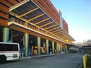
Clayton has a public train system called MetroLink. The Blue Line serves the city. It has two stations: Clayton and Forsyth. There's also the Clayton Transit Center. This center connects the train station to many MetroBus routes.
Main Roads
Major roads in Clayton include Big Bend Boulevard, Brentwood Boulevard, and Clayton Road. Interstate 170 also runs through the city. Forsyth Boulevard was once an old Native American trail. It was even part of the route for the marathon in the 1904 Olympic Games.
Education in Clayton
Colleges and Universities
Clayton is home to Fontbonne University and Concordia Seminary. Part of Washington University's campus, called the South 40, is also in Clayton. This area mainly has student housing. Washington University also has offices in downtown Clayton.
Schools for Kids
The public schools in Clayton are run by the School District of Clayton. This district covers the entire city. There are three public elementary schools: Glenridge, Captain, and Merameac. These schools lead to Wydown Middle School. After middle school, students go to Clayton High School. In 2021, about 2,412 students were in the district.
Public Libraries
The St. Louis County Library has a branch in Clayton called the Mid-County Branch. It was rebuilt and opened again in 2020.
Parks and Fun Activities
Shaw Park is the biggest park in Clayton, covering 30 acres. It has a large swimming pool, tennis courts, and an ice rink. You can also find a baseball field, volleyball courts, and a playground. The park hosts Clayton's Independence Day party and a food festival.
Oak Knoll Park is the second largest park. It used to be home to the Academy of Science.
Clayton also has many smaller neighborhood parks. These include Anderson Park, DeMun Park, and Hanley Park. The city is also part of the Centennial Greenway. This is a trail system that connects Clayton to other areas and to Forest Park in St. Louis.
See also
 In Spanish: Clayton (Misuri) para niños
 | Chris Smalls |
 | Fred Hampton |
 | Ralph Abernathy |


