
Phelps County, Missouri facts for kids
Quick facts for kids
Phelps County
|
|
|---|---|

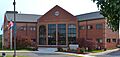
New Phelps County courthouse in Rolla
|
|

Location within the U.S. state of Missouri
|
|
 Missouri's location within the U.S. |
|
| Country | |
| State | |
| Founded | November 13, 1857 |
| Named for | John S. Phelps |
| Seat | Rolla |
| Largest city | Rolla |
| Area | |
| • Total | 674 sq mi (1,750 km2) |
| • Land | 672 sq mi (1,740 km2) |
| • Water | 2.5 sq mi (6 km2) 0.4% |
| Population
(2020)
|
|
| • Total | 44,638 |
| • Density | 66.23/sq mi (25.571/km2) |
| Time zone | UTC−6 (Central) |
| • Summer (DST) | UTC−5 (CDT) |
| Congressional district | 8th |

Phelps County is a county located in the middle part of Missouri, a state in the United States. In 2020, about 44,638 people lived here. The biggest city and the main government center, called the county seat, is Rolla.
Phelps County was created on November 13, 1857. It was named after John Smith Phelps, who was a U.S. Representative and later the Governor of Missouri.
The county is part of the Rolla, Missouri, area. It is also known for its vineyards and wineries. Italian immigrants first started growing grapes and making wine in Rolla. Since the 1960s, winemakers in Missouri have brought back and created many new vineyards. They have even won awards for their wines!
The first Phelps County Court meeting happened on November 25, 1857. It took place in a simple cabin. The old courthouse building was started in 1860. During the American Civil War, it was used as a hospital. It served as the courthouse until 1994, when a new building was opened.
Contents
History of Phelps County
European settlers started farms along the rivers in this area around 1818 and 1819.
A few years later, in 1853, Edmund Ward Bishop came to the area. He was a contractor building a railroad line called the "Frisco Branch of the Southwest Railroad." Bishop later founded the city of Rolla.
Phelps County was officially created on November 13, 1857. It was formed from parts of Pulaski, Maries, and Crawford counties. A special group was chosen to pick the county seat. They were told to find a spot on the railroad line, close to the center of the county.
Edmund Ward Bishop offered about 50 acres (200,000 m²) of land for the main town site, and it was accepted. There was some disagreement about where the county seat should be. People from the west side wanted Rolla, and those from the east wanted Dillon. The state government finally made Rolla the official county seat in 1861.
Rolla was officially mapped out and named in 1858. Bishop wanted to call it "Phelps Center." Another settler, George Coppedge, suggested "Raleigh" after his hometown. Others agreed, but they wanted to spell it "Rolla."
The town of Rolla didn't really exist when the county was created in November 1857. Only a couple of houses were there. Early court meetings focused on building roads from the county seat to other places. These included St. Louis, Springfield, and Jefferson City. The name "Rolla" first appeared in court records in July 1858.
In April 1859, the county court ordered the 50 acres (200,000 m²) donated by Mr. Bishop to be surveyed. This survey was finished in May 1859.
Civil War in Phelps County
The railroad's first train arrived in Rolla on December 22, 1860. This made Rolla the end of the line for a while. All goods were loaded onto wagons here and sent to places like Springfield.
During the American Civil War, Rolla became a very important military base. Up to 20,000 Union soldiers were stationed there. The Phelps County Courthouse was even turned into a hospital during the war.
In April 1861, the war began. Some people in Rolla supported the South. On May 10, a heated debate about leaving the Union caused a court meeting to break up. A group of men took down the United States flag and put up a Confederate flag. Union supporters were sometimes told to leave town.
However, on June 14, General Franz Sigel arrived by train with his soldiers and took control of the town. From that day until the end of the war, Rolla stayed under Union control.
President Abraham Lincoln himself ordered that Rolla must be held by the Union. Because it was at the end of the railroad, military supplies were sent from Rolla to Union armies fighting in Arkansas and other parts of Missouri.
Rolla was a key spot during the Civil War because it was the end of the railroad line. Thousands of Union troops and their supplies came to Rolla by train from St. Louis. Then, they were moved by wagons to battlefields like Wilson Creek and Pea Ridge. The war stopped the railroad from expanding further west.
The town had about 600 people, but many Union soldiers were there. The Union forces controlled the town early in the war, which greatly affected how the town operated.
After a Union defeat in August 1861, the Union Army built an earthen fort near Rolla. It had a dry ditch around it and cannons to protect against attacks. This fort was named Fort Wyman. Later, in 1863, a more detailed fort called Fort Dette was built. It was shaped like a cross and had spots for cannons and rifles.
University in Phelps County
In 1862, the U.S. Congress passed a law called the Morrill Land-Grant College Act. This law helped states create new types of colleges. These colleges would teach subjects like agriculture (farming) and mechanical arts (engineering).
The Missouri School of Mines and Metallurgy was founded in 1870. This area was rich in minerals, and the location was good. Phelps County offered a large amount of money and land to get the school. Today, this school is called Missouri University of Science and Technology (Missouri S&T). It is known as one of the best engineering schools in the world. It offers many different degrees in engineering and science.
Other Towns in Phelps County
Other towns in Phelps County include Newburg, which became a town in 1888, and St. James, which became a town in 1869. Arlington and Jerome were also towns for a while, starting in 1867, but they are not official towns anymore. Doolittle was the last town in Phelps County to be formed, in 1944. Edgar Springs became a town in the 1970s.
Geography
Phelps County covers a total area of 674 square miles (1,746 km²). Most of this, 672 square miles (1,741 km²), is land. Only about 2.5 square miles (6.5 km²) is water.
Neighboring Counties
- Maries County – northwest
- Gasconade County – northeast
- Crawford County – east
- Dent County – southeast
- Texas County – south
- Pulaski County – west
Main Roads
 Interstate 44
 U.S. Route 63
 U.S. Route 66 (1926–1979)
 Route 68
 Route 8
 Route 72
Other Natural Features
- Courtois Hills
- Maramec Spring
- Democrat Ridge
- Mark Twain National Forest, a protected area partly in Phelps County
- Slaughter Sink, the deepest sinkhole in the state
People and Population
| Historical population | |||
|---|---|---|---|
| Census | Pop. | %± | |
| 1860 | 5,714 | — | |
| 1870 | 10,506 | 83.9% | |
| 1880 | 12,568 | 19.6% | |
| 1890 | 12,636 | 0.5% | |
| 1900 | 14,194 | 12.3% | |
| 1910 | 15,796 | 11.3% | |
| 1920 | 14,941 | −5.4% | |
| 1930 | 15,308 | 2.5% | |
| 1940 | 17,437 | 13.9% | |
| 1950 | 21,504 | 23.3% | |
| 1960 | 25,396 | 18.1% | |
| 1970 | 29,481 | 16.1% | |
| 1980 | 33,633 | 14.1% | |
| 1990 | 35,248 | 4.8% | |
| 2000 | 39,825 | 13.0% | |
| 2010 | 45,156 | 13.4% | |
| 2020 | 44,638 | −1.1% | |
| US Decennial Census 1790-1960 1900-1990 1990-2000 2010-2020 |
|||
In 2000, there were 39,825 people living in Phelps County. The average number of people per square mile was about 59. Most people (93.24%) were White. Other groups included Black or African American (1.50%), Native American (0.59%), and Asian (2.35%). About 1.22% of the population was Hispanic or Latino.
The average age of people in the county was 35 years old. For every 100 females, there were about 103 males.
Religion in Phelps County
Phelps County is part of an area known as the Bible Belt. This means that many people here follow evangelical Protestant religions. The largest religious groups include Southern Baptists, Roman Catholics, and Christian Churches & Churches of Christ.
2020 Census Information
| Race | Num. | Perc. |
|---|---|---|
| White (NH) | 37,941 | 85% |
| Black or African American (NH) | 1,028 | 2.3% |
| Native American (NH) | 231 | 0.52% |
| Asian (NH) | 1,506 | 3.37% |
| Pacific Islander (NH) | 20 | 0.04% |
| Other/Mixed (NH) | 2,653 | 6% |
| Hispanic or Latino | 1,259 | 2.82% |
Education
In Phelps County, about 79% of adults aged 25 and older have a high school diploma or higher. About 21% have a bachelor's degree or higher.
Public Schools
- Newburg R-II School District - Newburg
- Newburg Elementary School (Grades K-6)
- Newburg High School (Grades 7-12)
- Phelps County R-III School District - Edgar Springs
- Phelps County Elementary School (Grades K-8)
- Rolla School District 31 - Rolla
- Colonel John B. Wyman Elementary School (Pre K-3)
- Harry S. Truman Elementary School (Pre K-3)
- Mark Twain Elementary School (Pre K-3)
- Rolla Middle School (Grades 4-6)
- Rolla Junior High School (Grades 7-8)
- Rolla High School (Grades 9-12)
- St. James R-I School District - St. James
- Lucy Wortham Elementary School (Grades K-5)
- St. James Middle School (Grades 6-8)
- St. James High School (Grades 9-12)
Private Schools
- KVC Missouri School - St. James - (Grades 1-12) - Not connected to a religion
- Rolla Seventh-day Adventist School - Rolla - (Grades K-7) - Seventh-day Adventist
- St. Patrick Elementary School - Rolla - (Grades PK-8) - Roman Catholic
Other Schools
- B.W. Robinson State School - Rolla - (Grades K-12) - Special Education
- Rolla Technical Center - Rolla - (Grades 11-12) - Teaches job skills
- Rolla Technical Institute High School - Rolla - (Grades 9-12) - Teaches job skills
Colleges & Universities
- Missouri University of Science and Technology - Formerly known as the University of Missouri-Rolla (UMR) - Rolla - A public, four-year university.
- Drury University - Rolla - A smaller campus location.
- East Central College - Rolla - A smaller campus location.
- Columbia College - Rolla - A smaller campus location.
Public Libraries
- James Memorial Library
- Newburg Public Library
- Rolla Public Library
Communities
Cities and Towns
- Doolittle
- Edgar Springs
- Newburg
- Rolla (county seat)
- St. James
Unincorporated Communities
Images for kids
-
New Phelps County courthouse in Rolla
See also
 In Spanish: Condado de Phelps (Misuri) para niños
