Howell County, Missouri facts for kids
Quick facts for kids
Howell County
|
|
|---|---|

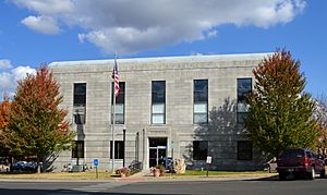
Howell County Courthouse in West Plains
|
|

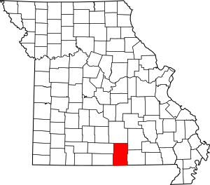
Location within the U.S. state of Missouri
|
|
 Missouri's location within the U.S. |
|
| Country | |
| State | |
| Founded | March 2, 1857 |
| Named for | Josiah Howell |
| Seat | West Plains |
| Largest city | West Plains |
| Area | |
| • Total | 928 sq mi (2,400 km2) |
| • Land | 927 sq mi (2,400 km2) |
| • Water | 1.1 sq mi (3 km2) 0.1% |
| Population
(2020)
|
|
| • Total | 39,750 |
| • Density | 42.834/sq mi (16.538/km2) |
| Time zone | UTC−6 (Central) |
| • Summer (DST) | UTC−5 (CDT) |
| Congressional district | 8th |
Howell County is a county located in the southern part of Missouri, a state in the United States. In 2020, about 39,750 people lived here. The biggest city and the main government center, called the county seat, is West Plains. Howell County was officially created on March 2, 1851. It was named after Josiah Howell, who was one of the first settlers in the area known as Howell Valley.
Howell County is part of the West Plains, MO, Micropolitan Statistical Area. This means it's a smaller city area that is closely connected to a larger city, even if it's not huge itself.
Contents
History of Howell County
Howell County was formed on March 2, 1857. It was created from a part of Oregon County. The county got its name from Josiah Howell, who was the first person to settle in the Howell Valley.
The very first court meetings for the county took place in a simple log cabin. This cabin was about one mile east of West Plains. Later, in 1859, a small wooden courthouse was built in West Plains. Sadly, this building was damaged during the American Civil War in 1862.
After the war, the county government was restarted three years later. However, all the county records were lost in a fire in 1866. A second courthouse was then built in West Plains in 1869. This building was also small, with just three rooms, and measured about 24 by 30 feet.
Geography and Nature
Howell County covers a total area of about 928 square miles. Most of this area, about 927 square miles, is land. Only a small part, about 1.1 square miles, is water. This makes Howell County the third-largest county in Missouri by land area. It's also the fourth-largest by its total area.
Neighboring Counties
Howell County shares its borders with several other counties:
- Texas County (to the north)
- Shannon County (to the northeast)
- Oregon County (to the east)
- Fulton County, Arkansas (to the south)
- Ozark County (to the southwest)
- Douglas County (to the northwest)
Main Roads
Several important highways pass through Howell County, making it easy to travel to and from the area:
 U.S. Route 60
 U.S. Route 63
 U.S. Route 160
 Route 14
 Route 17
 Route 76
 Route 142
Protected Natural Areas
A part of the Mark Twain National Forest is located within Howell County. This forest is a large protected area where people can enjoy nature.
People and Population
| Historical population | |||
|---|---|---|---|
| Census | Pop. | %± | |
| 1860 | 3,169 | — | |
| 1870 | 4,218 | 33.1% | |
| 1880 | 8,814 | 109.0% | |
| 1890 | 18,618 | 111.2% | |
| 1900 | 21,834 | 17.3% | |
| 1910 | 21,065 | −3.5% | |
| 1920 | 21,102 | 0.2% | |
| 1930 | 19,672 | −6.8% | |
| 1940 | 22,270 | 13.2% | |
| 1950 | 22,725 | 2.0% | |
| 1960 | 22,027 | −3.1% | |
| 1970 | 23,521 | 6.8% | |
| 1980 | 28,807 | 22.5% | |
| 1990 | 31,447 | 9.2% | |
| 2000 | 37,238 | 18.4% | |
| 2010 | 40,400 | 8.5% | |
| 2020 | 39,750 | −1.6% | |
| U.S. Decennial Census 1790-1960 1900-1990 1990-2000 2010 |
|||
In 2000, there were 37,238 people living in Howell County. The population density was about 40 people per square mile. Many families lived in the county, with about 58.8% being married couples.
The average age of people in the county was 38 years old. About 26% of the population was under 18 years old.
Religious Groups
Howell County is part of an area sometimes called the Bible Belt. This means that many people in the county follow evangelical Protestant religions. The most common religious groups in Howell County are Southern Baptists, Churches of Christ, and Roman Catholics.
2020 Census Information
| Race | Num. | Perc. |
|---|---|---|
| White (NH) | 35,972 | 90.5% |
| Black or African American (NH) | 180 | 0.45% |
| Native American (NH) | 265 | 0.67% |
| Asian (NH) | 217 | 0.55% |
| Pacific Islander (NH) | 17 | 0.04% |
| Other/Mixed (NH) | 2,203 | 5.54% |
| Hispanic or Latino | 896 | 2.25% |
Education in Howell County
Education is important in Howell County. About 73.4% of adults aged 25 and older have a high school diploma or higher. Also, 10.9% have earned a bachelor's degree or higher.
Public Schools
Howell County has several public school districts:
- Mountain View-Birch Tree R-III School District (in Mountain View)
- Birch Tree Elementary School (grades PK-06) - located in Shannon County
- Mountain View Elementary School (grades PK-06)
- Liberty Middle School (grades 07-08)
- Liberty High School (grades 09-12)
- West Plains R-VII School District (in West Plains)
- South Fork Elementary School (grades K-06)
- West Plains Elementary School (grades K-04)
- West Plains Middle School (grades 05-08)
- West Plains High School (grades 09-12)
- Willow Springs R-IV School District (in Willow Springs)
- Willow Springs Elementary School (grades PK-04)
- Willow Springs Middle School (grades 05-08)
- Willow Springs High School (grades 09-12)
- Fairview R-XI School District (in West Plains)
- Fairview Elementary School (grades K-08)
- Glenwood R-VIII School District (in West Plains)
- Glenwood Elementary School (grades PK-08)
- Howell Valley R-I School District (in West Plains)
- Howell Valley Elementary School (grades K-08)
- Junction Hill C-12 School District (in West Plains)
- Junction Hill Elementary School (grades K-08)
- Richards R-V School District (in West Plains)
- Richards Elementary School (grades K-08)
Private Schools
There are also private schools in the county:
- Faith Assembly Christian School (in West Plains) - for grades PK-12, connected to the Assemblies of God church.
- Ozarks Christian Academy (in West Plains) - for grades K-10, a non-denominational Protestant school.
- Trinity Christian Academy (in Mountain View) - for grades K-12, a Pentecostal school.
Specialized Schools
- Ozark Horizon State School (in West Plains) - This school helps students with special needs from kindergarten through 12th grade.
- South Central Career Center (in West Plains) - This center offers vocational and technical training for high school students (grades 09-12).
Colleges and Universities
- Missouri State University-West Plains - This is a branch campus of Missouri State University, offering higher education close to home.
Public Libraries
You can find public libraries in several communities:
- Mountain View Public Library
- West Plains Public Library
- Willow Springs Public Library
Communities in Howell County
Howell County has several cities and smaller communities where people live.
Cities
- Brandsville
- Mountain View
- West Plains (This is the main county seat)
- Willow Springs
Census-Designated Places
These are areas that are like towns but are not officially incorporated as cities:
Other Unincorporated Places
These are smaller communities that are not officially cities or census-designated places:
Townships
Townships are smaller divisions of the county, often used for local government or land organization:
- Benton
- Chapel
- Dry Creek
- Goldsberry
- Howell
- Hutton Valley
- Myatt
- Siloam Springs
- Sisson
- South Fork
- Spring Creek
- Willow Springs
See also
 In Spanish: Condado de Howell para niños
 | Valerie Thomas |
 | Frederick McKinley Jones |
 | George Edward Alcorn Jr. |
 | Thomas Mensah |

