Fulton County, Arkansas facts for kids
Quick facts for kids
Fulton County
|
|
|---|---|

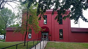
Fulton County Courthouse in Salem
|
|

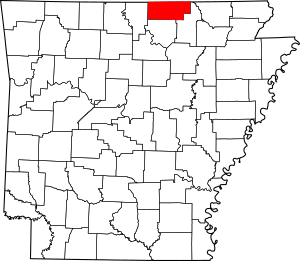
Location within the U.S. state of Arkansas
|
|
 Arkansas's location within the U.S. |
|
| Country | |
| State | |
| Founded | December 21, 1842 |
| Named for | William Fulton |
| Seat | Salem |
| Largest city | Salem |
| Area | |
| • Total | 620 sq mi (1,600 km2) |
| • Land | 618 sq mi (1,600 km2) |
| • Water | 2.1 sq mi (5 km2) 0.3%% |
| Population
(2020)
|
|
| • Total | 12,075 |
| • Density | 19.48/sq mi (7.52/km2) |
| Time zone | UTC−6 (Central) |
| • Summer (DST) | UTC−5 (CDT) |
| Congressional district | 1st |
Fulton County is a special area called a county in the state of Arkansas, USA. In 2020, about 12,075 people lived here. The main town, or county seat, is Salem. Fulton County was created on December 21, 1842. It was named after William Fulton, who was the last governor of the Arkansas Territory.
Contents
Exploring Fulton County's Geography
Fulton County covers a total area of about 620 square miles. Most of this area, about 618 square miles, is land. The rest, a small part of 2.1 square miles, is water.
Main Roads in Fulton County
Many important roads help people travel through Fulton County. These roads connect different towns and areas.
Neighboring Counties
Fulton County shares its borders with several other counties. Some are in Arkansas, and others are in Missouri.
- Ozark County, Missouri (to the northwest)
- Howell County, Missouri (to the north)
- Oregon County, Missouri (to the northeast)
- Sharp County (to the east)
- Izard County (to the south)
- Baxter County (to the west)
People and Population in Fulton County
The number of people living in Fulton County has changed over many years. Here's a look at how the population has grown and shifted.
| Historical population | |||
|---|---|---|---|
| Census | Pop. | %± | |
| 1850 | 1,819 | — | |
| 1860 | 4,024 | 121.2% | |
| 1870 | 4,843 | 20.4% | |
| 1880 | 6,720 | 38.8% | |
| 1890 | 10,984 | 63.5% | |
| 1900 | 12,917 | 17.6% | |
| 1910 | 12,193 | −5.6% | |
| 1920 | 11,182 | −8.3% | |
| 1930 | 10,834 | −3.1% | |
| 1940 | 10,253 | −5.4% | |
| 1950 | 9,187 | −10.4% | |
| 1960 | 6,657 | −27.5% | |
| 1970 | 7,699 | 15.7% | |
| 1980 | 9,975 | 29.6% | |
| 1990 | 10,037 | 0.6% | |
| 2000 | 11,642 | 16.0% | |
| 2010 | 12,245 | 5.2% | |
| 2020 | 12,075 | −1.4% | |
| 2023 (est.) | 12,421 | 1.4% | |
| U.S. Decennial Census 1790–1960 1900–1990 1990–2000 2010 |
|||
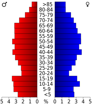
Fulton County's Population in 2020
In 2020, the 2020 United States census counted 12,075 people living in Fulton County. There were 4,973 households and 3,278 families. Most residents were White, making up about 92.76% of the population. Other groups included Black or African American, Native American, Asian, and people of mixed races. About 1.28% of the population was Hispanic or Latino.
| Race | Number | Percentage |
|---|---|---|
| White (non-Hispanic) | 11,201 | 92.76% |
| Black or African American (non-Hispanic) | 27 | 0.22% |
| Native American | 66 | 0.55% |
| Asian | 35 | 0.29% |
| Other/Mixed | 592 | 4.9% |
| Hispanic or Latino | 154 | 1.28% |
Learning in Fulton County: Schools
Fulton County has several public school districts. These districts provide education for students from elementary grades through high school.
- Mammoth Spring School District, which includes Mammoth Spring High School.
- Salem School District, which includes Salem High School.
- Viola School District, which includes Viola High School.
Towns and Communities
Fulton County is home to several towns and smaller communities. Each place has its own unique character.
Cities in Fulton County
- Ash Flat
- Cherokee Village
- Hardy
- Horseshoe Bend
- Mammoth Spring
- Salem (This is the county seat, the main town for county government.)
Town in Fulton County
Smaller Communities
These are smaller, unincorporated communities within Fulton County.
Townships: Local Areas
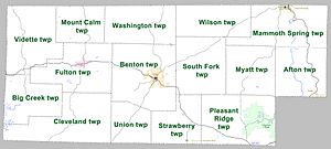
Fulton County is divided into smaller areas called townships. These are used for local administration.
Townships in Arkansas are the divisions of a county. Each township includes unincorporated areas; some may have incorporated cities or towns within part of their boundaries. Arkansas townships have limited purposes in modern times. However, the United States Census does list Arkansas population based on townships (sometimes referred to as "county subdivisions" or "minor civil divisions"). Townships are also of value for historical purposes in terms of genealogical research. Each town or city is within one or more townships in an Arkansas county based on census maps and publications. The townships of Fulton County are listed below; listed in parentheses are the cities, towns, and/or census-designated places that are fully or partially inside the township.
| Township | Population (2010) |
Total area (mi2) |
Land area (mi2) |
Water area (mi2) |
|||
|---|---|---|---|---|---|---|---|
| Afton | 650 | 37.587 | 97.35 | 37.252 | 96.48 | 0.335 | 0.8676 |
| Benton | 2,564 | 59.552 | 154.2 | 59.493 | 154.1 | 0.059 | 0.1528 |
| Big Creek | 428 | 34.167 | 88.49 | 33.398 | 86.50 | 0.769 | 1.992 |
| Cleveland | 514 | 54.677 | 141.6 | 54.450 | 141.0 | 0.227 | 0.5879 |
| Fulton | 1,049 | 46.115 | 119.4 | 45.968 | 119.1 | 0.147 | 0.3807 |
| Mammoth Spring | 2,035 | 50.584 | 131.0 | 50.430 | 130.6 | 0.154 | 0.3989 |
| Mount Calm | 207 | 26.627 | 68.96 | 26.611 | 68.92 | 0.016 | 0.04144 |
| Myatt | 191 | 35.792 | 92.70 | 35.766 | 92.63 | 0.026 | 0.06734 |
| Pleasant Ridge | 1,926 | 54.721 | 141.7 | 54.381 | 140.8 | 0.340 | 0.8806 |
| South Fork | 485 | 42.819 | 110.9 | 42.805 | 110.9 | 0.014 | 0.03626 |
| Strawberry | 742 | 30.591 | 79.23 | 30.558 | 79.14 | 0.033 | 0.08547 |
| Union | 303 | 23.158 | 59.98 | 23.158 | 59.98 | 0 | 0.000 |
| Vidette | 467 | 48.143 | 124.7 | 48.143 | 124.7 | 0 | 0.000 |
| Washington | 406 | 40.408 | 104.7 | 40.394 | 104.6 | 0.014 | 0.03626 |
| Wilson | 278 | 35.387 | 91.65 | 35.387 | 91.65 | 0 | 0.000 |
See also
 In Spanish: Condado de Fulton (Arkansas) para niños
 | Jackie Robinson |
 | Jack Johnson |
 | Althea Gibson |
 | Arthur Ashe |
 | Muhammad Ali |


