
Stone County, Missouri facts for kids
Quick facts for kids
Stone County
|
|
|---|---|

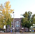
The Stone County Courthouse in Galena
|
|

Location within the U.S. state of Missouri
|
|
 Missouri's location within the U.S. |
|
| Country | |
| State | |
| Founded | February 10, 1851 |
| Named for | William Stone, English pioneer and an early settler in Maryland |
| Seat | Galena |
| Largest city | Kimberling City |
| Area | |
| • Total | 511 sq mi (1,320 km2) |
| • Land | 464 sq mi (1,200 km2) |
| • Water | 47 sq mi (120 km2) 9.2% |
| Population
(2020)
|
|
| • Total | 31,076 |
| • Density | 60.81/sq mi (23.480/km2) |
| Time zone | UTC−6 (Central) |
| • Summer (DST) | UTC−5 (CDT) |
| Congressional district | 7th |
Stone County is a county in the southwestern part of Missouri, a state in the United States. In 2020, about 31,076 people lived there. The main town, or county seat, is Galena. The biggest city in the county is Kimberling City.
Stone County used to be part of the Branson area.
Contents
History
Stone County was officially started on February 10, 1851. It was named after William Stone. He was an early settler from England who lived in Maryland. He also served as a judge in nearby Taney County.
Around 1904, a railway called the White River Railway was built. It went through the rough land of Stone and Taney counties. For many years, these counties had rules that did not allow African Americans to live there.
Geography
Stone County covers a total area of about 511 square miles. Most of this area, about 464 square miles, is land. The rest, about 47 square miles, is water. This means about 9.2% of the county is water.
Neighboring Counties
Stone County shares borders with several other counties:
- Christian County (to the north)
- Taney County (to the east)
- Carroll County (to the south)
- Barry County (to the west)
- Lawrence County (to the northwest)
Protected Natural Areas
Part of the Mark Twain National Forest is located in Stone County. This is a large area of protected land.
Population Information
| Historical population | |||
|---|---|---|---|
| Census | Pop. | %± | |
| 1860 | 2,400 | — | |
| 1870 | 3,253 | 35.5% | |
| 1880 | 4,404 | 35.4% | |
| 1890 | 7,090 | 61.0% | |
| 1900 | 9,892 | 39.5% | |
| 1910 | 11,559 | 16.9% | |
| 1920 | 11,941 | 3.3% | |
| 1930 | 11,614 | −2.7% | |
| 1940 | 11,298 | −2.7% | |
| 1950 | 9,748 | −13.7% | |
| 1960 | 8,176 | −16.1% | |
| 1970 | 9,921 | 21.3% | |
| 1980 | 15,587 | 57.1% | |
| 1990 | 19,078 | 22.4% | |
| 2000 | 28,658 | 50.2% | |
| 2010 | 32,202 | 12.4% | |
| 2020 | 31,076 | −3.5% | |
| U.S. Decennial Census 1790-1960 1900-1990 1990-2000 2010-2015 |
|||
In 2000, there were 28,658 people living in Stone County. There were 11,822 households, which are groups of people living together. The average age of people in the county was 44 years old.
Education
Many adults in Stone County have a good education. About 80.4% of adults aged 25 and older have a high school diploma or higher. Also, 14.2% have a bachelor's degree or more.
Public Schools
Stone County has several public school districts:
- Blue Eye R-V School District in Blue Eye
- Blue Eye Elementary School (grades PK-4)
- Blue Eye Middle School (grades 5-8)
- Blue Eye High School (grades 9-12)
- Crane R-III School District in Crane
- Crane Elementary School (grades K-6)
- Crane High School (grades 7-12)
- Galena R-II School District in Galena
- Galena-Abesville Elementary School (grades PK-6)
- Galena High School (grades 7-12)
- Hurley R-I School District in Hurley
- Hurley Elementary School (grades K-5)
- Hurley High School (grades 6-12)
- Reeds Spring R-IV School District in Reeds Spring
- Reeds Spring Primary School (grades PK-1)
- Reeds Spring Elementary School (grades 2-4)
- Reeds Spring Intermediate School (grades 5-6)
- Reeds Spring Middle School (grades 7-8)
- Reeds Spring High School (grades 9-12)
Private Schools
- Apostolic Christian School in Reeds Spring (grades 5-12) - This is a Christian school.
Special and Vocational Schools
- Tri-Lakes Special Education Cooperative in Blue Eye (grades K-12) - This school helps students with special education needs.
- Gibson Technical Center in Reeds Spring (grades 9-12) - This center offers training for jobs and technical skills.
- New Horizons Alternative School in Reeds Spring (grades 6-12) - This is an alternative school option for students.
Public Libraries
You can find public libraries in these towns:
- Blue Eye Public Library
- Crane Public Library
- Galena Public Library
- Kimberling Area Library
Transportation
Main Roads
Many important roads run through Stone County:
 Route 13
 Route 76
 Route 86
 Route 173
 Route 176
 Route 248
 Route 265
 Route 413
Airports
Branson West Airport is a public airport in Stone County. It is also called Branson West Municipal Airport. It is located near Branson West.
Communities
Stone County has several cities, villages, and other communities.
Cities
- Branson West
- Crane
- Galena (the county seat)
- Hurley
- Kimberling City (the largest city)
- Reeds Spring
Villages
Census-Designated Place
- Shell Knob (part of this community is also in Barry County)
Other Communities
These are smaller, unincorporated communities:
Images for kids
-
The Stone County Courthouse in Galena
See also
 In Spanish: Condado de Stone (Misuri) para niños
