McCord Bend, Missouri facts for kids
Quick facts for kids
McCord Bend, Missouri
|
|
|---|---|
|
Village
|
|

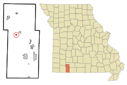
Location of McCord Bend, Missouri
|
|
| Country | United States |
| State | Missouri |
| County | Stone |
| Area | |
| • Total | 0.32 sq mi (0.84 km2) |
| • Land | 0.29 sq mi (0.76 km2) |
| • Water | 0.03 sq mi (0.08 km2) |
| Elevation | 997 ft (304 m) |
| Population
(2020)
|
|
| • Total | 212 |
| • Density | 723.55/sq mi (279.23/km2) |
| Time zone | UTC-6 (Central (CST)) |
| • Summer (DST) | UTC-5 (CDT) |
| ZIP code |
65656
|
| Area code(s) | 417 |
| FIPS code | 29-44829 |
| GNIS feature ID | 2399291 |
McCord Bend is a small village located in Stone County, Missouri, in the United States. In 2020, about 212 people lived there. It is part of the larger Branson, Missouri area, which is known for its entertainment and tourism.
Where is McCord Bend?
McCord Bend is located in a special spot right on a sharp bend of the James River. It is about 2.5 miles (4 kilometers) southwest of a town called Galena.
According to the United States Census Bureau, the village covers a total area of about 0.32 square miles (0.84 square kilometers). Most of this area, about 0.29 square miles (0.76 square kilometers), is land. A small part, about 0.03 square miles (0.08 square kilometers), is water.
How Many People Live Here?
| Historical population | |||
|---|---|---|---|
| Census | Pop. | %± | |
| 2000 | 292 | — | |
| 2010 | 297 | 1.7% | |
| 2020 | 212 | −28.6% | |
| U.S. Decennial Census | |||
Population in 2010
In 2010, the village of McCord Bend had 297 people living in 114 households. The average age of people in the village was about 41 years old.
- About 24% of the residents were under 18 years old.
- About 16% of the residents were 65 years or older.
Most of the people living in McCord Bend were White.
See also
 In Spanish: McCord Bend (Misuri) para niños
 | Bayard Rustin |
 | Jeannette Carter |
 | Jeremiah A. Brown |

