Galena, Missouri facts for kids
Quick facts for kids
Galena, Missouri
|
|
|---|---|

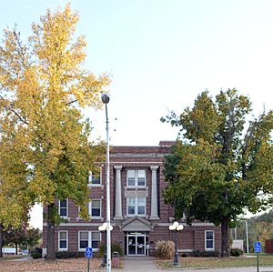
Stone County Courthouse
|
|

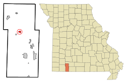
Location of Galena, Missouri
|
|
| Country | United States |
| State | Missouri |
| County | Stone |
| Area | |
| • Total | 0.76 sq mi (1.96 km2) |
| • Land | 0.75 sq mi (1.93 km2) |
| • Water | 0.01 sq mi (0.03 km2) |
| Elevation | 1,017 ft (310 m) |
| Population
(2020)
|
|
| • Total | 455 |
| • Density | 609.92/sq mi (235.53/km2) |
| Time zone | UTC-6 (Central (CST)) |
| • Summer (DST) | UTC-5 (CDT) |
| ZIP codes |
65624, 65656
|
| Area code(s) | 417 |
| FIPS code | 29-26254 |
Galena is a small city in Stone County, Missouri, United States. It is also the county seat, which means it's where the main government offices for the county are located. In 2020, about 455 people lived there. Galena is part of the larger Branson, Missouri area.
Contents
History of Galena
Galena was officially planned and laid out in 1852. It got its name from a type of ore called galena. This ore was found in the ground near where the town was first built. For a while, the town was also known as "Jamestown." A post office has been serving the community of Galena since 1853.
Exploring Galena's Geography
Galena covers a total area of about 0.76 square miles (1.96 square kilometers). Most of this area is land, with a small part being water. The James River flows along the east side of the town. This river eventually flows into the northern part of Table Rock Lake to the south.
The Historic Y-Bridge
Just east of Galena, you can find the historic Y-Bridge. This unique bridge crosses over the James River. It's called the Y-Bridge because of its shape, which looks like the letter "Y."
Galena's Climate and Weather
| Climate data for Galena, Missouri (1991–2020 normals, extremes 1963–present) | |||||||||||||
|---|---|---|---|---|---|---|---|---|---|---|---|---|---|
| Month | Jan | Feb | Mar | Apr | May | Jun | Jul | Aug | Sep | Oct | Nov | Dec | Year |
| Record high °F (°C) | 76 (24) |
83 (28) |
89 (32) |
96 (36) |
95 (35) |
105 (41) |
107 (42) |
110 (43) |
105 (41) |
92 (33) |
86 (30) |
78 (26) |
110 (43) |
| Mean maximum °F (°C) | 68.3 (20.2) |
73.1 (22.8) |
80.2 (26.8) |
85.1 (29.5) |
88.9 (31.6) |
93.5 (34.2) |
97.9 (36.6) |
98.7 (37.1) |
94.1 (34.5) |
86.1 (30.1) |
76.5 (24.7) |
69.6 (20.9) |
100.1 (37.8) |
| Mean daily maximum °F (°C) | 45.0 (7.2) |
49.7 (9.8) |
58.9 (14.9) |
68.5 (20.3) |
76.6 (24.8) |
85.1 (29.5) |
89.3 (31.8) |
89.2 (31.8) |
81.7 (27.6) |
70.4 (21.3) |
58.2 (14.6) |
47.3 (8.5) |
68.3 (20.2) |
| Daily mean °F (°C) | 33.4 (0.8) |
37.6 (3.1) |
46.4 (8.0) |
55.8 (13.2) |
64.9 (18.3) |
73.8 (23.2) |
77.7 (25.4) |
77.2 (25.1) |
68.8 (20.4) |
57.3 (14.1) |
45.6 (7.6) |
36.4 (2.4) |
56.2 (13.4) |
| Mean daily minimum °F (°C) | 21.9 (−5.6) |
25.5 (−3.6) |
33.9 (1.1) |
43.2 (6.2) |
53.2 (11.8) |
62.6 (17.0) |
66.1 (18.9) |
65.2 (18.4) |
55.9 (13.3) |
44.2 (6.8) |
33.0 (0.6) |
25.5 (−3.6) |
44.2 (6.8) |
| Mean minimum °F (°C) | 2.3 (−16.5) |
8.6 (−13.0) |
16.9 (−8.4) |
26.4 (−3.1) |
37.0 (2.8) |
49.8 (9.9) |
55.7 (13.2) |
53.3 (11.8) |
40.6 (4.8) |
27.7 (−2.4) |
17.0 (−8.3) |
10.0 (−12.2) |
−1.2 (−18.4) |
| Record low °F (°C) | −21 (−29) |
−16 (−27) |
2 (−17) |
16 (−9) |
28 (−2) |
36 (2) |
45 (7) |
40 (4) |
28 (−2) |
17 (−8) |
1 (−17) |
−18 (−28) |
−21 (−29) |
| Average precipitation inches (mm) | 2.48 (63) |
2.68 (68) |
4.39 (112) |
5.12 (130) |
5.46 (139) |
4.28 (109) |
4.14 (105) |
2.98 (76) |
4.28 (109) |
3.69 (94) |
4.32 (110) |
2.74 (70) |
46.56 (1,183) |
| Average snowfall inches (cm) | 3.6 (9.1) |
1.1 (2.8) |
1.4 (3.6) |
0.0 (0.0) |
0.0 (0.0) |
0.0 (0.0) |
0.0 (0.0) |
0.0 (0.0) |
0.0 (0.0) |
0.0 (0.0) |
0.0 (0.0) |
0.8 (2.0) |
6.9 (18) |
| Average precipitation days (≥ 0.01 in) | 6.6 | 5.7 | 8.7 | 9.2 | 10.6 | 9.3 | 8.1 | 6.7 | 7.6 | 7.9 | 7.4 | 6.0 | 93.8 |
| Average snowy days (≥ 0.1 in) | 1.1 | 0.9 | 0.4 | 0.0 | 0.0 | 0.0 | 0.0 | 0.0 | 0.0 | 0.0 | 0.0 | 0.5 | 2.9 |
| Source: NOAA | |||||||||||||
Galena's Population and People
| Historical population | |||
|---|---|---|---|
| Census | Pop. | %± | |
| 1860 | 55 | — | |
| 1870 | 27 | −50.9% | |
| 1880 | 85 | 214.8% | |
| 1910 | 353 | — | |
| 1920 | 390 | 10.5% | |
| 1930 | 508 | 30.3% | |
| 1940 | 507 | −0.2% | |
| 1950 | 439 | −13.4% | |
| 1960 | 389 | −11.4% | |
| 1970 | 391 | 0.5% | |
| 1980 | 423 | 8.2% | |
| 1990 | 401 | −5.2% | |
| 2000 | 451 | 12.5% | |
| 2010 | 440 | −2.4% | |
| 2020 | 455 | 3.4% | |
| U.S. Decennial Census | |||
Understanding the 2010 Census
In 2010, Galena had 440 people living in 179 households. About 116 of these were families. The city had a population density of about 587 people per square mile. Most of the people living in Galena were White (97.7%). A small percentage were Native American or from other backgrounds. About 3.6% of the population identified as Hispanic or Latino.
Many households (30.2%) had children under 18. About 45.8% of households were married couples. The average household had 2.46 people. The average age of residents in Galena was 41.5 years.
Notable People from Galena
Galena has been home to some interesting people:
- Pamela Pauly Chinnis: She was the first woman to become president of the House of Deputies.
- Dewey Jackson Short: He served as a U.S. Representative, which means he was a politician who represented the area in the United States government.
Getting Around: Transportation in Galena
Several state routes help people travel in and out of Galena:
- Missouri Route 176 (This road starts here)
- Missouri Route 248
- Missouri Route 265
- Missouri Route 413
Learning in Galena: Education
The Galena R-II School District runs the local schools. This includes one elementary school and Galena High School. Galena also has a public library, which is part of the Stone County Library system.
See also
 In Spanish: Galena (Misuri) para niños
 | Kyle Baker |
 | Joseph Yoakum |
 | Laura Wheeler Waring |
 | Henry Ossawa Tanner |

