McDonald County, Missouri facts for kids
Quick facts for kids
McDonald County
|
|
|---|---|

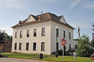
The Old McDonald County Courthouse in Pineville
|
|

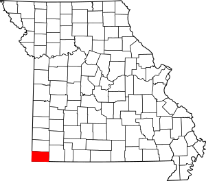
Location within the U.S. state of Missouri
|
|
 Missouri's location within the U.S. |
|
| Country | |
| State | |
| Founded | March 3, 1849 |
| Named for | Sergeant Alexander McDonald |
| Seat | Pineville |
| Largest city | Anderson |
| Area | |
| • Total | 540 sq mi (1,400 km2) |
| • Land | 539 sq mi (1,400 km2) |
| • Water | 0.2 sq mi (0.5 km2) 0.04% |
| Population
(2020)
|
|
| • Total | 23,303 |
| • Density | 43/sq mi (17/km2) |
| Time zone | UTC−6 (Central) |
| • Summer (DST) | UTC−5 (CDT) |
| Congressional district | 7th |
McDonald County is a county located in the southwestern part of Missouri, a state in the United States. In 2020, about 23,303 people lived here. The main town and county seat is Pineville.
The county was created in 1849. It was named after Sergeant Alexander McDonald. He was a soldier who fought in the American Revolutionary War. McDonald County has some important historical places. Two of these, the Old McDonald County Courthouse and the Powell Bridge, are listed on the National Register of Historic Places.
Contents
Geography of McDonald County
McDonald County covers a total area of about 540 square miles. Most of this area, about 539 square miles, is land. Only a tiny part, about 0.2 square miles, is water.
Neighboring Areas
McDonald County shares its borders with several other counties:
- Newton County (to the north)
- Barry County (to the east)
- Benton County, Arkansas (to the south)
- Delaware County, Oklahoma (to the west)
- Ottawa County, Oklahoma (to the northwest)
Main Roads
Several important highways run through McDonald County, connecting its communities and linking it to other areas:
 Interstate 49
 U.S. Route 71
 Route 43
 Route 59
 Route 76
 Route 90
Who Lives Here?
The number of people living in McDonald County has changed a lot over the years. In 1850, there were only 2,236 residents. By 1900, the population had grown to 13,574. In 2020, the county had 23,303 people.
A Look at the People (2000)
In 2000, there were 21,681 people living in McDonald County. These people lived in 8,113 households. About 5,865 of these were families. The average household had about 2.65 people. The average family had about 3.11 people.
Many households, about 35.7%, had children under 18 living with them. About 57.6% were married couples. The median age for people in the county was 34 years old. This means half the people were younger than 34, and half were older.
What the 2020 Census Shows
The 2020 census gives us a closer look at the people in McDonald County.
| Group | Number | Percentage |
|---|---|---|
| White (not Hispanic) | 16,667 | 71.5% |
| Black or African American (not Hispanic) | 421 | 1.8% |
| Native American (not Hispanic) | 493 | 2.12% |
| Asian (not Hispanic) | 376 | 1.61% |
| Pacific Islander (not Hispanic) | 868 | 3.72% |
| Other/Mixed (not Hispanic) | 1,660 | 7.12% |
| Hispanic or Latino | 2,818 | 12.1% |
Education
McDonald County has a strong focus on education. The main school system is the McDonald County R-I School District.
Public Schools
The McDonald County R-I School District serves students from pre-kindergarten through high school.
- McDonald County R-I School District - Anderson
- Noel Primary School (PK-02) - Noel
- Pineville Primary School (PK-02) - Pineville
- Anderson Elementary School (PK-05) - Anderson
- Noel Elementary School (03-08) - Noel
- Pineville Elementary School (03-08) - Pineville
- Rocky Comfort Elementary School (PK-08) - Rocky Comfort
- Southwest City Elementary School (PK-08) - Southwest City
- White Rock Elementary School (PK-08) - Jane
- Anderson Middle School (06-08) - Anderson
- McDonald County R-I High School (09-12) - Anderson
History of the School District
The McDonald County R-I School District was formed by combining several smaller school districts. This process was called consolidation. The first schools to join together were Pineville and Anderson. This was a big step to create a larger, stronger school system for the county.
The state offered money to help build a new high school if more districts joined. The goal was to bring most of the county's high schools into one system. The first combined class from Pineville and Anderson was the Class of 1966. This class chose the school mascot, the Mustang, and the school colors, red and black.
Later, the Noel School District also joined. There were discussions about where the new high school building should be. Eventually, a site near Anderson was chosen. Over time, other schools like Southwest City and Rocky Comfort also joined the McDonald County schools. This helped create the larger school district that exists today.
Public Libraries
- McDonald County Library
Communities
McDonald County is home to several cities, towns, and smaller communities.
Cities and Towns
- Anderson
- Ginger Blue
- Goodman
- Jane
- Lanagan
- Noel
- Pineville (county seat)
- Southwest City
Unincorporated Communities
These are smaller communities that are not officially organized as cities or towns.
Images for kids
See also
 In Spanish: Condado de McDonald para niños
 | Valerie Thomas |
 | Frederick McKinley Jones |
 | George Edward Alcorn Jr. |
 | Thomas Mensah |


