Pineville, Missouri facts for kids
Quick facts for kids
Pineville, Missouri
|
|
|---|---|

|
|
| Nickname(s):
The River City
|
|

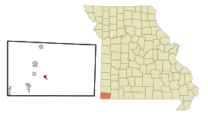
Location within McDonald County and the state of Missouri
|
|
| Country | United States |
| State | Missouri |
| County | McDonald |
| Area | |
| • Total | 3.29 sq mi (8.53 km2) |
| • Land | 3.29 sq mi (8.53 km2) |
| • Water | 0.00 sq mi (0.00 km2) |
| Elevation | 1,070 ft (330 m) |
| Population
(2020)
|
|
| • Total | 802 |
| • Density | 243.62/sq mi (94.06/km2) |
| Time zone | UTC-6 (Central (CST)) |
| • Summer (DST) | UTC-5 (CDT) |
| ZIP code |
64856
|
| Area code(s) | 417 |
| FIPS code | 29-57818 |
| GNIS feature ID | 2396212 |
Pineville is a small city in McDonald County, Missouri, United States. It is also the county seat, which means it's where the main government offices for McDonald County are located. In 2020, about 802 people lived there.
Contents
History of Pineville
Pineville was first planned in 1847 and was called "Maryville." However, there was already another town named Maryville, so the name was changed to "Pineville" in 1849. Some people say the town was named after a group of pine trees that grew where the town was first built. Others think the name came from a place called Pineville, Kentucky.
Pineville has a connection to movies! Two films, Jesse James (from 1939) and its follow-up Belle Starr (from 1941), were mostly filmed right here in Pineville.
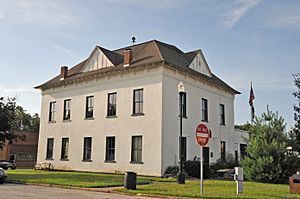
The historic Old McDonald County Courthouse is a special building in the county. It's now a museum run by the McDonald County Historical Society. This courthouse was added to the National Register of Historic Places on May 1, 2012. This list includes important places that are worth protecting because of their history.
Geography and Rivers
Pineville is located in the southern part of McDonald County. It sits just north of where two creeks, Big Sugar Creek and Little Sugar Creek, join together. When they meet, they form the Elk River.
The city of Noel is about 8 miles (13 km) southwest of Pineville, further down the Elk River. Anderson is about 6 miles (10 km) northwest, near U.S. Route 71. The major highway Interstate 49 runs west of Pineville, and you can get to it from exits 5 and 7. Interstate 49 goes north about 20 miles (32 km) to Neosho and south about 24 miles (39 km) to Bentonville, Arkansas.
Pineville covers a total area of about 3.29 square miles (8.53 km2), and all of it is land. Big Sugar Creek forms part of the city's eastern edge. The Elk River flows west through the city after Big and Little Sugar Creeks meet.
Population Changes
| Historical population | |||
|---|---|---|---|
| Census | Pop. | %± | |
| 1880 | 147 | — | |
| 1890 | 192 | 30.6% | |
| 1920 | 359 | — | |
| 1930 | 422 | 17.5% | |
| 1940 | 524 | 24.2% | |
| 1950 | 464 | −11.5% | |
| 1960 | 454 | −2.2% | |
| 1970 | 444 | −2.2% | |
| 1980 | 504 | 13.5% | |
| 1990 | 580 | 15.1% | |
| 2000 | 768 | 32.4% | |
| 2010 | 791 | 3.0% | |
| 2020 | 802 | 1.4% | |
| U.S. Decennial Census | |||
The population of Pineville has changed over many years. In 1880, only 147 people lived there. By 2020, the population had grown to 802 people.
2010 Census Information
In 2010, there were 791 people living in Pineville. The city had 287 households, and 185 of those were families. The average age of people in the city was about 33.8 years old. About 29.7% of the residents were under 18 years old.
Education
Public schools in Pineville are managed by the McDonald County R-1 School District.
Pineville also has a public library, which is called the McDonald County Library.
See also
 In Spanish: Pineville (Misuri) para niños
 | Calvin Brent |
 | Walter T. Bailey |
 | Martha Cassell Thompson |
 | Alberta Jeannette Cassell |

